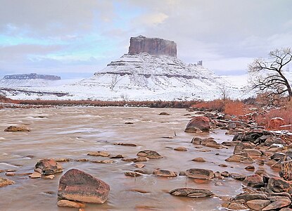
Castle Rock is a 400-foot (120 m) Wingate Sandstone tower standing on a 1,000 foot Moenkopi-Chinle cone above the northeastern border of Castle Valley, Utah. The tower is world-renowned as a subject for photography and for its classic rock climbing routes, the most famous of which is the Kor-Ingalls Route featured in Fifty Classic Climbs of North America. It can be accessed by a trail that begins south of the tower at a primitive camp ground.

Fisher Towers are a series of towers made of Cutler sandstone capped with Moenkopi sandstone and caked with a stucco of red mud located near Moab, Utah. The Towers are named for a miner who lived near them in the 1880s. The Towers are world-renowned as a subject for photography and for its classic rock climbing routes.

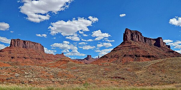
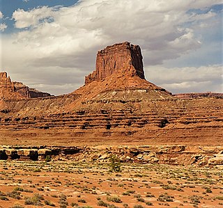
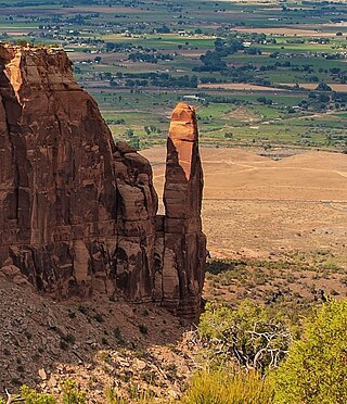
Parriott Mesa is a 6,155-foot-elevation sandstone summit in Grand County of Utah, United States. Parriott Mesa is located at Castle Valley, Utah, near the city of Moab. The name honors Dale M. Parriott (1885–1958), who was a Moab settler, and owned a ranch house in Castle Valley. Parriott Mesa is a thin 0.4 mile wide, and 1.5 mile long north-to-south mesa with 400 ft vertical Wingate Sandstone walls. Precipitation runoff from the mesa drains into the Colorado River which is about a mile away. The nearest higher peak is The Priest, 1.76 miles (2.83 km) to the east.

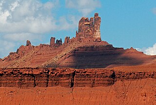
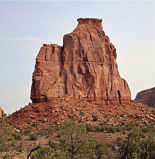
The Rectory is a 6,565-ft sandstone summit in Grand County of Utah, United States. The Rectory is located at Castle Valley, Utah, near the city of Moab. The Rectory is a thin 200 feet wide, and 1,000 feet long north-to-south butte with 200 ft vertical Wingate Sandstone walls tower standing on a 1,000 foot Moenkopi-Chinle base. Precipitation runoff from The Rectory drains into the nearby Colorado River. The nearest higher peak is Castleton Tower, 0.35 miles (0.56 km) to the south. Priest and Nuns are towers immediately north and part of The Rectory. Further northwest along the connecting ridge is The Convent, with a rock tower called Sister Superior between the two. The first ascent was made May 22, 1962, by Harvey Carter and Cleve McCarty via Empirical Route. Harvey Carter named this geological feature.
Merrimac Butte is a 5,627-foot (1,715-metre) sandstone summit located in Grand County, Utah, United States, about 12 miles northwest of the town of Moab. Merrimac Butte is a thin, 200–600-foot-wide and 1,600-foot-long east-to-west butte with 200-foot-tall vertical Entrada Sandstone walls overlaying a Carmel Formation base.
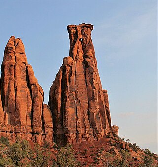
Sister Superior is a 6,037 ft elevation sandstone summit located southeast of The Convent in Grand County of Utah, United States. Sister Superior is located between Professor Valley and Castle Valley, near the city of Moab. It is situated east of Parriott Mesa and southwest of the Fisher Towers area. Remnants of an eroded butte, Sister Superior is a thin tower with 300+ ft vertical Wingate Sandstone walls standing on a 1,000 foot Moenkopi-Chinle base. The nearest higher peak is The Rectory (6,565 ft), 1.2 miles (1.9 km) to the south. Further south along the connecting ridge is Castleton Tower. Precipitation runoff from Sister Superior drains into the nearby Colorado River. The first ascent was made May 17, 1965, by Harvey Carter and David Bentley.

Monster Tower is a 600-foot (180-meter) tall sandstone tower located in the Island in the Sky District of Canyonlands National Park, in San Juan County, Utah, United States.

Washer Woman is a 500-foot (150-meter) tall sandstone arch and tower located in the Island in the Sky District of Canyonlands National Park, in San Juan County, Utah. It is situated 300 feet northwest of the slightly higher Monster Tower. Washer Woman is so named because the feature gives the appearance of a washerwoman bent over a washtub. This geographical feature's name was officially adopted in 1986 by the U.S. Board on Geographic Names after previously having similar names such as Washer-Woman Arch and The Washer Woman. Washer Woman and Monster Tower are an eroded fin composed of Wingate Sandstone, which is the remains of wind-borne sand dunes deposited approximately 200 million years ago in the Late Triassic. Airport Tower is set 1.6 mi (2.6 km) to the east, and Mesa Arch is situated 1.5 mi (2.4 km) to the west. A short hike to Mesa Arch provides the easiest view of Washer Woman. Access to this formation is via the four-wheel drive White Rim Road, which is the other option to see it. The top of this geological formation rises 1,300 feet above the road in approximately one mile. Precipitation runoff from Washer Woman drains southeast into the nearby Colorado River via Buck Canyon.

Owl Rock is a 6,547-foot elevation sandstone summit located south of Monument Valley, in northeast Arizona. It is situated 7 miles (11 km) north of Kayenta on Navajo Nation land, and can be seen from Highway 163 perched on the east edge of Tyende Mesa, where it towers 1,000 feet above the surrounding terrain. Its nearest higher neighbor is Agathla Peak, 1.4 miles (2.3 km) to the east-northeast, on the opposite side of this highway. Precipitation runoff from this feature drains into El Capitan Wash, which is part of the San Juan River drainage basin. The first ascent of Owl Rock was made in April 1966 by Fred Beckey and Harvey Carter by climbing cracks on the west face, and then bolting up a smooth south nose to the summit. They employed 20 pitons and 14 bolts on this route called Warpath. The descriptive name stems from its uncanny resemblance to an owl when viewed from the east. This feature is known as Bee 'Adizí in Navajo language meaning "spindle", and this sacred place is considered to be a spindle left behind by the Holy People. A newer name for it is Tsé Ts'óózí, meaning "Slim Rock".
Airport Tower is a 700-foot (210-meter) tall sandstone butte located in the Island in the Sky District of Canyonlands National Park, in San Juan County, Utah. It is situated 1.64 mile east of Washer Woman, which is a towering arch similar in height. Each are composed of Wingate Sandstone, which is the remains of wind-borne sand dunes deposited approximately 200 million years ago in the Late Triassic. The nearest higher neighbor is Monster Tower, 1.6 mi (2.6 km) to the west, Tiki Tower is one-half mile northwest, and Mesa Arch is situated 3.2 mi (5.1 km) to the west. A short hike to Mesa Arch provides the easiest view of Airport Tower. Access to this tower is via the four-wheel drive White Rim Road, which is another option to see Airport Tower. The top of this geological formation rises 1,400 feet above the road in less than one mile. Precipitation runoff from Airport Tower drains southeast into the nearby Colorado River via Buck and Lathrop Canyons. This geographical feature's name was officially adopted in 1986 by the U.S. Board on Geographic Names. It was so named because the rock formation resembles the appearance of an airport control tower.

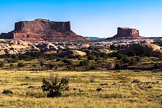
Buttes of the Cross is two sandstone summits located in the northern reach of Glen Canyon National Recreation Area, in Wayne County of Utah, United States. The larger and higher south butte reaches an elevation of 5,642 feet, whereas the north butte rises to 5,569 feet, with approximately 0.6 miles (0.97 km) separation between them. When viewed from the north-northeast near Labyrinth Canyon, they align to form the shape of a cross, creating the appearance of a single butte. The name "Butte of the Cross" was first applied by John Wesley Powell during the Powell Geographic Expedition of 1869. A few miles further down the Green River, Powell finds that this geographical feature is two buttes when viewed from the east, so it was renamed Buttes of the Cross. Buttes of the Cross towers over 1,400 feet above its surrounding terrain. It is situated 6.8 miles west of Candlestick Tower, and one-half mile outside the boundary of Canyonlands National Park.

Chip and Dale Towers are two 300-foot (91-meter) tall sandstone towers located in the Island in the Sky District of Canyonlands National Park, in San Juan County, Utah. Dale Tower rises to an elevation of 5,620 feet, whereas the lower Chip Tower is 5,420-feet. Airport Tower is set 2.5 mi (4.0 km) to the southwest, and Dead Horse Point State Park overlook is situated 4.5 mi (7.2 km) to the north-northeast. Chip and Dale Towers are an eroded fin composed of hard, fine-grained Wingate Sandstone, which is the remains of wind-borne sand dunes deposited approximately 200 million years ago in the Late Triassic. This Wingate Sandstone overlays a softer layer of the Chinle Formation. Access to the towers is via the four-wheel drive White Rim Road, and a scramble to reach the base. The top of the towers rise over 1,000 feet above the road in approximately one-half mile. Precipitation runoff from Chip and Dale Towers drains east to the nearby Colorado River.

The Sixshooter Peaks are two iconic sandstone summits located in Bears Ears National Monument in San Juan County, Utah, United States. The larger and higher North Sixshooter Peak rises to an elevation of 6,379 feet, whereas South Sixshooter Peak rises to 6,154 feet, with approximately 1.5 miles (2.4 km) separation between the two. These buttes tower nearly 1,400 feet above the surrounding terrain, and are historic landmarks visible from State Route 211 between Newspaper Rock and the Needles District of Canyonlands National Park. They are situated 1.5 mile outside the boundary of the park, and four miles northwest of Bridger Jack Butte. Variant names for the peaks include "North Six-Shooter Peak", "South Six-shooter Peak", "Six Shooter Peaks", and "Six-shooter Peak". They are so named because of their resemblance to a pair of revolvers pointing skyward.

Bridger Jack Butte is a sandstone butte located in Bears Ears National Monument, in San Juan County, Utah, United States. Set at the northern tip of Bridger Jack Mesa and above the confluence of Indian and Lavender Creeks, the summit rises to an elevation of 5,890 feet, and towers over 700 feet above the surrounding terrain and floor of Lavender Canyon to its west. This landmark is situated four miles southeast of the Sixshooter Peaks, and is visible from State Route 211 between Newspaper Rock and the Needles District of Canyonlands National Park. "Bridger Jack" was a Paiute medicine man.
Independence Monument is a 5,739-foot-elevation sandstone pillar located in Colorado National Monument, in Mesa County of western Colorado, United States. This iconic 450-foot-high landmark is situated one mile southeast of the monument's visitor center, and 9 miles (14 km) west of the community of Grand Junction, where it towers above the floor of Monument Canyon and Wedding Canyon. It is a popular climbing destination, and can be seen from Rim Rock Drive.
Kissing Couple is a 5,815-foot-elevation (1,772-meter) sandstone pillar located in Colorado National Monument, in Mesa County of western Colorado, United States. This iconic 400-foot-high tower is situated on the west side of Monument Canyon, 1.5 mile southeast of the monument's visitor center, and 9 miles (14 km) west of the community of Grand Junction. It is also a half-mile south-southeast of another popular climbing destination, Independence Monument, and both can be seen from viewpoints along Rim Rock Drive. It is so named because it resembles an embracing couple. This geographical feature's name was officially adopted in 1982 by the United States Board on Geographic Names. Older USGS maps have the feature's name misplaced by about one-half mile to the southeast. The first ascent of the summit was made May 4, 1960, by Layton Kor, Harvey Carter, and John Auld via the five pitch, class 5.11a route named Long Dong Wall. The first free ascent was made in 1977 by Andy Petefish, Tom Stubbs, and Jim Pearson. Some climbers alternatively refer to Kissing Couple as "Bell Tower."

Pipe Organ is a 5,731-foot-elevation (1,747-meter) sandstone pillar located in Colorado National Monument, in Mesa County of western Colorado, United States. This 400+ foot tower is situated in Wedding Canyon, less than one-half mile east of the monument's visitor center, and 9 miles (14 km) west of the community of Grand Junction. It is also immediately northwest of another popular climbing destination, Independence Monument, and both can be seen from viewpoints along Rim Rock Drive. The first ascent of the summit was made January 31, 1961, by John Auld, Gary Ziegler, Jim Dyson, and John Kuglin. Pipe Organ has a subsidiary summit unofficially named Organ Pipe Spire on the east aspect, which the National Park Service refers to as Praying Hands. This 325-foot-high subsidiary peak was originally named Squall Spire in 1976 by Harvey T. Carter of the first ascent party.
Sentinel Spire is a 5,500-foot-elevation (1,700-meter) sandstone pillar located in Colorado National Monument, in Mesa County of western Colorado, United States. This 200-foot freestanding tower is situated in Wedding Canyon, one-half mile east of the monument's visitor center, and 9 miles (14 km) west of the community of Grand Junction. It is also immediately south of Window Rock, and north of another climbing destination, Pipe Organ, both of which can be seen from viewpoints along Rim Rock Drive. The first ascent of the summit was made May 3, 1960, by Layton Kor, Harvey Carter, and John Auld via the class 5.10 route, Fast Draw. This was the day before the climbers also made the first ascent of nearby Kissing Couple. The first solo ascent was made by Ron Olevsky in March 1976, and the first free ascent was made by Andy Petefish and John Christenson in 1978. Some climbers refer to Sentinel Spire as Watusi Spear.

Grand View Spire is a 5,821-foot-elevation (1,774-meter) sandstone pillar located in Colorado National Monument, in Mesa County of western Colorado, United States. This 400-foot tower is situated on the west side of Monument Canyon, one mile southeast of the monument's visitor center, and 9 miles (14 km) west of the community of Grand Junction. It is also 0.32 mile immediately south of Independence Monument, and 0.27 mile northwest of another climbing destination, Kissing Couple. Its unofficial name relates to its position at the tip of Grand View Overlook, one of several scenic viewpoints along Rim Rock Drive.

Terra Tower is a 5,790-foot-elevation (1,760-meter) sandstone pillar located in Colorado National Monument, in Mesa County of western Colorado, United States. This 350-foot-high tower is situated on the Redlands escarpment, approximately seven miles west of the community of Grand Junction. Topographic relief is significant as it rises 1,000 feet above the Tiara Rado Golf Course in approximately one-half mile. The first ascent of the summit was made in 1979 by Harvey Carter and Tom Merrill via the class 5.11 route, Way Bazaar.