Stephanie "Steph" Davis is an American rock climber, BASE jumper, and wingsuit flyer. She is one of the world's leading climbers, having completed some of the hardest routes in the world. She has free soloed up to 5.11a (6b+), and was the first woman to summit all the peaks of the Fitzroy Range in Patagonia, the second woman to free climb El Capitan in a day, the first woman to free climb the Salathė Wall on El Capitan, the first woman to free solo The Diamond on Longs Peak in Colorado, and the first woman to summit Torre Egger. Davis was married to fellow climbers and BASE jumpers Dean Potter and Mario Richard, and currently to sky-diving instructor, flyer, and jumper Ian Mitchard. Davis is also a blogger who writes about her interests in climbing, BASE jumping, yoga, and veganism.

Fisher Towers are a series of towers made of Cutler sandstone capped with Moenkopi sandstone and caked with a stucco of red mud located near Moab, Utah. The Towers are named for a miner who lived near them in the 1880s. The Towers are world-renowned as a subject for photography and for its classic rock climbing routes.

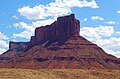
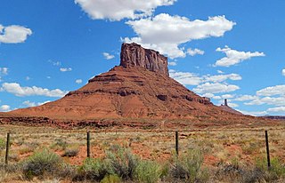
The Titan is a 6,112-foot-elevation (1,863-meter) pillar in Grand County, Utah, United States.

The Rectory is a 6,565-ft sandstone summit in Grand County of Utah, United States. The Rectory is located at Castle Valley, Utah, near the city of Moab. The Rectory is a thin 200 feet wide, and 1,000 feet long north-to-south butte with 200 ft vertical Wingate Sandstone walls tower standing on a 1,000 foot Moenkopi-Chinle base. Precipitation runoff from The Rectory drains into the nearby Colorado River. The nearest higher peak is Castleton Tower, 0.35 miles (0.56 km) to the south. Priest and Nuns are towers immediately north and part of The Rectory. Further northwest along the connecting ridge is The Convent, with a rock tower called Sister Superior between the two. The first ascent was made May 22, 1962, by Harvey Carter and Cleve McCarty via Empirical Route. Harvey Carter named this geological feature.
Convent Mesa, or The Convent, or simply Convent, are alternative names for a 5,955-foot elevation sandstone summit in Grand County of Utah, United States. The Convent is located in Professor Valley, near the city of Moab. It is situated northeast of Parriott Mesa and southwest of the Fisher Towers area. The Convent is a 1,000 feet wide, and 3,000 feet long northwest-to-southeast trending butte with 400-ft vertical Wingate Sandstone walls. The nearest higher peak is Sister Superior (6,037 ft), 0.91 miles (1.46 km) to the southeast. Further southeast along the connecting ridge are The Rectory and Castleton Tower. Precipitation runoff from The Convent drains into the nearby Colorado River. The first ascent of Convent was made in November 1965 by Harvey Carter and Steve Miller via the Salvation Chimney climbing route.
Merrimac Butte is a 5,627-foot (1,715-metre) sandstone summit located in Grand County, Utah, United States, about 12 miles northwest of the town of Moab. Merrimac Butte is a thin, 200–600-foot-wide and 1,600-foot-long east-to-west butte with 200-foot-tall vertical Entrada Sandstone walls overlaying a Carmel Formation base.
Sister Superior is a 6,037 ft elevation sandstone summit located southeast of The Convent in Grand County of Utah, United States. Sister Superior is located between Professor Valley and Castle Valley, near the city of Moab. It is situated east of Parriott Mesa and southwest of the Fisher Towers area. Remnants of an eroded butte, Sister Superior is a thin tower with 300+ ft vertical Wingate Sandstone walls standing on a 1,000 foot Moenkopi-Chinle base. The nearest higher peak is The Rectory (6,565 ft), 1.2 miles (1.9 km) to the south. Further south along the connecting ridge is Castleton Tower. Precipitation runoff from Sister Superior drains into the nearby Colorado River. The first ascent was made May 17, 1965, by Harvey Carter and David Bentley.

Bridger Jack Butte is a sandstone butte located in Bears Ears National Monument, in San Juan County, Utah, United States. Set at the northern tip of Bridger Jack Mesa and above the confluence of Indian and Lavender Creeks, the summit rises to an elevation of 5,890 feet, and towers over 700 feet above the surrounding terrain and floor of Lavender Canyon to its west. This landmark is situated four miles southeast of the Sixshooter Peaks, and is visible from State Route 211 between Newspaper Rock and the Needles District of Canyonlands National Park. "Bridger Jack" was a Paiute medicine man.
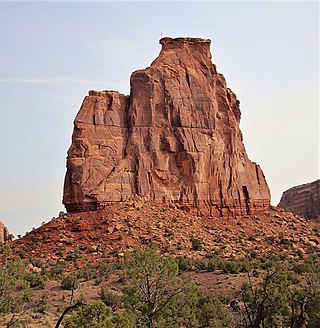
Independence Monument is a 5,739-foot-elevation sandstone pillar located in Colorado National Monument, in Mesa County of western Colorado, United States. This iconic 450-foot-high landmark is situated one mile southeast of the monument's visitor center, and 9 miles (14 km) west of the community of Grand Junction, where it towers above the floor of Monument Canyon and Wedding Canyon. It is a popular climbing destination, and can be seen from Rim Rock Drive.
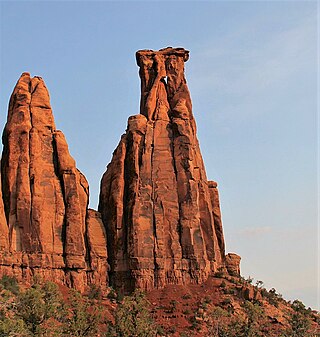
Kissing Couple is a 5,815-foot-elevation (1,772-meter) sandstone pillar located in Colorado National Monument, in Mesa County of western Colorado, United States. This iconic 400-foot-high tower is situated on the west side of Monument Canyon, 1.5 mile southeast of the monument's visitor center, and nine miles (14 km) west of the community of Grand Junction. It is also a half-mile south-southeast of another popular climbing destination, Independence Monument, and both can be seen from viewpoints along Rim Rock Drive. It is so named because it resembles an embracing couple. This geographical feature's name was officially adopted in 1982 by the United States Board on Geographic Names. Older USGS maps have the feature's name misplaced by about one-half mile to the southeast. The first ascent of the summit was made May 4, 1960, by Layton Kor, Harvey Carter, and John Auld via the five pitch, class 5.11a route named Long Dong Wall. The first free ascent was made in 1977 by Andy Petefish, Tom Stubbs, and Jim Pearson. Some climbers alternatively refer to Kissing Couple as "Bell Tower."
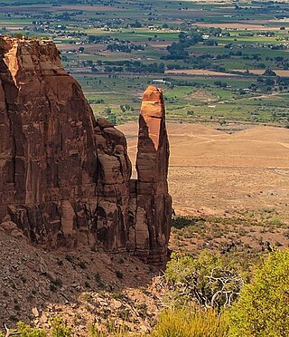
Sentinel Spire is a 5,500-foot-elevation (1,676-meter) sandstone pillar located in Colorado National Monument, in Mesa County of western Colorado, United States. This 200-foot freestanding tower is situated in Wedding Canyon, one-half mile east of the monument's visitor center, and 9 miles (14 km) west of the community of Grand Junction. It is also immediately south of Window Rock, and north of another climbing destination, Pipe Organ, both of which can be seen from viewpoints along Rim Rock Drive. The first ascent of the summit was made May 3, 1960, by Layton Kor, Harvey Carter, and John Auld via the class 5.10 route, Fast Draw. This was the day before the climbers also made the first ascent of nearby Kissing Couple. The first solo ascent was made by Ron Olevsky in March 1976, and the first free ascent was made by Andy Petefish and John Christenson in 1978. Some climbers refer to Sentinel Spire as Watusi Spear.

Grand View Spire is a 5,821-foot-elevation (1,774-meter) sandstone pillar located in Colorado National Monument, in Mesa County of western Colorado, United States. This 400-foot tower is situated on the west side of Monument Canyon, one mile southeast of the monument's visitor center, and 9 miles (14 km) west of the community of Grand Junction. It is also 0.32 mile immediately south of Independence Monument, and 0.27 mile northwest of another climbing destination, Kissing Couple. Its unofficial name relates to its position at the tip of Grand View Overlook, one of several scenic viewpoints along Rim Rock Drive.

De Gaulle and His Troops is a 5,540-foot-elevation (1,689-meter) summit in San Juan County, Utah, United States.

Adobe Mesa is a 7,475-foot-elevation (2,278-meter) summit in Grand County, Utah, United States.

Kingfisher Tower is a 6,794-foot-elevation (2,071-meter) pillar in Grand County, Utah, United States.
Three Penguins is a 4,488-foot-elevation (1,368-meter) summit in Grand County, Utah, United States.

Cottontail Tower is a 5,980-foot-elevation (1,823-meter) pillar in Grand County, Utah, United States.

Ancient Art is a 5,420-foot-elevation (1,652-meter) pillar in Grand County, Utah, United States.

Echo Tower is a 5,784-foot-elevation (1,763-meter) pillar in Grand County, Utah, United States.

The Oracle is a 6,060-foot-elevation (1,847-meter) pillar in Grand County, Utah, United States.