Coraki, New South Wales

Last updated

Coraki
New South Wales
Coraki Hotel.jpg
The Coraki Hotel on Richmond Terrace, Coraki's main street
Australia New South Wales location map blank.svg
Red pog.svg
Coraki
Coordinates 28°59′0″S153°18′0″E / 28.98333°S 153.30000°E / -28.98333; 153.30000
Population1,155 (2021 census) [1]
Established1849
Postcode(s) 2471
LGA(s) Richmond Valley Council
State electorate(s) Clarence
Federal division(s) Page

Coraki is a small town that sits on the confluence of the Richmond and Wilsons Rivers in northern New South Wales, Australia in Richmond Valley Shire. At the 2021 census, Coraki had a population of 1,277 people. [1]

Contents

History

The name Coraki is derived from the Bundjalung word gurigay, meaning the meeting of the waters, [2] and the Bundjalung people are the traditional owners of the area. [3]

The village was founded by William Yabsley in 1849 when Lismore was only a small cattle station and Casino had only one store and a hotel. Yabsley and his family obtained the lease to Brook Station and established the first permanent settlement. He built his shipyard just above The Junction, as it was first called. Many ships and river boats were launched there and Yabsley opened a store for provisions for the cedar cutters who came to the district. Transport at the time was almost entirely by water and Coraki was the busiest port on the Richmond River.

Description

Coraki is positioned centrally to the hub of the Summerland Way Casino (30 km (19 mi) west), the regional city of Lismore (25 km (16 mi) north) and the popular tourist beachside location of Evans Head (25 km (16 mi) east). At the western boundary of Coraki township lies Box Ridge, an Aboriginal community.

Like many other towns in the area, it is a hub for the local agricultural industries such as cattle, sugar cane and tea tree oil.

Coraki is a small village with many community facilities: Coraki Fire Station, Coraki Public School, St Joseph's Primary School, St Joseph's Church, Coraki Uniting Church, Coraki Anglican Church, Coraki Community Hall, the Rural Transaction Centre, Mid-Richmond Museum, Coraki Library, post office, Mid-Richmond Retirement Village, cemetery, hockey fields, tennis courts, skate park, boat ramp, and the Memorial Park with barbecue, playground and picnic facilities aligning the "healing stones" riverside path. There is a number of local businesses, including the historic Coraki Hotel on Richmond Terrace.

Events

Coraki is the home of the annual Coraki Art Prize (formerly the Coraki Tea Tree Art Prize) and an art competition and exhibition open to all artists and including painting, drawing, photography, sculpture and printmaking, held late October.

In 2010, the first Dylanfest celebrated the music, art and poetry of Bob Dylan in October at the Coraki Hotel.

Annually in November, the Tweed Water Skiing Club converges on the Richmond River to contest the "Coraki Assault" race.

Population

Historical population
YearPop.±%
1976912    
1981895−1.9%
19861,047+17.0%
19911,103+5.3%
19961,223+10.9%
20011,155−5.6%
20061,180+2.2%
20111,215+3.0%
20161,094−10.0%
20211,155+5.6%
Source: Australian Bureau of Statistics data. [4] [5]

According to the 2021 Census of Population, there were 1,155 people in Coraki, with the following demographic features: [1]

Native title

In late April 2021, the Federal Court of Australia convened at Evans Head, where a native title determination was made over 7.2 square kilometres (2.8 sq mi) of land, consisting of 52 separate areas of land. Included in the land is a bora ring of great cultural significance to the Bundjalung people, near Coraki. [3]

Related Research Articles

<span class="mw-page-title-main">Grafton, New South Wales</span> City in New South Wales, Australia

Grafton is a city in the Northern Rivers region of the Australian state of New South Wales. It is located on the Clarence River, on a floodplain, approximately 608 kilometres (378 mi) by road north-northeast of the state capital Sydney.

<span class="mw-page-title-main">Lismore, New South Wales</span> City in New South Wales, Australia

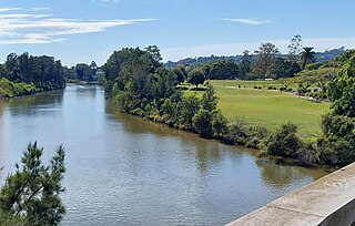
Lismore is a city located in the Northern Rivers region of New South Wales, Australia and the main population centre in the City of Lismore local government area, it is also a regional centre in the Northern Rivers region of the state. Lismore is 734 km (456 mi) north of Sydney and 200 km (120 mi) south of Brisbane. It is situated on a low floodplain on the banks of the Wilsons River near the latter's junction with Leycester Creek, both tributaries of the Richmond River which enters the Pacific Ocean at Ballina, 30 km (19 mi) to the east.
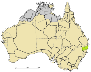
<span class="mw-page-title-main">Warren, New South Wales</span> Town in New South Wales, Australia

Warren is a town in the Orana Region of New South Wales, Australia. It is located off the Mitchell Highway, 120 kilometres north west of Dubbo, and is the seat of the Warren Shire local government area. At the 2016 census, Warren had a population of 1,530. Warren is included in the Central West Slopes and Plains division of the Bureau of Meteorology forecasts.

<span class="mw-page-title-main">Northern Rivers</span> Region in New South Wales, Australia

Northern Rivers is the most north-easterly region of the Australian state of New South Wales, located between 590 and 820 kilometres north of the state capital, Sydney, and encompasses the catchments and fertile valleys of the Clarence, Richmond, and Tweed rivers. It extends from Tweed Heads in the north to the southern extent of the Clarence river catchment which lies between Grafton and Coffs Harbour, and includes the main towns of Tweed Heads, Byron Bay, Ballina, Kyogle, Lismore, Casino and Grafton. At its most northern point, the region is 102 kilometres (63 mi) south-southeast of the Queensland capital, Brisbane.

<span class="mw-page-title-main">Ballina, New South Wales</span> Town in New South Wales, Australia

Ballina is a town in the Northern Rivers region of New South Wales, Australia, and the seat of the Ballina Shire local government area. It lies 740 km (460 mi) north of Sydney and 185 km (115 mi) south of Brisbane. Ballina's urban population at the end of 2021 was 46,190. The town lies on the Richmond River and serves as a gateway to Byron Bay.

<span class="mw-page-title-main">Nimbin, New South Wales</span> Town in Australia

Nimbin is a town in the Northern Rivers area of the Australian state of New South Wales, approximately 30 km (19 mi) north of Lismore, 33 km (21 mi) northeast of Kyogle, and 70 km (43 mi) west of Byron Bay.

<span class="mw-page-title-main">Kyogle</span> Town in New South Wales, Australia

Kyogle is a town in the Northern Rivers region of northern New South Wales, Australia. It falls within the local government area of Kyogle Council. At the 2016 census, Kyogle had a population of 2,751 people. Kyogle is known as a "gateway" to many national parks including Border Ranges National Park and Toonumbar National Park.

<span class="mw-page-title-main">Casino, New South Wales</span> Town in New South Wales, Australia

Casino is a town in the Northern Rivers area of New South Wales, Australia, with a population of 9,968 people at the 2021 census. It lies on the banks of the Richmond River and is situated at the junction of the Bruxner Highway and the Summerland Way.

<span class="mw-page-title-main">Mullumbimby</span> Town in New South Wales, Australia

Mullumbimby is an Australian town in the Byron Shire in the Northern Rivers region of New South Wales. It promotes itself as "The Biggest Little Town in Australia". The town lies at the foot of Mount Chincogan in the Brunswick Valley about 9 kilometres by road from the coast. At the 2021 census, Mullumbimby and the surrounding area had a population of 3,589 people. It was first inhabited by Indigenous Australian peoples.

<span class="mw-page-title-main">Richmond River</span> River in New South Wales, Australia

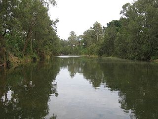
The Richmond River is a river situated in the Northern Rivers region of New South Wales, Australia.

<span class="mw-page-title-main">Richmond Valley Council</span> Local government area in New South Wales, Australia

Richmond Valley Council (RVC) is a local government area on the Northern Rivers region of north-eastern New South Wales, Australia. RVC services an area of 3,051 square kilometres (1,178 sq mi) and draws its name from the Richmond River, which flows through most of the council area. The area under management is located adjacent to the Bruxner Highway, Pacific Highway, and the North Coast railway line.

<span class="mw-page-title-main">Evans Head, New South Wales</span> Seaside village in New South Wales, Australia

Evans Head is a town in Richmond Valley Council of the Northern Rivers region of New South Wales, Australia. At the 2016 census, Evans Head had a population of 2,843 people. It is 726 kilometres north of Sydney, and 11 kilometres east off the Pacific Highway from Woodburn.

<span class="mw-page-title-main">Woodburn, New South Wales</span> Town in New South Wales, Australia

Woodburn is a small highway town on the banks of the Richmond River in New South Wales, Australia. Until the town was bypassed in September 2020, the busy Pacific Highway passed through the centre of town. Woodburn is 712 km north of the state capital, Sydney, and 34 km south of the regional city of Lismore.

<span class="mw-page-title-main">Yugambeh–Bundjalung languages</span> Language branch spoken in Australia

Yugambeh–Bundjalung, also known as Bandjalangic, is a branch of the Pama–Nyungan language family, that is spoken in north-eastern New South Wales and South-East Queensland.

<span class="mw-page-title-main">Tabulam</span> Town in New South Wales, Australia

Tabulam is a rural village in the far north-east of New South Wales, Australia, 800 kilometres from the state capital, Sydney. Tabulam is located on the Bruxner Highway between Tenterfield and Casino and on the Clarence River. According to the 2016 census, there were 470 people living in Tabulam. The main village is administered by Kyogle Council, while the section of Tabulam west of the Clarence River is part of Tenterfield Shire.

<i>Koori Mail</i> Australian newspaper written and owned by Indigenous Australians

The Koori Mail is an Australian newspaper written and owned by Indigenous Australians since 1991. It is published fortnightly in printed form and electronic copies are available. Owned by five community-based Aboriginal organisations based in Lismore, in northern New South Wales, its profits are spent on community projects and needs. "Koori" is a demonym for the Aboriginal peoples of parts of New South Wales and Victoria.

<span class="mw-page-title-main">Bundjalung people</span> Aboriginal Australian people of New South

The Bundjalung people, also spelled Bunjalung, Badjalang and Bandjalang, are Aboriginal Australians who are the original custodians of a region from around Grafton in northern coastal New South Wales to Beaudesert in south-east Queensland. The region is located approximately 550 kilometres (340 mi) northeast of Sydney and 100 kilometres (62 mi) south of Brisbane that now includes the Bundjalung National Park.

<span class="mw-page-title-main">Wilsons River (New South Wales)</span> River in New South Wales, Australia

Wilsons River, a perennial river and part of the Richmond River catchment, is situated in the Northern Rivers district of New South Wales, Australia.

Rappville is a small village in northern New South Wales, Australia. At the 2016 census, Rappville recorded a population of 169 people.

The Arakwal are an Aboriginal Australian people of the state of New South Wales.

References

  1. 1 2 3 Australian Bureau of Statistics (28 June 2022). "Coraki (State Suburb)". 2021 Census QuickStats. Retrieved 23 January 2024. OOjs UI icon edit-ltr-progressive.svg CC-BY icon.svg Material was copied from this source, which is available under a Creative Commons Attribution 4.0 International License Archived 16 October 2017 at the Wayback Machine .
  2. Sharpe, Margaret. "Bundjalung". Macquarie Aboriginal Words. Sydney: Macquarie Library. p. 21.
  3. 1 2 Ross, Hannah (30 April 2021). "NSW Bandjalang people victorious after 25-year native title fight". ABC News (Australian Broadcasting Corporation). Retrieved 7 May 2021.
  4. "Statistics by Catalogue Number". Australian Bureau of Statistics. Retrieved 23 January 2024.
  5. "Search Census data". Australian Bureau of Statistics. Retrieved 23 January 2024.