County of Cardwell, Queensland

Last updated

Cardwell
Queensland
Cardwell-county-queensland.png
Location within Queensland
Lands administrative divisions around Cardwell:
Hodgkinson Nares Coral Sea
Lynd Cardwell Coral Sea
Gunnawarra Wairuna Wilkie Gray
Map all coordinates using: OpenStreetMap  
Download coordinates as: KML  ·  GPX

The County of Cardwell is a county (a cadastral division) in Far North Queensland, Queensland, Australia, between Cairns and Townsville. It was named and bounded by the Governor in Council on 7 March 1901 under the Land Act 1897. [1] [2] Its name likely honours Edward Cardwell, who was Secretary of State for the Colonies in 1864–1866 and later served as a reformist Secretary of State for War.

Contents

Parishes

Cardwell is divided into parishes, as listed below:

ParishLGACoordinatesTowns
Alcock Cassowary Coast 17°48′S145°45′E / 17.800°S 145.750°E / -17.800; 145.750 (Alcock Parish)
Armstrong Tablelands 18°05′S145°23′E / 18.083°S 145.383°E / -18.083; 145.383 (Armstrong Parish)
Ashton Hinchinbrook 18°37′S145°50′E / 18.617°S 145.833°E / -18.617; 145.833 (Ashton Parish)
BanktonCassowary Coast 18°01′S145°38′E / 18.017°S 145.633°E / -18.017; 145.633 (Bankton Parish)
BerwickHinchinbrook 18°46′S146°02′E / 18.767°S 146.033°E / -18.767; 146.033 (Berwick Parish)
BlencoeTablelands 18°07′S145°35′E / 18.117°S 145.583°E / -18.117; 145.583 (Blencoe Parish) Kirrama
CoolgarraTablelands 17°35′S145°10′E / 17.583°S 145.167°E / -17.583; 145.167 (Coolgarra Parish)
CordeliaHinchinbrook 18°38′S146°15′E / 18.633°S 146.250°E / -18.633; 146.250 (Cordelia Parish) Ingham, Halifax, Lucinda
DunkalliCassowary Coast 17°59′S146°10′E / 17.983°S 146.167°E / -17.983; 146.167 (Dunkalli Parish) Dunk Island
EllerbeckCassowary Coast 18°19′S146°03′E / 18.317°S 146.050°E / -18.317; 146.050 (Ellerbeck Parish) Cardwell
GarrawaltHinchinbrook 18°28′S145°50′E / 18.467°S 145.833°E / -18.467; 145.833 (Garrawalt Parish) Abergowrie
GlenboraCassowary Coast 18°16′S145°54′E / 18.267°S 145.900°E / -18.267; 145.900 (Glenbora Parish)
GoshenTablelands 18°11′S145°24′E / 18.183°S 145.400°E / -18.183; 145.400 (Goshen Parish)
HecateCassowary Coast 18°13′S146°12′E / 18.217°S 146.200°E / -18.217; 146.200 (Hecate Parish)
HerbertonTablelands 17°26′S145°25′E / 17.433°S 145.417°E / -17.433; 145.417 (Herberton Parish) Herberton
IsmailiaTablelands 17°48′S145°30′E / 17.800°S 145.500°E / -17.800; 145.500 (Ismailia Parish)
KirramaCassowary Coast 18°10′S145°43′E / 18.167°S 145.717°E / -18.167; 145.717 (Kirrama Parish)
LannercostHinchinbrook 18°36′S145°59′E / 18.600°S 145.983°E / -18.600; 145.983 (Lannercost Parish) Long Pocket
LeachHinchinbrook 18°27′S146°00′E / 18.450°S 146.000°E / -18.450; 146.000 (Leach Parish)
LeefeCassowary Coast 18°21′S145°55′E / 18.350°S 145.917°E / -18.350; 145.917 (Leefe Parish)
MarathonHinchinbrook 18°34′S146°10′E / 18.567°S 146.167°E / -18.567; 146.167 (Marathon Parish) Macknade
MeungaCassowary Coast 18°09′S145°54′E / 18.150°S 145.900°E / -18.150; 145.900 (Meunga Parish) Kennedy
MillstreamTablelands 17°43′S145°20′E / 17.717°S 145.333°E / -17.717; 145.333 (Millstream Parish)
MorecambeTablelands 17°50′S145°05′E / 17.833°S 145.083°E / -17.833; 145.083 (Morecambe Parish)
MullaburraTablelands 17°42′S145°07′E / 17.700°S 145.117°E / -17.700; 145.117 (Mullaburra Parish) Mount Garnet
NiagaraTablelands 18°19′S145°45′E / 18.317°S 145.750°E / -18.317; 145.750 (Niagara Parish)
OngeraTablelands 17°43′S145°37′E / 17.717°S 145.617°E / -17.717; 145.617 (Ongera Parish)
PalmHinchinbrook 18°42′S146°33′E / 18.700°S 146.550°E / -18.700; 146.550 (Palm Parish) Palm Island
PittCassowary Coast 18°26′S146°09′E / 18.433°S 146.150°E / -18.433; 146.150 (Pitt Parish)
RamlehTablelands 17°53′S145°38′E / 17.883°S 145.633°E / -17.883; 145.633 (Ramleh Parish)
RavenshoeTablelands 17°38′S145°30′E / 17.633°S 145.500°E / -17.633; 145.500 (Ravenshoe Parish) Ravenshoe, Tumoulin
RockinghamCassowary Coast 17°56′S145°57′E / 17.933°S 145.950°E / -17.933; 145.950 (Rockingham Parish) Tully
Silver ValleyCharters Towers 17°28′S145°17′E / 17.467°S 145.283°E / -17.467; 145.283 (Silver Valley Parish)
StoneHinchinbrook 18°48′S145°53′E / 18.800°S 145.883°E / -18.800; 145.883 (Stone Parish) Upper Stone
StralochCassowary Coast 18°25′S146°18′E / 18.417°S 146.300°E / -18.417; 146.300 (Straloch Parish)
TimsahTablelands 17°57′S145°30′E / 17.950°S 145.500°E / -17.950; 145.500 (Timsah Parish)
TirrabellaTablelands 17°49′S145°19′E / 17.817°S 145.317°E / -17.817; 145.317 (Tirrabella Parish)
TrebonneHinchinbrook 18°43′S146°12′E / 18.717°S 146.200°E / -18.717; 146.200 (Trebonne Parish) Ingham, Trebonne, Toobanna
TysonCassowary Coast 18°03′S145°53′E / 18.050°S 145.883°E / -18.050; 145.883 (Tyson Parish) Euramo
WaterviewHinchinbrook 18°54′S146°11′E / 18.900°S 146.183°E / -18.900; 146.183 (Waterview Parish) Paluma, Bambaroo
WoodleighTablelands 17°35′S145°24′E / 17.583°S 145.400°E / -17.583; 145.400 (Woodleigh Parish)
WoomundaTablelands 17°38′S145°16′E / 17.633°S 145.267°E / -17.633; 145.267 (Woomunda Parish) Innot Hot Springs
YourkaTablelands 17°56′S145°20′E / 17.933°S 145.333°E / -17.933; 145.333 (Yourka Parish)

Related Research Articles

Tully, Queensland Town in Queensland, Australia

Tully is a town and locality in the Cassowary Coast Region, Queensland, Australia. It is adjacent to the Bruce Highway, approximately 140 kilometres (87 mi) south of Cairns by road and 210 kilometres (130 mi) north of Townsville. At the 2016 census, the population was 2,390.

Hinchinbrook Island island in Australia

Hinchinbrook Island lies east of Cardwell and north of Lucinda, separated from the northern coast of Queensland, Australia by the narrow Hinchinbrook Channel. Hinchinbrook Island is part of the Great Barrier Reef Marine Park and wholly protected within the Hinchinbrook Island National Park, except for a small and abandoned resort. It is the largest island on the Great Barrier Reef. It is also the largest island national park in Australia.

Cardwell, Queensland Town in Queensland, Australia

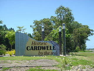
Cardwell is a tropical coastal town and locality in the Cassowary Coast Region in Far North Queensland, Australia. In the 2016 census, Cardwell had a population of 1,309 people. The Bruce Highway National Highway 1 and the North Coast railway line are the dominant transport routes; connecting with the Queensland provincial cities of Cairns and Townsville. Cardwell suffered significant damage from Cyclone Yasi, a category 5 cyclone, in February 2011.

Fantome Island island in Australia

Fantome Island is one of the islands in the Great Palm Island group. It is neighboured by Great Palm Island and is 65 km (40 mi) north-east of Townsville, Queensland on the east coast of Australia. The island is small with an area of 7.8 km2 (3.01 sq mi) and is surrounded by a fringing reef.

North Queensland Region in Queensland, Australia

North Queensland or the Northern Region is the northern part of the Australian state of Queensland that lies just south of Far North Queensland. Queensland is a massive state, larger than many countries, and the tropical northern part of it has been historically remote and undeveloped, resulting in a distinctive regional character and identity.

Alabama State Route 267 highway in Alabama

State Route 267 (SR 267) was a state highway in Alabama and a loop route of SR 147, bypassing downtown Auburn to the west. For its entire 5.1-mile (8.2 km) length, SR 267 was known as the Shug Jordan Parkway.

Shire of Johnstone Local government area in Queensland, Australia

The Shire of Johnstone was a local government area of Queensland. It was located on the Coral Sea coast about 90 kilometres (56 mi) south of the city of Cairns. The shire, administered from the town of Innisfail, covered an area of 1,639.1 square kilometres (632.9 sq mi), and existed as a local government entity from 1881 until 2008, when it amalgamated with the Shire of Cardwell to form the Cassowary Coast Region.

Shire of Cardwell Local government area in Queensland, Australia

The Shire of Cardwell was a local government area of Queensland. It was located on the Coral Sea coast about halfway between the cities of Cairns and Townsville. The shire, administered from the town of Tully, covered an area of 3,062.2 square kilometres (1,182.3 sq mi), and existed as a local government entity from 1884 until 2008, when it amalgamated with the Shire of Johnstone to form the Cassowary Coast Region.

Shire of Hinchinbrook Local government area in Queensland, Australia

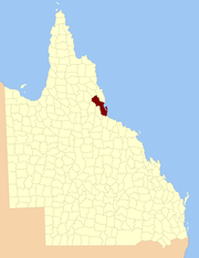
The Shire of Hinchinbrook is a local government area in North Queensland, Queensland, Australia. The shire, administered from the town of Ingham, covers an area of 2,807 square kilometres (1,083.8 sq mi), and has existed since its creation on 11 November 1879 as one of 74 divisions around Queensland under the Divisional Boards Act 1879.

South Townsville is a coastal suburb of the City of Townsville, Queensland, Australia.

Cassowary Coast Region Local government area in Queensland, Australia

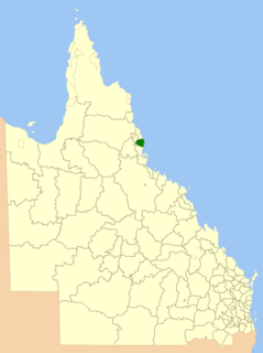
The Cassowary Coast Region is a local government area in the Far North Queensland region of Queensland, Australia, south of Cairns and centred on the towns of Innisfail, Cardwell and Tully. It was created in 2008 from a merger of the Shire of Cardwell and the Shire of Johnstone.

Charters Towers Region Local government area in Queensland, Australia

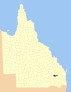
The Charters Towers Region is a local government area in North Queensland, Australia southwest of, and inland from the city of Townsville, based in Charters Towers. Established in 2008, it was preceded by two previous local government areas which dated back to the 1870s.

Oyster Point (Australia)

Oyster Point lies at the mouth of Stoney Creek, about one kilometre south of Cardwell in northern Australia.

The Suttor River is a river in Central Queensland, Australia. The Belyando River is its main tributary. The river has its origins in the Leichhardt Range, north west of Glenden. It flows into Lake Dalrymple, becoming a tributary of the Burdekin River.

County of March Cadastral in Queensland, Australia

The County of March is a county in Queensland, Australia. The county consists of the Noosa area, plus the eastern parts of the Gympie and Fraser Coast regions.

County of Fraser Cadastral in Queensland, Australia

The County of Fraser is one of 322 counties of Queensland, Australia, in the Wide Bay–Burnett region, which consists Fraser Island and some satellite islands off its southwestern coast. It was established on 7 March 1901 under the Land Act 1897, and borders County of March, which lies mainly on the Queensland mainland, but also includes Big Woody Island and other islands in the northern Great Sandy Strait.

County of Auburn Cadastral in Queensland, Australia

The County of Auburn is a county in the Darling Downs region of Queensland, Australia. Much of its area is within the Barakula State Forest. It was named and bounded by the Governor in Council on 7 March 1901 under the Land Act 1897.

Cardstone is a rural locality in the Cassowary Coast Region in Queensland, Australia. It is 50 kilometres (31 mi) south-west of Innisfail.

Kennedy, Queensland Suburb of Cassowary Coast Region, Queensland, Australia

Kennedy is a coastal locality in the Cassowary Coast Region, Queensland, Australia. In the 2016 census, Kennedy had a population of 161 people.

Murray Upper, Queensland Suburb of Cassowary Coast Region, Queensland, Australia

Murray Upper is a locality in the Cassowary Coast Region, Queensland, Australia.

References

  1. "Cardwell (entry 6215)". Queensland Place Names. Queensland Government . Retrieved 8 September 2015.
  2. North Kennedy District, County of Cardwell Maps – L2 Series at Queensland Archives.

Coordinates: 18°16′S146°02′E / 18.267°S 146.033°E / -18.267; 146.033