Courtney, Missouri

Last updated

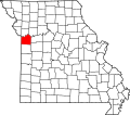
Courtney is an unincorporated community in Jackson County, in the U.S. state of Missouri. [1]

History

A post office called Courtney was established in 1888, and remained in operation until 1962. [2] The community has the name of C. C. Courtney, an early settler. [3]

Related Research Articles

<span class="mw-page-title-main">Turners, Missouri</span> Unincorporated community in the American state of Missouri

Turners or Turner is a small unincorporated community in Greene County, Missouri, United States. It lies on the southeast side of the James River floodplain approximately 3.5 miles east of U.S. Route 65 in east Springfield. The community lies at the intersection of Routes D and J near the confluence of Turner Creek with the James River. The old St. Louis–San Francisco Railway passed through the community.

Ohio is an unincorporated community in northern St. Clair County, in the U.S. state of Missouri. The community is at the intersection of Missouri routes A and F and south of Cooper Creek. Lowry City is on Missouri Route 13 approximately seven miles to the east and Appleton City is approximately nine miles to the west-northwest on Missouri Route 52.

Arley is an unincorporated community in Clay County, in the U.S. state of Missouri.

Hinch is an unincorporated community in eastern Crawford County, in the U.S. state of Missouri.

Glennonville is an unincorporated community in Dunklin County, in the U.S. state of Missouri.

Atherton is an unincorporated community in Jackson County, in the U.S. state of Missouri.

Blue Mills is an unincorporated community in Jackson County, in the U.S. state of Missouri.

Cockrell is an unincorporated community in Jackson County, in the U.S. state of Missouri.

Hicks City is an unincorporated community in Jackson County, in the U.S. state of Missouri.

Hiler is an unincorporated community in Jackson County, in the U.S. state of Missouri.

Leeds is a neighborhood of Kansas City, Missouri, United States.

Pink Hill is an unincorporated community in Jackson County, in the U.S. state of Missouri. It is located on Pink Hill Road roughly between South Howell Road and South Fields Road.

Ripley is a neighborhood of Independence, Missouri, United States.

Sheffield is a neighborhood of Kansas City, Missouri, United States.

Sni Mills is an unincorporated community in Jackson County, in the U.S. state of Missouri.

Tarsney is an unincorporated community in Jackson County, in the U.S. state of Missouri.

Blue Township is an inactive township in Jackson County, in the U.S. state of Missouri.

Fort Osage Township is an inactive township in Jackson County, in the U.S. state of Missouri.

Sni-A-Bar Township is an inactive township in Jackson County, in the U.S. state of Missouri.

Saint Anthony is an unincorporated community in eastern Miller County, in the U.S. state of Missouri. The community is located on Missouri Route A, west of Missouri Route 42 and above Tavern Creek. Brays is on Route 42 to the east and Iberia is 5.5 miles to the south-southwest.

References

  1. U.S. Geological Survey Geographic Names Information System: Courtney, Missouri
  2. "Post Offices". Jim Forte Postal History. Archived from the original on October 13, 2016. Retrieved October 16, 2016.
  3. "Jackson County Place Names, 1928–1945 (archived)". The State Historical Society of Missouri. Archived from the original on June 24, 2016. Retrieved October 16, 2016.{{cite web}}: CS1 maint: bot: original URL status unknown (link)

39°09′20″N94°23′37″W / 39.15556°N 94.39361°W / 39.15556; -94.39361