Tarsney Lakes, Missouri | |
|---|---|
 Tarsney Lakes  Tarsney Lakes | |
| Coordinates: 38°56′59″N94°12′15″W / 38.94972°N 94.20417°W | |
| Country | United States |
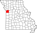
| State | Missouri |
| County | Jackson |
| Township | Van Buren |
| Area | |
• Total | 0.36 sq mi (0.92 km2) |
| • Land | 0.31 sq mi (0.79 km2) |
| • Water | 0.05 sq mi (0.13 km2) |
| Elevation | 939 ft (286 m) |
| Population (2020) | |
• Total | 250 |
| • Density | 816.99/sq mi (315.67/km2) |
| Time zone | UTC-6 (Central (CST)) |
| • Summer (DST) | UTC-5 (CDT) |
| ZIP Code | 64075 (Oak Grove) |
| Area code | 816 |
| FIPS code | 29-72412 |
| GNIS feature ID | 2806404 [2] |
Tarsney Lakes is an unincorporated community and census-designated place (CDP) in Jackson County, Missouri, United States. It is in the eastern part of the county, northeast of the unincorporated community of Tarsney, and consisting of residential neighborhoods surrounding Tarsney Lake and Wood Lake, just south of the West Fork of Sni-A-Bar Creek. It is 28 miles (45 km) southeast of downtown Kansas City.
Contents
Tarsney Lakes was first listed as a CDP prior to the 2020 census. [2]