Unity Village, Missouri | |
|---|---|
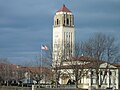
 Unity Village Campus | |
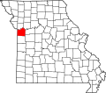
 Location of Unity Village, Missouri | |
 U.S. Census Map | |
| Coordinates: 38°56′47″N94°23′58″W / 38.94639°N 94.39944°W | |
| Country | United States |
| State | Missouri |
| County | Jackson |
| Area | |
• Total | 1.53 sq mi (3.95 km2) |
| • Land | 1.46 sq mi (3.78 km2) |
| • Water | 0.066 sq mi (0.17 km2) |
| Elevation | 935 ft (285 m) |
| Population (2020) | |
• Total | 66 |
| • Density | 45.2/sq mi (17.46/km2) |
| Time zone | UTC-6 (Central (CST)) |
| • Summer (DST) | UTC-5 (CDT) |
| ZIP codes | 64065 |
| Area code | 816 |
| FIPS code | 29-75202 [2] |
| GNIS feature ID | 0728064 [3] |
| Website | unityvillage |
Unity Village is a village in Jackson County, Missouri, United States, bordering Kansas City and Lee's Summit. It is part of the Kansas City metropolitan area. Its population was 66 at the 2020 census. The founders of the Unity spiritual movement, Charles and Myrtle Fillmore, purchased a 58-acre (23 ha) farm in 1919 as a weekend getaway for employees of their downtown Kansas City headquarters. In March 1920, the land came to be known as Unity Farm, and the following purchase of 12 surrounding farms expanded the land to nearly 1,500 acres. [4]
Contents
The farm produced fruits and vegetables, including 7,500 apple trees, a 400-tree peach orchard, 12 acres of grapevines, cherry and plum trees, and fields of oats, corn, wheat, strawberries, asparagus, and soybeans. Unity Farm also supported a poultry house containing 2,000 white leghorn hens, whose eggs helped sustain a meatless menu at the Unity Inn cafeteria downtown.
The Fillmores’ work was consolidated at Unity Village after World War II, and it is now the world headquarters for the ongoing spiritual movement. On March 15, 1953, the State of Missouri officially incorporated the land as Unity Village. In the 2010 census, its population was 99.
The Unity Village is a campus with historic buildings. The grounds dwellings in the English Cotswold style as well as Mediterranean-inspired buildings designed by Waldo Rickert Fillmore (also known as Rickert), the second son of Charles and Myrtle Fillmore. The Tower and an office building then used for the Silent Unity Prayer Ministry opened in 1929 and are on the National Register of Historic Places.
Unity Village is also home to two artificial lakes. Lake Charles R. Fillmore (named for the grandson of the Unity cofounders) was created in 1926 to supply water to the farm and orchard that Unity maintained until the 1980s. A crew of 100 men built a concrete buttress dam, the only one of its kind in Missouri and one of the few west of the Mississippi River, at a cost of $100,000 to form the lake. The lake is 42 feet deep and covers 21 surface acres, holding about 75 million gallons of water. It remains the primary water supply for the Village today, and its water is pumped to the on-campus water treatment plant.