Covada, Washington | |
|---|---|
 Covada  Covada | |
| Coordinates: 48°13′14″N118°12′32″W / 48.22056°N 118.20889°W | |
| Country | United States |
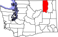
| State | Washington |
| County | Ferry |
| Established | 1905 |
| Elevation | 1,880 ft (570 m) |
| Time zone | UTC-8 (Pacific (PST)) |
| • Summer (DST) | UTC-7 (PDT) |
| Area code | 509 |
| GNIS feature ID | 1510892 [1] |
Covada is an unincorporated community in Ferry County, in the U.S. state of Washington. [1]