Twin Lakes, Washington | |
|---|---|
 Twin Lakes  Twin Lakes | |
| Coordinates: 48°15′44″N118°22′05″W / 48.26222°N 118.36806°W [1] | |
| Country | United States |
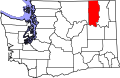
| State | Washington |
| County | Ferry |
| Area | |
• Total | 4.2 sq mi (10.8 km2) |
| • Land | 4.2 sq mi (10.8 km2) |
| • Water | 0.0 sq mi (0.0 km2) |
| Elevation | 2,592 ft (790 m) |
| Population (2010) | |
• Total | 59 |
| • Density | 14/sq mi (5.5/km2) |
| Time zone | Pacific |
| ZIP code | 99138 [2] |
| Area code | 360 |
| GNIS feature ID | 2585047 [1] |
Twin Lakes is a census-designated place in Ferry County, Washington, United States.