Barstow, Washington | |
|---|---|
 Barstow  Barstow | |
| Coordinates: 48°46′42″N118°07′43″W / 48.77833°N 118.12861°W [1] | |
| Country | United States |
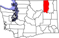
| State | Washington |
| County | Ferry |
| Area | |
• Total | 0.56 sq mi (1.45 km2) |
| • Land | 0.56 sq mi (1.45 km2) |
| • Water | 0.0 sq mi (0.0 km2) |
| Elevation | 1,388 ft (423 m) |
| Population (2010) | |
• Total | 59 |
| • Density | 105/sq mi (40.7/km2) |
| ZIP code | 99141 [2] |
| Area code | 509 |
| GNIS feature ID | 2631208 [1] |
Barstow is a census-designated place (CDP) and unincorporated community in Ferry County in the U.S. state of Washington. As of the 2010 census it had a population of 59. [3]