Yazoo County is a county located in the U.S. state of Mississippi. As of the 2020 census, the population was 26,743. The county seat is Yazoo City. It is named for the Yazoo River, which forms its western border. Its name is said to come from a Choctaw language word meaning "River of Death."

Madison County is a county located in the U.S. state of Mississippi. As of the 2020 census, the population was 109,145. The county seat is Canton. The county is named for Founding Father and U.S. President James Madison.

Durant is a city near the central eastern border of Holmes County, Mississippi, United States, and Big Black River. The town was founded in 1858 as a station on the Mississippi Central Railroad, later part of the Illinois Central. Durant was named for Louis Durant, a Choctaw chief who had lived on this site before the United States undertook Indian Removal in the 1830s, forcing him and most of the Choctaw to Indian Territory west of the Mississippi River.

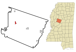
Lexington is a city in and the county seat of Holmes County, Mississippi, United States. The county was organized in 1833 and the city in 1836. The population was 1,731 at the 2010 census, down from 2,025 at the 2000 census. The estimated population in 2018 was 1,496. It has declined from its high of 3,198 in 1950 due to the expansion of industrial-scale agriculture.

Pickens is a town in Holmes County, Mississippi, United States. Per the 2020 census, the population was 920.
Tchula is a town in Holmes County, Mississippi, United States. The population was 1,650 at the 2020 census, down from 2,332 in 2000.
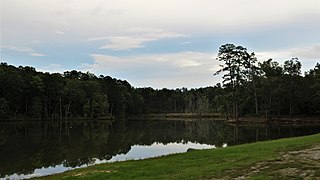
Holmes County State Park is a state park in the U.S. state of Mississippi located off U.S. Route 51 approximately 4 miles (6.4 km) south of Durant. The park features two lakes, 45-acre (18 ha) English Lake and 14-acre (5.7 ha) Odum Lake.
Caile is an unincorporated community located in Sunflower County, Mississippi in the Mississippi Delta. Caile is located on U.S. Route 49W approximately 3 miles (4.8 km) north of Isola and approximately 3 miles (4.8 km) south of Inverness.

Winterville is a census-designated place and unincorporated community located in Washington County, Mississippi, near Mississippi Highway 1. Winterville is approximately 3 miles (4.8 km) north of Greenville, the county seat, and approximately 4 miles (6.4 km) south of Lamont.

Thornton, Mississippi is an unincorporated community located in Holmes County, near the Yazoo River. U.S. Highway 49E runs through the community, which is approximately 7 miles (11 km) north of Eden and approximately 10 miles (16 km) south of Tchula.

Marcella is an unincorporated community located in Holmes County, Mississippi near the Yazoo River. Marcella is located near Mississippi Highway 12 and is approximately 5 miles (8.0 km) north of Thornton, and approximately 9 miles (14 km) south of Tchula.
Tolarville is an unincorporated community located in Holmes County, Mississippi, located approximately 5 miles (8.0 km) east of Thornton and approximately 9 miles (14 km) north of Coxburg. A post office operated under the name Tolarville from 1888 to 1914.
Acona is an unincorporated community located in Holmes County, Mississippi. Acona is located on Mississippi Highway 17 and is approximately 12 miles (19 km) north of Lexington and approximately 4 miles (6.4 km) south of Black Hawk.
Howard is an unincorporated community located in Holmes County, Mississippi and is approximately 5 miles (8.0 km) south of Tchula. The community was once a stop on the Yazoo and Mississippi Valley Railroad. Howard was incorporated in 1888 but lost that status at an unknown date. A post office operated under the name Howard from 1887 to 1920.

Franklin is an unincorporated community located in Holmes County, Mississippi. Mississippi Highway 17 passes through Franklin, which is approximately 7 miles (11 km) south of Lexington, the county seat, and approximately 12 miles (19 km) north of the town of Pickens.

Owens Wells is an unincorporated community in Holmes County, Mississippi, United States. Owens Wells is located near Mississippi Highway 12 and is approximately 6 miles (9.7 km) east of Lexington and approximately 8 miles (13 km) west of Durant. The community was once a stop on the Yazoo and Mississippi Valley Railroad.
Ituma is an unincorporated community located in Holmes County, Mississippi. Ituma is approximately 7 miles (11 km) southwest of Acona and approximately 10 miles (16 km) northeast of Tchula.

Richland is an unincorporated community in Holmes County, Mississippi, located approximately 4 miles (6.4 km) northwest of Goodman and approximately 7 miles (11 km) north of Pickens.
Brownsville is an unincorporated community located on Mississippi Highway 22 in northern Hinds County, Mississippi. Brownsville is approximately 12 miles (19 km) southwest of Flora and approximately 8 miles (13 km) north of Bolton.

Mileston is an unincorporated community located in Holmes County, Mississippi. Mileston is located on U.S. Highway 49E and Highway 12, approximately 6 miles (9.7 km) south of Tchula, approximately 4 miles (6.4 km) north of Thornton and approximately 3 miles (4.8 km) southeast of Marcella.