
Breckland in Norfolk and Suffolk is a 39,433 hectare Special Protection Area (SPA) under the European Union Directive on the Conservation of Wild Birds. The SPA partly overlaps the 7,544 hectare Breckland Special Area of Conservation. As a landscape region it is an unusual natural habitat of England. It comprises the gorse-covered sandy heath that lies mostly in the south of the county of Norfolk but also in the north of Suffolk. An area of considerable interest for its unusual flora and fauna, it lies to the east of another unusual habitat, the Fens, and to the south west of the Broads. The typical tree of this area is the Scots pine. Breckland is one of the driest areas in England.
Hockham Mere is the site of a former lake, >400 metres diameter, in Norfolk, England. Its biogenic sediments contain a late-Devensian & Holocene pollen record.

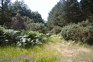
Great Eastern Pingo Trail is 9.2 kilometres long footpath along a disused railway line north of Thetford in Norfolk. It is a 4.2-hectare (10-acre) Local Nature Reserve, and it crosses three Sites of Special Scientific Interest, Thompson Water, Carr and Common, Breckland Forest and Cranberry Rough, Hockham. It also crosses Thompson Common, which is a nature reserve managed by the Norfolk Wildlife Trust and is a Nature Conservation Review site, Grade I. It further crosses Norfolk Valley Fens Special Area of Conservation and Breckland Special Protection Area.

Thompson Water, Carr and Common is a 154.7-hectare (382-acre) biological Site of Special Scientific Interest north of Thetford in Norfolk, England. Most of it is managed by the Norfolk Wildlife Trust as Thompson Common. It is a Nature Conservation Review site, Grade I, and part of the Norfolk Valley Fens Special Area of Conservation. It is crossed by the Great Eastern Pingo Trail Local Nature Reserve.

East Wretham Heath is a 141.1-hectare (349-acre) biological Site of Special Scientific Interest south-east of Thetford in Norfolk, England. It is a Nature Conservation Review site, Grade I, and it is managed by the Norfolk Wildlife Trust. it is part of the Breckland Special Area of Conservation and Special Protection Area.

Weeting Heath is a 141.8-hectare (350-acre) biological Site of Special Scientific Interest west of Thetford in Norfolk, England, which is managed by the Norfolk Wildlife Trust. It is a Nature Conservation Review site, Grade I, and a National Nature Reserve. It is also part of the Breckland Special Area of Conservation and Special Protection Area.
Breckland Forest is an 18,126 hectare biological and geological Site of Special Scientific Interest in many separate areas between Swaffham in Norfolk and Bury St Edmunds in Suffolk, England. It is part of the Breckland Special Protection Area under the European Union Directive on the Conservation of Wild Birds. It contains two Geological Conservation Review sites, Beeches Pit, Icklingham and High Lodge. Barton Mills Valley is a Local Nature Reserve in the south-west corner of the site.

Cavenham–Icklingham Heaths is a 419 hectare biological Site of Special Scientific Interest west of Icklingham in Suffolk. It is a Nature Conservation Review site, Grade I, and part of Breckland Special Area of Conservation and Breckland Special Protection Area under the European Union Directive on the Conservation of Wild Birds. Cavenham Heath is a 203.1 hectare National Nature Reserve.

Deadman's Grave, Icklingham is a 127.3-hectare (315-acre) biological Site of Special Scientific Interest north-east of Icklingham in Suffolk. It is a Nature Conservation Review site, Grade I, and part of Breckland Special Area of Conservation and Breckland Special Protection Area under the European Union Directive on the Conservation of Wild Birds.

Thetford Heaths is a 270.6-hectare (669-acre) biological and geological Site of Special Scientific Interest in Suffolk. It is a Nature Conservation Review site, Grade I, and parts of it are a national nature reserve, and a Geological Conservation Review, It is part of the Breckland Special Area of Conservation, and Special Protection Area A large part of this dry heathland site is calcareous grassland, and some areas are grazed by sheep or rabbits. There are several nationally rare plants and an uncommon heathland bird, and many lichens and mosses.

Barnham Cross Common is a 69.1-hectare (171-acre) biological Site of Special Scientific Interest on the southern outskirts of Thetford in Norfolk, England. It is owned by Thetford Town Council and is registered common land. It is also a Local Nature Reserve and a Nature Conservation Review site, Grade 1. It is part of the Breckland Special Area of Conservation and Special Protection Area.

Bridgham and Brettenham Heaths is a 439.9-hectare (1,087-acre) biological Site of Special Scientific Interest north-east of Thetford in Norfolk, England. It is a Nature Conservation Review site, Grade I, and part of the Breckland Special Area of Conservation and Special Protection Area. Brettenham Heath is a National Nature Reserve.

Morston Cliff is a 1-hectare (2.5-acre) geological Site of Special Scientific Interest east of Wells-next-the-Sea in Norfolk, England. It is a Geological Conservation Review site. It is part of Blakeney National Nature Reserve, which is managed by the National Trust, and of the Norfolk Coast Area of Outstanding Natural Beauty.
Stanford Training Area SSSI is part of the British Army Stanford Training Area. It is a 4,678-hectare (11,560-acre) biological and geological Site of Special Scientific Interest north of Thetford in Norfolk, England. It is a Nature Conservation Review site and part of it is a Geological Conservation Review site. It is also part of the Breckland Special Area of Conservation and Special Protection Area.

Thetford Golf Course and Marsh is a 122.3-hectare (302-acre) biological Site of Special Scientific Interest on the western outskirts of Thetford in Norfolk, England. It is a Nature Conservation Review site, Grade 2, and part of the Breckland Special Area of Conservation and Special Protection Area.

Upper Thurne Broads and Marshes is a 1,185.9-hectare (2,930-acre) biological Site of Special Scientific Interest north of Great Yarmouth in Norfolk, England. Part of it is a Nature Conservation Review site, Grade I, and it is in the Norfolk Coast Area of Outstanding Natural Beauty. It is part of the Broadland Ramsar site and Special Protection Area, and The Broads Special Area of Conservation. Two areas, Hickling Broad and Martham Broad, are national nature reserves managed by the Norfolk Wildlife Trust.

Wretton SSSI is a 20.6-hectare (51-acre) geological Site of Special Scientific Interest north-east of Downham Market in Norfolk, England. It is a Geological Conservation Review site.

Gooderstone Warren is a 21.6-hectare (53-acre) biological Site of Special Scientific Interest south of Cockley Cley in Norfolk, England. It is part of the Breckland Special Area of Conservation and Special Protection Area.
