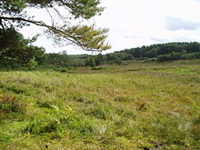
Great Eastern Pingo Trail is 9.2 kilometres long footpath along a disused railway line north of Thetford in Norfolk. It is a 4.2-hectare (10-acre) Local Nature Reserve, and it crosses three Sites of Special Scientific Interest, Thompson Water, Carr and Common, Breckland Forest and Cranberry Rough, Hockham. It also crosses Thompson Common, which is a nature reserve managed by the Norfolk Wildlife Trust and is a Nature Conservation Review site, Grade I. It further crosses Norfolk Valley Fens Special Area of Conservation and Breckland Special Protection Area.

Dersingham Bog is a 159.1-hectare (393-acre) biological and geological Site of Special Scientific Interest in Norfolk, England. It is a Nature Conservation Review site, Grade 2, a National Nature Reserve and a Ramsar site It is part of the Norfolk Coast Area of Outstanding Natural Beauty, and the Roydon Common & Dersingham Bog Special Area of Conservation Part of it is a Geological Conservation Review site.

Thompson Water, Carr and Common is a 154.7-hectare (382-acre) biological Site of Special Scientific Interest north of Thetford in Norfolk, England. Most of it is managed by the Norfolk Wildlife Trust as Thompson Common. It is a Nature Conservation Review site, Grade I, and part of the Norfolk Valley Fens Special Area of Conservation. It is crossed by the Great Eastern Pingo Trail Local Nature Reserve.
Buxton Heath is a 67.3-hectare (166-acre) biological Site of Special Scientific Interest north of Norwich in Norfolk, England. It is a Nature Conservation Review site, Grade 2, and part of the North Valley Fens Special Area of Conservation.

East Wretham Heath is a 141.1-hectare (349-acre) biological Site of Special Scientific Interest south-east of Thetford in Norfolk, England. It is a Nature Conservation Review site, Grade I, and it is managed by the Norfolk Wildlife Trust. it is part of the Breckland Special Area of Conservation and Special Protection Area.

Weeting Heath is a 141.8-hectare (350-acre) biological Site of Special Scientific Interest west of Thetford in Norfolk, England, which is managed by the Norfolk Wildlife Trust. It is a Nature Conservation Review site, Grade I, and a National Nature Reserve. It is also part of the Breckland Special Area of Conservation and Special Protection Area.

Roydon Common is a 194.9-hectare (482-acre) biological Site of Special Scientific Interest east of King's Lynn in Norfolk, England. It is also a Grade I Nature Conservation Review site, a National Nature Reserve and a Ramsar site. It is part of the Roydon Common and Dersingham Bog Special Area of Conservation and Roydon Common and Grimston Warren nature reserve, which is managed by the Norfolk Wildlife Trust,

Ant Broads and Marshes is a 745.3-hectare (1,842-acre) biological Site of Special Scientific Interest north-east of Norwich in Norfolk, England. Most of it is a Nature Conservation Review site, Grade 1, and it is part of the Broadland Ramsar and Special Protection Area, and The Broads Special Area of Conservation. Part of it is the Barton Broad nature reserve, which is managed by the Norfolk Wildlife Trust, and two areas are National Nature Reserves.

Booton Common is an 8.2-hectare (20-acre) biological Site of Special Scientific Interest north-west of Norwich in Norfolk, England. It is managed by the Norfolk Wildlife Trust and is a Special Area of Conservation

Bridgham and Brettenham Heaths is a 439.9-hectare (1,087-acre) biological Site of Special Scientific Interest north-east of Thetford in Norfolk, England. It is a Nature Conservation Review site, Grade I, and part of the Breckland Special Area of Conservation and Special Protection Area. Brettenham Heath is a National Nature Reserve.
East Walton and Adcock's Common is a 62.4-hectare (154-acre) biological and geological Site of Special Scientific Interest south-east of King's Lynn in Norfolk, England. It is a Geological Conservation Review site and part of Norfolk Valley Fens Special Area of Conservation

Foulden Common is a 139-hectare (340-acre) biological Site of Special Scientific Interest east of Downham Market in Norfolk, England. It is a Nature Conservation Review site, Grade 2, and part of the Norfolk Valley Fens Special Area of Conservation.

Potter and Scarning Fens, East Dereham is a 6.2-hectare (15-acre) biological Site of Special Scientific Interest south of Dereham in Norfolk, England. It is part of the Norfolk Valley Fens Special Area of Conservation. Scarning Fen is a Nature Conservation Review site, Grade I, and it is managed by the Norfolk Wildlife Trust.

Sheringham and Beeston Regis Commons is a 24.9-hectare (62-acre) biological Site of Special Scientific Interest in Sheringham in Norfolk, England. It is a Nature Conservation Review site and part of the Norfolk Valley Fens Special Area of Conservation and Norfolk Coast Area of Outstanding Natural Beauty.

Southrepps Common is a 5.6-hectare (14-acre) biological Site of Special Scientific Interest north of North Walsham in Norfolk, England. A larger area of 12.9-hectare (32-acre) is a Local Nature Reserve. It is owned by Southrepps Parish Council and managed by Southrepps Common Group. It is part of the Norfolk Valley Fens Special Area of Conservation.

Yare Broads and Marshes is a 744.5-hectare (1,840-acre) biological Site of Special Scientific Interest east of Norwich in Norfolk, England. Part of the site is a Nature Conservation Review site, Grade I and most of it is in the Mid-Yare National Nature Reserve. It is part of the Broadland Ramsar site and Special Protection Area, and The Broads Special Area of Conservation. Two ares are Royal Society for the Protection of Birds nature reserves, Strumpshaw Fen and Surlingham Church Marsh.
Scarning Fen is a 4-hectare (9.9-acre) nature reserve west in Dereham in Norfolk. It is managed by the Norfolk Wildlife Trust. It is a Nature Conservation Review site, Grade I, and is part of Potter and Scarning Fens Site of Special Scientific Interest and Norfolk Valley Fens Special Area of Conservation.
Smallburgh Fen is a 7.6-hectare (19-acre) biological Site of Special Scientific Interest in Smallburgh in Norfolk, United Kingdom. It is part of the Broadland Ramsar site and Special Protection Area, and The Broads Special Area of Conservation. It is also a Nature Conservation Review site, Grade 2.