
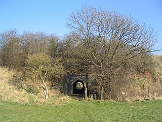
The Marriott's Way is a footpath, cycle-path and bridleway in north Norfolk, England, between Norwich and Aylsham via Themelthorpe. It forms part of the National Cycle Network (NCN) and the red route of Norwich's Pedalways cycle path network. It is open to walkers, cyclists and horse riders. Its total length is 24.6 miles (39.5 km). It has a mixture of surfaces: tarmac, compacted gravel and earth. The name of the route originates from the chief engineer and manager of the Midland and Great Northern Joint Railway (M&GNJR), William Marriott, who held the position for 41 years.

Ouse Washes is a linear 2,513.6-hectare (6,211-acre) biological Site of Special Scientific Interest stretching from near St Ives in Cambridgeshire to Downham Market in Norfolk, England. It is also a Ramsar internationally important wetland site, a Special Protection Area for birds, a Special Area of Conservation and a Nature Conservation Review site, Grade I. An area of 186 hectares between March and Ely is managed by the Wildlife Trust for Bedfordshire, Cambridgeshire and Northamptonshire and another area near Chatteris is managed by the Royal Society for the Protection of Birds. The Wildfowl & Wetlands Trust manages another area near Welney.
Loughborough Meadows is a 60.5 hectares biological Site of Special Scientific Interest on the northern outskirts of Loughborough in Leicestershire, England. An area of 35.3 hectares is managed as a nature reserve by the Leicestershire and Rutland Wildlife Trust.
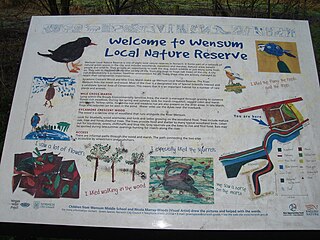
Wensum Local Nature Reserve or Wensum Valley is a Local Nature Reserve in Norwich in the English county of Norfolk. The reserve consists of two sites; Mile Cross Marsh52.6419°N 1.2657°E and Sycamore Crescent Wood which are linked by the Riverside Path a public footpath via the Sycamore Crescent footbridge

Sizewell Marshes form a 260-acre biological Site of Special Scientific Interest adjacent to Sizewell in Suffolk. It is in the Suffolk Coast and Heaths Area of Outstanding Natural Beauty, and is part of a 356-acre (144-ha) nature reserve managed by the Suffolk Wildlife Trust as Sizewell Belts.
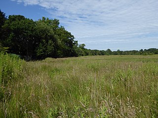
Hoe Rough is a 12-hectare (30-acre) nature reserve north of Dereham in Norfolk. It is managed by the Norfolk Wildlife Trust, and is part of the Beetley and Hoe Meadows Site of Special Scientific Interest.

Long Herdon Meadow is a 4.5-hectare (11-acre) biological Site of Special Scientific Interest south of Marsh Gibbon in Buckinghamshire. It is part of Upper Ray Meadows nature reserve, which is managed by the Berkshire, Buckinghamshire and Oxfordshire Wildlife Trust.

Ulverscroft Valley is a 110.8-hectare (274-acre) biological Site of Special Scientific Interest north-west of Markfield in Leicestershire. The site is in five separate blocks, and two areas are nature reserves managed by the Leicestershire and Rutland Wildlife Trust (LRWT). Lea Meadows is owned by the LRWT and it is also a scheduled monument. Part of Ulverscroft Nature Reserve is owned by the LRWT and part is owned by the National Trust and leased to the LRWT.

Ulverscroft is a 56-hectare (140-acre) nature reserve north of Markfield in Leicestershire, England. It is managed by the Leicestershire and Rutland Wildlife Trust, which shares its ownership with the National Trust. The site is partly in Ulverscroft Valley, which is a Site of Special Scientific Interest.

Beetley and Hoe Meadows is an 11.4-hectare (28-acre) biological Site of Special Scientific Interest north of Dereham in Norfolk, United Kingdom. The site is in two nearby areas, and Hoe Meadow is part of Hoe Rough nature reserve, which is managed by the Norfolk Wildlife Trust

Booton Common is an 8.2-hectare (20-acre) biological Site of Special Scientific Interest north-west of Norwich in Norfolk, England. It is managed by the Norfolk Wildlife Trust and is a Special Area of Conservation
Shotesham Common is a 21.6-hectare (53-acre) biological Site of Special Scientific Interest south of Norwich in Norfolk, England.
Crostwick Marsh is an 11.6-hectare (29-acre) biological Site of Special Scientific Interest in Crostwick, north of Norwich in Norfolk, England. It is part of the Broadland Ramsar site and Special Protection Area, and The Broads Special Area of Conservation.

Swangey Fen, Attleborough is a 48.4-hectare (120-acre) biological Site of Special Scientific Interest south-west of Attleborough in Norfolk, England. It is part of the Norfolk Valley Fens Special Area of Conservation.

Holly Farm Meadow, Wendling is a 2.6-hectare (6.4-acre) biological Site of Special Scientific Interest west of Dereham in Norfolk, England.

Dereham Rush Meadow is a 22.2-hectare (55-acre) biological Site of Special Scientific Interest north-west of Dereham in Norfolk, England.
Hollybed Farm Meadows is nature reserve of the Worcestershire Wildlife Trust, about 1 mile (1.6 km) west of the village of Castlemorton, in Worcestershire, England. The habitat is grassland.

