
Bilsey Hill is a 3-hectare (7.4-acre) geological Site of Special Scientific Interest south of Blakeney in Norfolk, England. It is a Geological Conservation Review site and it is in the Norfolk Coast Area of Outstanding Natural Beauty.
The Norfolk Coast National Landscape or Norfolk Coast Protected Landscape is a protected National Landscape in Norfolk, England. It covers over 450 km2 of coastal and agricultural land from The Wash in the west through coastal marshes and cliffs to the sand dunes at Winterton in the east. It was designated an Area of Outstanding Natural Beauty (AONB) in 1968, under the National Parks and Access to the Countryside Act 1949.

Dersingham Bog is a 159.1-hectare (393-acre) biological and geological Site of Special Scientific Interest in Norfolk, England. It is a Nature Conservation Review site, Grade 2, a National Nature Reserve and a Ramsar site It is part of the Norfolk Coast Area of Outstanding Natural Beauty, and the Roydon Common & Dersingham Bog Special Area of Conservation Part of it is a Geological Conservation Review site.

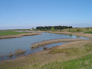
Salthouse Marshes is a 66-hectare (160-acre) nature reserve west of Sheringham in Norfolk. It is managed by the Norfolk Wildlife Trust. It is part of the North Norfolk Coast Site of Special Scientific Interest, Geological Conservation Review site, Nature Conservation Review site, Grade I. Ramsar site, Special Areas of Conservation and Special Protection Area. It is also in the Norfolk Coast Area of Outstanding Natural Beauty.
Holme Dunes is a 192-hectare (470-acre) nature reserve near Holme-next-the-Sea in Norfolk. It is managed by the Norfolk Wildlife Trust, and is a National Nature Reserve. It is part of the North Norfolk Coast Site of Special Scientific Interest, Geological Conservation Review site, Nature Conservation Review site, Grade I, Ramsar site, Special Areas of Conservation and Special Protection Area. It is also in the Norfolk Coast Area of Outstanding Natural Beauty.

Bawdsey Cliff is a 17.4-hectare (43-acre) geological Site of Special Scientific Interest north-east of Felixstowe in Suffolk. It is a Geological Conservation Review site, and is in the Suffolk Coast and Heaths Area of Outstanding Natural Beauty.

Ramsholt Cliff is a 2.1-hectare (5.2-acre) geological Site of Special Scientific Interest north-west of Ramsholt in Suffolk. It is a Geological Conservation Review site, and it is in the Suffolk Coast and Heaths Area of Outstanding Natural Beauty.

Holkham Brick Pit is a 0.5-hectare (1.2-acre) geological Site of Special Scientific Interest west of Wells-next-the-Sea in Norfolk, England. It is a Geological Conservation Review site, and it is in the Norfolk Coast Area of Outstanding Natural Beauty.

Morston Cliff is a 1-hectare (2.5-acre) geological Site of Special Scientific Interest east of Wells-next-the-Sea in Norfolk, England. It is a Geological Conservation Review site. It is part of Blakeney National Nature Reserve, which is managed by the National Trust, and of the Norfolk Coast Area of Outstanding Natural Beauty.

Wells Chalk Pit is a 4-hectare (9.9-acre) biological and geological Site of Special Scientific Interest on the eastern outskirts of Wells-next-the-Sea in Norfolk, England. It is a Geological Conservation Review site, and it is in the Norfolk Coast Area of Outstanding Natural Beauty.

Felbrigg Woods is a 164.6-hectare (407-acre) biological Site of Special Scientific Interest south-west of Cromer in Norfolk, England. It is the main part of the grounds of Felbrigg Hall, a National Trust property which is listed on the Register of Historic Parks and Gardens of Special Historic Interest in England. It is a Nature Conservation Review site, Grade 2, and it is in the Norfolk Coast Area of Outstanding Natural Beauty.

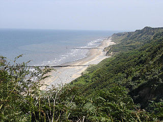
Sidestrand and Trimingham Cliffs is a 133.9-hectare (331-acre) biological and geological Site of Special Scientific Interest south-east of Cromer in Norfolk, England. It is a Geological Conservation Review site. It is in the Norfolk Coast Area of Outstanding Natural Beauty.

Weybourne Cliffs is a 40.9-hectare (101-acre) biological and geological Site of Special Scientific Interest at Weybourne, west of Sheringham in the English county of Norfolk. It is a Geological Conservation Review site. It is in the Norfolk Coast Area of Outstanding Natural Beauty.

Winterton-Horsey Dunes is a 427-hectare (1,060-acre) biological and geological Site of Special Scientific Interest north of Great Yarmouth in Norfolk, England. It is a Special Area of Conservation and a Nature Conservation Review site, Grade I. Winterton Dunes is a National Nature Reserve Winterton Ness is a Geological Conservation Review site. The whole site is in the Norfolk Coast Area of Outstanding Natural Beauty.

Wiveton Downs is a 28.9-hectare (71-acre) biological and geological Site of Special Scientific Interest at Wiveton, west of Sheringham in the English county of Norfolk. Part of it is a Geological Conservation Review site, and an area of 6.5-hectare (16-acre) is a Local Nature Reserve. It is in the Norfolk Coast Area of Outstanding Natural Beauty.

Briton's Lane Gravel Pit is a 21.5-hectare (53-acre) geological Site of Special Scientific Interest east of Sheringham in Norfolk, England. It is a Geological Conservation Review site and it is in the Norfolk Coast Area of Outstanding Natural Beauty.

Glandford (Hurdle Lane) is a 9.4-hectare (23-acre) geological Site of Special Scientific Interest west of Sheringham in Norfolk, England. It is a Geological Conservation Review site and it is in the Norfolk Coast Area of Outstanding Natural Beauty.

Glandford (Letheringsett Road) is a 1.1-hectare (2.7-acre) geological Site of Special Scientific Interest west of Sheringham in Norfolk, England. It is a Geological Conservation Review site and it is in the Norfolk Coast Area of Outstanding Natural Beauty.
Weybourne Town Pit is a 0.7-hectare (1.7-acre) geological Site of Special Scientific Interest west of Sheringham in Norfolk, England. It is a Geological Conservation Review site and it is in the Norfolk Coast Area of Outstanding Natural Beauty.
