Roydon Common

Last updated
Roydon Common
Site of Special Scientific Interest
Entrance to Roydon Common, Norfolk. - geograph.org.uk - 161880.jpg
Area of Search Norfolk
Grid reference TF 686 224 [1]
Interest Biological
Area 194.9 hectares (482 acres) [1]
Notification 1984 [1]
Location map Magic Map

Roydon Common is a 194.9-hectare (482-acre) biological Site of Special Scientific Interest east of King's Lynn in Norfolk. [1] [2] It is also a Grade I Nature Conservation Review site, [3] a National Nature Reserve [4] and a Ramsar site. [5] It is part of the Roydon Common and Dersingham Bog Special Area of Conservation [6] and Roydon Common and Grimston Warren nature reserve, which is managed by the Norfolk Wildlife Trust, [7]

Site of Special Scientific Interest conservation designation denoting a protected area in the United Kingdom

A Site of Special Scientific Interest (SSSI) in Great Britain or an Area of Special Scientific Interest (ASSI) in the Isle of Man and Northern Ireland is a conservation designation denoting a protected area in the United Kingdom and Isle of Man. SSSI/ASSIs are the basic building block of site-based nature conservation legislation and most other legal nature/geological conservation designations in the United Kingdom are based upon them, including national nature reserves, Ramsar sites, Special Protection Areas, and Special Areas of Conservation. The acronym "SSSI" is often pronounced "triple-S I".

Kings Lynn market town in the county of Norfolk, England

King's Lynn, known until 1537 as Bishop's Lynn, is a seaport and market town in Norfolk, England, about 98 miles (158 km) north of London, 36 miles (58 km) north-east of Peterborough, 44 miles (71 km) north north-east of Cambridge and 44 miles (71 km) west of Norwich. The population of the town is 42,800. Its two theatres, three museums, several other cultural and sporting venues, along with three secondary schools and one college, make it a cultural and educational centre.

Norfolk County of England

Norfolk is a county in East Anglia in England. It borders Lincolnshire to the northwest, Cambridgeshire to the west and southwest, and Suffolk to the south. Its northern and eastern boundaries are the North Sea and, to the north-west, The Wash. The county town is Norwich. With an area of 2,074 square miles (5,370 km2) and a population of 859,400, Norfolk is a largely rural county with a population density of 401 per square mile. Of the county's population, 40% live in four major built up areas: Norwich (213,000), Great Yarmouth (63,000), King's Lynn (46,000) and Thetford (25,000).

Contents

Designations
Official name Roydon Common
Designated 5 March 1993
Reference no. 588 [8]

Ecology

The common is described by Natural England as "one of the best examples in Britain of a lowland mixed valley mire". It has diverse habitats, including wet acid heath, calcareous fen and dry heath on acid sands. There are rare plants, birds and insects, including the black darter dragonfly. [9]

Natural England is a non-departmental public body in the United Kingdom sponsored by the Department for Environment, Food and Rural Affairs. It is responsible for ensuring that England's natural environment, including its land, flora and fauna, freshwater and marine environments, geology and soils, are protected and improved. It also has a responsibility to help people enjoy, understand and access the natural environment.

Calcareous an adjective meaning mostly or partly composed of calcium carbonate

Calcareous is an adjective meaning "mostly or partly composed of calcium carbonate", in other words, containing lime or being chalky. The term is used in a wide variety of scientific disciplines.

<i>Sympetrum danae</i> species of insect

Sympetrum danae, the black darter or black meadowhawk is a dragonfly found in northern Europe, Asia, and North America. At about 30 mm (1.2 in) long, it is Britain's smallest resident dragonfly. It is a very active late summer insect typical of heathland and moorland bog pools.

Uncommon plant species include black bogrush, marsh fern, cranberry, bog asphodel, common cotton-grass, all three species of sundew and sphagnum moss. The common also supports some uncommon dragonfly species such as the broad-bodied chaser. Many species of flowers grow in grassy clearings on the drier ground which attract butterflies such as green and purple hairstreaks and brown argus.

Cranberry subgenus of plants

Cranberries are a group of evergreen dwarf shrubs or trailing vines in the subgenus Oxycoccus of the genus Vaccinium. In Britain, cranberry may refer to the native species Vaccinium oxycoccos, while in North America, cranberry may refer to Vaccinium macrocarpon. Vaccinium oxycoccos is cultivated in central and northern Europe, while Vaccinium macrocarpon is cultivated throughout the northern United States, Canada and Chile. In some methods of classification, Oxycoccus is regarded as a genus in its own right. They can be found in acidic bogs throughout the cooler regions of the Northern Hemisphere.

Dragonfly suborder of insects related to dragonflies

A dragonfly is an insect belonging to the order Odonata, infraorder Anisoptera. Adult dragonflies are characterized by large, multifaceted eyes, two pairs of strong, transparent wings, sometimes with coloured patches, and an elongated body. Dragonflies can be mistaken for the related group, damselflies (Zygoptera), which are similar in structure, though usually lighter in build; however, the wings of most dragonflies are held flat and away from the body, while damselflies hold the wings folded at rest, along or above the abdomen. Dragonflies are agile fliers, while damselflies have a weaker, fluttery flight. Many dragonflies have brilliant iridescent or metallic colours produced by structural coloration, making them conspicuous in flight. An adult dragonfly's compound eyes have nearly 24,000 ommatidia each.

Access

There is access by footpaths including one from Pott Row which runs along the southern boundary

Pott Row village in United Kingdom

Pott Row is an expanding village near King's Lynn, Norfolk. It is the western part of the civil and ecclesiastical Parish of Grimston.

Related Research Articles

Norfolk Wildlife Trust UK wildlife trust

The Norfolk Wildlife Trust (NWT) is one of forty-seven wildlife trusts covering Great Britain, Northern Ireland, Isle of Man and Alderney. Founded in 1926, it is the oldest of all the trusts. It has over 35,500 members and eight local groups and it manages more than fifty nature reserves and other protected sites. It also gives conservation advice to individuals and organisations, provides educational services to young people on field trips and organises entertainment and information events at nature reserves. The NWT reserves include twenty-six Sites of Special Scientific Interests, nine National Nature Reserves, twelve Nature Conservation Review sites, sixteen Special Areas of Conservation, twelve Special Protection Areas, eleven Ramsar sites, two Local Nature Reserves, four Geological Conservation Review sites and five which are in Areas of Outstanding Natural Beauty.

Ranworth Broad

Ranworth Broad is a 136-hectare (340-acre) nature reserve on the Norfolk Broads north-east of Norwich in Norfolk. It is managed by the Norfolk Wildlife Trust. it is part of Bure Broads and Marshes Site of Special Scientific Interest and Bure Marshes Nature Conservation Review site, Grade I. and National Nature Reverse It is also part of the Broadland Ramsar site and Special Protection Area, and The Broads Special Area of Conservation.

Hickling Broad lake in the United Kingdom

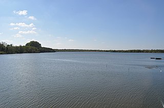
Hickling Broad is a 600-hectare (1,500-acre) nature reserve 4 km south-east of Stalham, north-east of Norwich in Norfolk. It is managed by the Norfolk Wildlife Trust. It is a National Nature Reserve and part of the Upper Thurne Broads and Marshes Site of Special Scientific Interest and Hickling Broad and Horsey Mere Nature Conservation Review site, Grade I. It is in the Norfolk Coast Area of Outstanding Natural Beauty, and part of the Broadland Ramsar site and Special Protection Area, and The Broads Special Area of Conservation.

Halvergate Marshes area of grazing marsh in the east of the English county of Norfolk

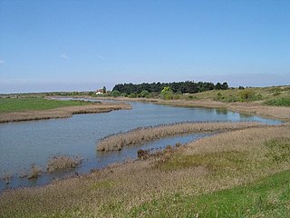
The Halvergate Marshes are an area of grazing marsh in the east of the English county of Norfolk. They form part of the area of The Broads and lie between the River Bure and the River Yare, bordering Breydon Water on the east. The marshes cover an area of around 2,642 hectares An area of 1,432.7-hectare (3,540-acre) is a biological Site of Special Scientific Interest. Some areas are also in the Breydon Water Local Nature Reserve, the Broadland and Breydon Water Ramsar sites, The Broads Special Area of Conservation, and The Broads and Breydon Water Special Protection Areas.

Calthorpe Broad lake in the United Kingdom

Calthorpe Broad is a 43.5-hectare (107-acre) biological Site of Special Scientific Interest east of Stalham in Norfolk. It is a Nature Conservation Review site, Grade I and a National Nature Reserve. It is also part of the Broadland Ramsar site and Special Protection Area, and The Broads Special Area of Conservation.

Martham Broad lake in the United Kingdom

Martham Broad is a 60-hectare (150-acre) National Nature Reserve north of Great Yarmouth in Norfolk. It is managed by the Norfolk Wildlife Trust, and is part of the Upper Thurne Broads and Marshes Site of Special Scientific Interest. It is also part of the Broadland Ramsar site and Special Protection Area, and The Broads Special Area of Conservation.

Dersingham Bog English nature reserve

Dersingham Bog is a 159.1-hectare (393-acre) biological and geological Site of Special Scientific Interest Norfolk. It is a Nature Conservation Review site, Grade 2, a National Nature Reserve and a Ramsar site It is part of the Norfolk Coast Area of Outstanding Natural Beauty, and the Roydon Common & Dersingham Bog Special Area of Conservation Part of it is a Geological Conservation Review site.

Barnby Broad and Marshes human settlement in United Kingdom

Barnby Broad and Marshes is a Site of Special Scientific Interest (SSSI) in the Waveney district of the English county of Suffolk. The site is 189.6 hectares in size. It is in the parishes of North Cove and Barnby, located between Beccles and Lowestoft in the north of the county. The site is bordered on its southern edge by the East Suffolk railway line and to the north by the River Waveney. It is a Special Area of Conservation, a Special Protection Area under the EC Birds Directive, and a Ramsar internationally important wetland site. There are two Suffolk Wildlife Trust nature reserves in the site, Castle Marshes and North Cove.

Holme Dunes

Holme Dunes is a 192-hectare (470-acre) nature reserve near Holme-next-the-Sea in Norfolk. It is managed by the Norfolk Wildlife Trust, and is a National Nature Reserve. It is part of the North Norfolk Coast Site of Special Scientific Interest, Geological Conservation Review site, Nature Conservation Review site, Grade I, Ramsar site, Special Areas of Conservation and Special Protection Area. It is also in the Norfolk Coast Area of Outstanding Natural Beauty.

Castle Marshes Suffolk Wildlife Trust nature reserve

Castle Marshes is a 71 hectare nature reserve west of Lowestoft in Suffolk. It is managed by the Suffolk Wildlife Trust. It is part of the Barnby Broad and Marshes Site of Special Scientific Interest the Broadland Ramsar internationally important wetland site, the Broadland Special Protection Area under the European Union Directive on the Conservation of Wild Birds, and The Broads Special Area of Conservation.

Ant Broads and Marshes

Ant Broads and Marshes is a 745.3-hectare (1,842-acre) biological Site of Special Scientific Interest north-east of Norwich in Norfolk. Most of the it is a Nature Conservation Review site, Grade 1, and it is part of the Broadland Ramsar and Special Protection Area, and The Broads Special Area of Conservation. Part of it is the Barton Broad nature reserve, which is managed by the Norfolk Wildlife Trust, and two areas are National Nature Reserves.

Bure Broads and Marshes

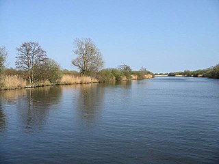
Bure Broads and Marshes is a 741.1-hectare (1,831-acre) biological Site of Special Scientific Interest north-east of Norwich in Norfolk. Most of it is a Nature Conservation Review site, Grade I and National Nature Reserve. Two areas are nature reserves managed by the Norfolk Wildlife Trust, Cockshoot Broad and Ranworth Broad. It is part of the Broadland Ramsar site and Special Protection Area and The Broads Special Area of Conservation,

Cantley Marshes

Cantley Marshes is a 272.1-hectare (672-acre) biological Site of Special Scientific Interest south-east of Norwich in Norfolk. It is managed by the Royal Society for the Protection of Birds, It is part of the Broadland Ramsar site and Special Protection Area, The Broads Special Area of Conservation and the Mid-Yare National Nature Reserve.

Ludham - Potter Heigham Marshes

Ludham - Potter Heigham Marshes is a 101.5-hectare (251-acre) biological Site of Special Scientific Interest north-east of Norwich in Norfolk. Part of the site is a Nature Conservation Review site, Grade I, and a National Nature Reserve. It is part of the Broadland Ramsar site and Special Protection Area, and The Broads Special Area of Conservation.

Upper Thurne Broads and Marshes

Upper Thurne Broads and Marshes is a 1,185.9-hectare (2,930-acre) biological Site of Special Scientific Interest north of Great Yarmouth in Norfolk. Part of it is a Nature Conservation Review site, Grade I, and it is in the Norfolk Coast Area of Outstanding Natural Beauty. It is part of the Broadland Ramsar site and Special Protection Area, and The Broads Special Area of Conservation. Two areas, Hickling Broad and Martham Broad, are National Nature Reserves managed by the Norfolk Wildlife Trust.

Upton Broad and Marshes

Upton Broad and Marshes is a 195.4-hectare (483-acre) biological Site of Special Scientific Interest east of Norwich in Norfolk. It is a Nature Conservation Review site, Grade I and a larger area of 318-hectare (790-acre) is managed by the Norfolk Wildlife Trust. It is part of the Broadland Ramsar site and Special Protection Area, and The Broads Special Area of Conservation.

Yare Broads and Marshes

Yare Broads and Marshes is a 744.5-hectare (1,840-acre) biological Site of Special Scientific Interest east of Norwich in Norfolk. Part of the site, is a Nature Conservation Review site, Grade I and most of it is in the Mid-Yare National Nature Reserve. It is part of the Broadland Ramsar site and Special Protection Area, and The Broads Special Area of Conservation. Two ares are Royal Society for the Protection of Birds nature reserves, Strumpshaw Fen and Surlingham Church Marsh.

Thursley, Hankley and Frensham Commons

Thursley, Hankley and Frensham Commons is a 1,878.5-hectare (4,642-acre) biological Site of Special Scientific Interest west of Godalming in Surrey. Thursley and Hankley Commons are Nature Conservation Review sites, Grade I. An area of 115.1 hectares is a Local Nature Reserve called The Flashes and an area of 180 hectares is the Elstead Group of Commons, a nature reserve managed by the Surrey Wildlife Trust. Thursley Common is a National Nature Reserve. An area of 265.7 hectares is the Thursley & Ockley Bogs Ramsar site. The site is a Special Protection Area and part of the Thursley, Ash, Pirbright & Chobham Special Area of Conservation.

References

  1. 1 2 3 4 "Designated Sites View: Roydon Common". Sites of Special Scientific Interest. Natural England. Retrieved 31 May 2018.
  2. "Map of Roydon Common". Sites of Special Scientific Interest. Natural England. Retrieved 31 May 2018.
  3. Ratcliffe, pp. 130–31, 212–13
  4. "Designated Sites View: Roydon Common". National Nature Reserves. Natural England. Retrieved 31 May 2018.
  5. "Designated Sites View: Roydon Common". Ramsar Site. Natural England. Retrieved 31 May 2018.
  6. "Designated Sites View: Roydon Common and Dersingham Bog". Special Area of Conservation. Natural England. Retrieved 31 May 2018.
  7. "Roydon Common and Grimston Warren". Norfolk Wildlife Trust. Retrieved 21 May 2018.
  8. "Roydon Common". Ramsar Sites Information Service. Retrieved 25 April 2018.
  9. "Roydon Common citation" (PDF). Sites of Special Scientific Interest. Natural England. Retrieved 31 May 2018.

Coordinates: 52°46′23″N0°30′04″E / 52.773°N 0.501°E / 52.773; 0.501

Geographic coordinate system Coordinate system

A geographic coordinate system is a coordinate system that enables every location on Earth to be specified by a set of numbers, letters or symbols. The coordinates are often chosen such that one of the numbers represents a vertical position and two or three of the numbers represent a horizontal position; alternatively, a geographic position may be expressed in a combined three-dimensional Cartesian vector. A common choice of coordinates is latitude, longitude and elevation. To specify a location on a plane requires a map projection.