
The Norfolk Wildlife Trust (NWT) is one of 46 wildlife trusts covering Great Britain, Northern Ireland, Isle of Man and Alderney. Founded in 1926, it is the oldest of all the trusts. It has over 35,500 members and eight local groups and it manages more than fifty nature reserves and other protected sites. It also gives conservation advice to individuals and organisations, provides educational services to young people on field trips and organises entertainment and information events at nature reserves. The NWT reserves include twenty-six Sites of Special Scientific Interests, nine national nature reserves, twelve Nature Conservation Review sites, sixteen Special Areas of Conservation, twelve Special Protection Areas, eleven Ramsar sites, two local nature reserves, four Geological Conservation Review sites and five which are in Areas of Outstanding Natural Beauty.
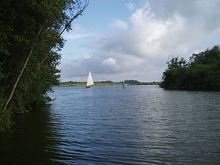
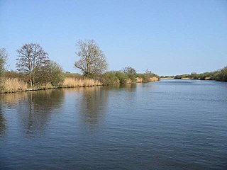
Barton Broad is a 164-hectare (410-acre) nature reserve north-east of Norwich in Norfolk. It is owned and managed by the Norfolk Wildlife Trust. It is part of the Ant Broads and Marshes Site of Special Scientific Interest and National Nature Reserve, and part of it is in the Ant Marshes Nature Conservation Review site, Grade I. It is part of the Broadland Ramsar site and Special Protection Area, and The Broads Special Area of Conservation.

Cockshoot Broad is a 5-hectare (12-acre) nature reserve north-east of Norwich in Norfolk. It is managed by the Norfolk Wildlife Trust. It is part of the Bure Broads and Marshes Site of Special Scientific Interest, and the Broadland Ramsar site and Special Protection Area, and The Broads Special Area of Conservation. It is also part of the Bure Marshes National Nature Reserve and Nature Conservation Review site, Grade I.

Suffolk Wildlife Trust (SWT) describes itself as the county's "nature charity – the only organisation dedicated wholly to safeguarding Suffolk's wildlife and countryside." It is a registered charity, and its headquarters is at Brooke House in Ashbocking, near Ipswich. It was founded in 1961, and is one of 46 wildlife trusts covering the Great Britain and Northern Ireland. As of March 2017, it has 13,200 members, and it manages 3,120 hectares of land in 60 nature reserves, most of which are open to the public. It had an income of £3.9 million in the year to 31 March 2017.

Great Eastern Pingo Trail is a 9.2 kilometres long footpath along a disused railway line north of Thetford in Norfolk. It is a 4.2-hectare (10-acre) Local Nature Reserve, and it crosses three Sites of Special Scientific Interest, Thompson Water, Carr and Common, Breckland Forest and Cranberry Rough, Hockham. It also crosses Thompson Common, which is a nature reserve managed by the Norfolk Wildlife Trust and is a Nature Conservation Review site, Grade I. It further crosses Norfolk Valley Fens Special Area of Conservation and Breckland Special Protection Area.

Thompson Water, Carr and Common is a 154.7-hectare (382-acre) biological Site of Special Scientific Interest north of Thetford in Norfolk. Most of it is managed by the Norfolk Wildlife Trust as Thompson Common. It is a Nature Conservation Review site, Grade I, and part of the Norfolk Valley Fens Special Area of Conservation. It is crossed by the Great Eastern Pingo Trail Local Nature Reserve.
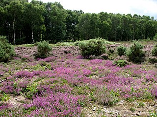
Buxton Heath is a 67.3-hectare (166-acre) biological Site of Special Scientific Interest north of Norwich in Norfolk. It is a Nature Conservation Review site, Grade 2, and part of the North Valley Fens Special Area of Conservation.

Blo' Norton and Thelnetham Fens are a 21.3-hectare (53-acre) biological Site of Special Scientific Interest (SSSI) on the Norfolk/Suffolk border. Blo' Norton Fen is in the parish of Blo' Norton in Norfolk and Thelnetham Fen is in Thelnetham parish in Suffolk. It is a Nature Conservation Review site, Grade 2, and part of the Waveney and Little Ouse Valley Fens Special Area of Conservation, Thelnetham Fen is managed by the Suffolk Wildlife Trust and Blo' Norton Fen by the Little Ouse Headwaters Project (LOHP).

Weeting Heath is a 141.8-hectare (350-acre) biological Site of Special Scientific Interest west of Thetford in Norfolk, which is managed by the Norfolk Wildlife Trust. It is a Nature Conservation Review site, Grade I, and a National Nature Reserve. It is also part of the Breckland Special Area of Conservation and Special Protection Area.
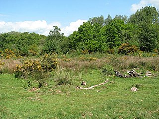
Hoe Rough is a 12-hectare (30-acre) nature reserve north of Dereham in Norfolk. It is managed by the Norfolk Wildlife Trust, and is part of the Beetley and Hoe Meadows Site of Special Scientific Interest.

Roydon Common is a 194.9-hectare (482-acre) biological Site of Special Scientific Interest east of King's Lynn in Norfolk. It is also a Grade I Nature Conservation Review site, a National Nature Reserve and a Ramsar site. It is part of the Roydon Common and Dersingham Bog Special Area of Conservation and Roydon Common and Grimston Warren nature reserve, which is managed by the Norfolk Wildlife Trust,
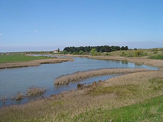
Holme Dunes is a 192-hectare (470-acre) nature reserve near Holme-next-the-Sea in Norfolk. It is managed by the Norfolk Wildlife Trust, and is a National Nature Reserve. It is part of the North Norfolk Coast Site of Special Scientific Interest, Geological Conservation Review site, Nature Conservation Review site, Grade I, Ramsar site, Special Areas of Conservation and Special Protection Area. It is also in the Norfolk Coast Area of Outstanding Natural Beauty.

Ant Broads and Marshes is a 745.3-hectare (1,842-acre) biological Site of Special Scientific Interest north-east of Norwich in Norfolk. Most of it is a Nature Conservation Review site, Grade 1, and it is part of the Broadland Ramsar and Special Protection Area, and The Broads Special Area of Conservation. Part of it is the Barton Broad nature reserve, which is managed by the Norfolk Wildlife Trust, and two areas are National Nature Reserves.
Bure Broads and Marshes is a 741.1-hectare (1,831-acre) biological Site of Special Scientific Interest north-east of Norwich in Norfolk. Most of it is a Nature Conservation Review site, Grade I and National Nature Reserve. Two areas are nature reserves managed by the Norfolk Wildlife Trust, Cockshoot Broad and Ranworth Broad. It is part of the Broadland Ramsar site and Special Protection Area and The Broads Special Area of Conservation,

Potter and Scarning Fens, East Dereham is a 6.2-hectare (15-acre) biological Site of Special Scientific Interest south of Dereham in Norfolk. It is part of the Norfolk Valley Fens Special Area of Conservation. Scarning Fen is a Nature Conservation Review site, Grade I, and it is managed by the Norfolk Wildlife Trust.

Upper Thurne Broads and Marshes is a 1,185.9-hectare (2,930-acre) biological Site of Special Scientific Interest north of Great Yarmouth in Norfolk. Part of it is a Nature Conservation Review site, Grade I, and it is in the Norfolk Coast Area of Outstanding Natural Beauty. It is part of the Broadland Ramsar site and Special Protection Area, and The Broads Special Area of Conservation. Two areas, Hickling Broad and Martham Broad, are national nature reserves managed by the Norfolk Wildlife Trust.

Swangey Fen, Attleborough is a 48.4-hectare (120-acre) biological Site of Special Scientific Interest south-west of Attleborough in Norfolk. It is part of the Norfolk Valley Fens Special Area of Conservation.

Badley Moor is an 18.3-hectare (45-acre) biological Site of Special Scientific Interest east of Dereham in Norfolk. It is part of the Norfolk Valley Fens Special Area of Conservation.

