Lolly Moor

Last updated
Lolly Moor
Lolly Moor 1.jpg
Type Nature reserve
Location Dereham, Norfolk
OS grid TF 992 103
Area 3 hectares (7.4 acres)
Managed by Norfolk Wildlife Trust

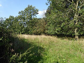
Lolly Moor is a 3-hectare (7.4-acre) nature reserve south of Dereham in Norfolk. It is managed by the Norfolk Wildlife Trust. [1]

Dereham town in Norfolk, England

Dereham, also known as East Dereham, is a town and civil parish in the English county of Norfolk. It is situated on the A47 road, about 15 miles (25 km) west of the city of Norwich and 25 miles (40 km) east of King's Lynn. The civil parish has an area of 21.51 km2 (8.31 sq mi) and in the 2001 census had a population of 15,659 in 6,941 households, the population at the 2011 Census increasing to 18,609. For the purposes of local government, Dereham falls within, and is the centre of administration for, the district of Breckland. The town should not be confused with the Norfolk village of West Dereham, which lies about 25 miles (40 km) away.

Norfolk County of England

Norfolk is a county in East Anglia in England. It borders Lincolnshire to the northwest, Cambridgeshire to the west and southwest, and Suffolk to the south. Its northern and eastern boundaries are the North Sea and, to the north-west, The Wash. The county town is Norwich. With an area of 2,074 square miles (5,370 km2) and a population of 859,400, Norfolk is a largely rural county with a population density of 401 per square mile. Of the county's population, 40% live in four major built up areas: Norwich (213,000), Great Yarmouth (63,000), King's Lynn (46,000) and Thetford (25,000).

Norfolk Wildlife Trust UK wildlife trust

The Norfolk Wildlife Trust (NWT) is one of forty-seven wildlife trusts covering Great Britain, Northern Ireland, Isle of Man and Alderney. Founded in 1926, it is the oldest of all the trusts. It has over 35,500 members and eight local groups and it manages more than fifty nature reserves and other protected sites. It also gives conservation advice to individuals and organisations, provides educational services to young people on field trips and organises entertainment and information events at nature reserves. The NWT reserves include twenty-six Sites of Special Scientific Interests, nine National Nature Reserves, twelve Nature Conservation Review sites, sixteen Special Areas of Conservation, twelve Special Protection Areas, eleven Ramsar sites, two Local Nature Reserves, four Geological Conservation Review sites and five which are in Areas of Outstanding Natural Beauty.

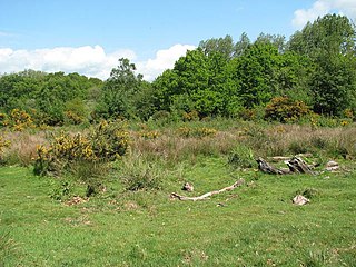
This site has wet grassland, scrub and alder carr. Flora include cowslip, lesser celandine, southern marsh orchid, marsh helleborine and twayblade. [1]

<i>Primula veris</i> species of plant

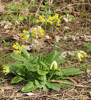
Primula veris is a herbaceous perennial flowering plant in the primrose family Primulaceae. The species is native throughout most of temperate Europe and western Asia, and although absent from more northerly areas including much of northwest Scotland, it reappears in northernmost Sutherland and Orkney and in Scandinavia. This species frequently hybridizes with other Primulas such as Primula vulgaris to form false oxlip which is often confused with true oxlip, a much rarer plant.

There is access from Dereham Road.

Related Research Articles

Ranworth Broad

Ranworth Broad is a 136-hectare (340-acre) nature reserve on the Norfolk Broads north-east of Norwich in Norfolk. It is managed by the Norfolk Wildlife Trust. it is part of Bure Broads and Marshes Site of Special Scientific Interest and Bure Marshes Nature Conservation Review site, Grade I. and National Nature Reverse It is also part of the Broadland Ramsar site and Special Protection Area, and The Broads Special Area of Conservation.

North Elmham railway station disused railway stationin Norfolk, UK

North Elmham railway station is a railway station in the village of North Elmham in the English county of Norfolk. The station was part of the Wymondham to Wells Branch, and is part of a section of the line being restored by the Mid-Norfolk Railway from Dereham to County School railway station.

Roydon Fen Suffolk Wildlife Trust nature reserve

Roydon Fen is a 17.2 hectare Local Nature Reserve south of Roydon, on the western outskirts of Diss in Norfolk. It is owned by South Norfolk District Council and managed by the Suffolk Wildlife Trust.

Hoe Rough human settlement in United Kingdom

Hoe Rough is a 12-hectare (30-acre) nature reserve north of Dereham in Norfolk. It is managed by the Norfolk Wildlife Trust, and is part of the Beetley and Hoe Meadows Site of Special Scientific Interest.

Salthouse Marshes human settlement in United Kingdom

Salthouse Marshes is a 66-hectare (160-acre) nature reserve west of Sheringham in Norfolk. It is managed by the Norfolk Wildlife Trust. It is part of the North Norfolk Coast Site of Special Scientific Interest, Geological Conservation Review site, Nature Conservation Review site, Grade I. Ramsar site, Special Areas of Conservation and Special Protection Area. It is also in the Norfolk Coast Area of Outstanding Natural Beauty.

Narborough Railway Line

Narborough Railway Line or Narborough Railway Embankment is a 7.9-hectare (20-acre) biological Site of Special Scientific Interest south-east of King's Lynn in Norfolk. It is a former railway embankment which is now a nature reserve managed by the Norfolk Wildlife Trust. It is 1 kilometre south of Narborough, on the A47 going east from King's Lynn to Swaffham, and it can be entered by a car park west of the reserve. It was documented in 1847 as an area with lots of chalk and flints.

Honeypot Wood

Honeypot Wood is a 9.5-hectare (23-acre) biological Site of Special Scientific Interest west of Dereham in Norfolk. It is managed by the Norfolk Wildlife Trust

Holme Dunes

Holme Dunes is a 192-hectare (470-acre) nature reserve near Holme-next-the-Sea in Norfolk. It is managed by the Norfolk Wildlife Trust, and is a National Nature Reserve. It is part of the North Norfolk Coast Site of Special Scientific Interest, Geological Conservation Review site, Nature Conservation Review site, Grade I, Ramsar site, Special Areas of Conservation and Special Protection Area. It is also in the Norfolk Coast Area of Outstanding Natural Beauty.

Ant Broads and Marshes

Ant Broads and Marshes is a 745.3-hectare (1,842-acre) biological Site of Special Scientific Interest north-east of Norwich in Norfolk. Most of the it is a Nature Conservation Review site, Grade 1, and it is part of the Broadland Ramsar and Special Protection Area, and The Broads Special Area of Conservation. Part of it is the Barton Broad nature reserve, which is managed by the Norfolk Wildlife Trust, and two areas are National Nature Reserves.

Beetley and Hoe Meadows

Beetley and Hoe Meadows is an 11.4-hectare (28-acre) biological Site of Special Scientific Interest north of Dereham in Norfolk. The site is in two nearby areas, and Hoe Meadow is part of Hoe Rough nature reserve, which is managed by the Norfolk Wildlife Trust

Bure Broads and Marshes

Bure Broads and Marshes is a 741.1-hectare (1,831-acre) biological Site of Special Scientific Interest north-east of Norwich in Norfolk. Most of it is a Nature Conservation Review site, Grade I and National Nature Reserve. Two areas are nature reserves managed by the Norfolk Wildlife Trust, Cockshoot Broad and Ranworth Broad. It is part of the Broadland Ramsar site and Special Protection Area and The Broads Special Area of Conservation,

Potter and Scarning Fens, East Dereham

Potter and Scarning Fens, East Dereham is a 6.2-hectare (15-acre) biological Site of Special Scientific Interest south of Dereham in Norfolk. It is part of the Norfolk Valley Fens Special Area of Conservation. Scarning Fen is a Nature Conservation Review site, Grade I, and it is managed by the Norfolk Wildlife Trust.

Upper Thurne Broads and Marshes

Upper Thurne Broads and Marshes is a 1,185.9-hectare (2,930-acre) biological Site of Special Scientific Interest north of Great Yarmouth in Norfolk. Part of it is a Nature Conservation Review site, Grade I, and it is in the Norfolk Coast Area of Outstanding Natural Beauty. It is part of the Broadland Ramsar site and Special Protection Area, and The Broads Special Area of Conservation. Two areas, Hickling Broad and Martham Broad, are National Nature Reserves managed by the Norfolk Wildlife Trust.

Upton Broad and Marshes

Upton Broad and Marshes is a 195.4-hectare (483-acre) biological Site of Special Scientific Interest east of Norwich in Norfolk. It is a Nature Conservation Review site, Grade I and a larger area of 318-hectare (790-acre) is managed by the Norfolk Wildlife Trust. It is part of the Broadland Ramsar site and Special Protection Area, and The Broads Special Area of Conservation.

Thorpe Marshes

Thorpe Marshes is a 25-hectare (62-acre) nature reserve east of Norwich in Norfolk. It is managed by the Norfolk Wildlife Trust.

Scarning Fen

Scarning Fen is a 4-hectare (9.9-acre) nature reserve west in Dereham in Norfolk. It is managed by the Norfolk Wildlife Trust. It is a Nature Conservation Review site, Grade I, and is part of Potter and Scarning Fens Site of Special Scientific Interest and Norfolk Valley Fens Special Area of Conservation.

Swangey Fen, Attleborough

Swangey Fen, Attleborough is a 48.4-hectare (120-acre) biological Site of Special Scientific Interest south-west of Attleborough in Norfolk. It is part of the Norfolk Valley Fens Special Area of Conservation.

Badley Moor

Badley Moor is an 18.3-hectare (45-acre) biological Site of Special Scientific Interest east of Dereham in Norfolk. It is part of the Norfolk Valley Fens Special Area of Conservation.

Mattishall Moor

Mattishall Moor is a 5.5-hectare (14-acre) biological Site of Special Scientific Interest east of Dereham in Norfolk.

References

  1. 1 2 "Lolly Moor". Norfolk Wildlife Trust. Retrieved 3 September 2018.

Coordinates: 52°39′14″N0°56′38″E / 52.654°N 0.944°E / 52.654; 0.944

Geographic coordinate system Coordinate system

A geographic coordinate system is a coordinate system that enables every location on Earth to be specified by a set of numbers, letters or symbols. The coordinates are often chosen such that one of the numbers represents a vertical position and two or three of the numbers represent a horizontal position; alternatively, a geographic position may be expressed in a combined three-dimensional Cartesian vector. A common choice of coordinates is latitude, longitude and elevation. To specify a location on a plane requires a map projection.