
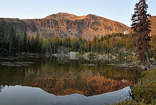
The North Cascades are a section of the Cascade Range of western North America. They span the border between the Canadian province of British Columbia and the U.S. state of Washington and are officially named in the U.S. and Canada as the Cascade Mountains. The portion in Canada is known to Americans as the Canadian Cascades, a designation that also includes the mountains above the east bank of the Fraser Canyon as far north as the town of Lytton, at the confluence of the Thompson and Fraser Rivers.

Little Jack is a 6,745-foot-elevation mountain summit in the North Cascades of Washington, United States. It is located within the Pasayten Wilderness. It is situated one mile south of its namesake Jack Mountain, west of Crater Mountain, and east of Ross Lake. Like many North Cascade peaks, Little Jack is more notable for its large, steep rise above local terrain than for its absolute elevation. In the early 1900s, the Forest Service built the Little Jack Trail for the purpose of grazing pack animals on the meadows of Little Jack Mountain. The name "Jack" refers to Jack Rowley, a gold prospector in the area during the late 1800s, who was credited with finding gold at Ruby Creek.

Mount Larrabee is a 7,865-foot (2,397-metre) Skagit Range mountain summit situated 1.4 mile south of the Canada–United States border, in the North Cascades of Washington state. It is located immediately southeast of American Border Peak within the Mount Baker Wilderness, which is part of the Mount Baker-Snoqualmie National Forest, and near North Cascades National Park. It is notable for its reddish coloring caused by oxidation of Iron in the rock. The rock consists of reddish interbedded and interfolded phyllites and greenstone. Originally known as Red Mountain, the name was changed in 1951 to honor Charles F. Larrabee (1895–1950), of the prominent Larrabee family of Bellingham, Washington. The toponym was officially adopted in 1951 by the U.S. Board on Geographic Names.

Goat Mountain is a 6,844-foot (2,086-metre) summit in the Skagit Range which is a subset of the North Cascades of Washington state. It is located south of Mount Larrabee and north of Mount Shuksan in the Mount Baker Wilderness, which is managed by the Mount Baker-Snoqualmie National Forest. Goat Mountain has a subsidiary 6,725 ft summit known as the west peak, and remnants of what was colloquially known as the Swamp Creek Glacier rest on the northern slope between the two summits. The nearest higher neighbor is Mount Chardonnay, 2.75 mi (4.43 km) to the east. The Silver Tip Mine was located on the south slope of the mountain near the 3,000 ft level. The mine produced silver and gold in the 1940s. Precipitation runoff from the mountain drains into tributaries of the Fraser River and the Nooksack River.

Napeequa Peak is an 8,073-foot (2,461-metre) pyramidal mountain summit located in the Glacier Peak Wilderness of the North Cascades in Washington state. The mountain is situated on the crest of the Cascade Range, on the shared border of Snohomish County and Chelan County, also straddling the boundary between the Mount Baker-Snoqualmie National Forest and the Wenatchee National Forest. Its nearest neighbor is Cirque Mountain, 0.3 mi (0.48 km) to the north, and the nearest higher peak is Buck Mountain, 2.56 mi (4.12 km) to the east-southeast. Precipitation runoff from the peak drains east to the headwaters of Napeequa River; or west into the Suiattle River. The mountain's name is taken from the river's name, which was applied by Albert Hale Sylvester (1871-1944), a pioneer surveyor, explorer, topographer, and forest supervisor in the Cascades.

Remmel Mountain, also known as Mount Remmel, is a prominent 8,685-foot (2,647-metre) mountain summit located in Okanogan County in Washington state. It is the highest point in the Cathedral Range, which is a subrange of the Okanogan Range in the North Cascades. The mountain is situated 5 miles (8.0 km) south of the Canada–United States border, on the eastern side of the Cascade crest, in the Pasayten Wilderness, on land managed by the Okanogan–Wenatchee National Forest. The nearest higher peak is Mount Lago, 16.8 miles (27.0 km) to the west-southwest, and Amphitheater Mountain lies 3.6 miles (5.8 km) to the north. Remmel is the third-highest summit of the Okanogan Range following Mount Lago (8,745 ft), and Robinson Mountain (8,726 ft). These three peaks follow Jack Mountain (9,075 ft) as the highest peaks in the Pasayten Wilderness. Remmel is the most prominent mountain in the Pasayten Wilderness. Topographic relief is significant as the summit rises approximately 2,300 feet above Andrews Creek in 0.75 mile (1.2 km). Precipitation runoff from Remmel Mountain drains into the Chewuch River basin.

Slate Peak is a 7,440-foot (2,270-metre) mountain summit located on the shared border between Okanogan County and Whatcom County in Washington state. It is part of the Okanogan Range, which is a sub-range of the North Cascades. The mountain is situated 15 miles (24 km) northwest of Mazama, on the boundary line of the Pasayten Wilderness, on land managed by the Okanogan–Wenatchee National Forest. The peak has the distinction of having the highest road in Washington, as well as the highest fire lookout. Although the narrow one-lane white-knuckle road reaches the summit of the mountain, the Forest Service gated it to vehicles, which necessitates walking the final few hundred yards. Additionally, the Pacific Crest Trail traverses the west slope of the peak, and the West Fork Pasayten Trail traverses the eastern slope. The nearest higher peak is Devils Peak, 2.57 miles (4.14 km) to the north. Precipitation runoff from Slate Peak drains east into Pasayten River, or west into Slate Creek, which is in the Skagit River drainage basin.
Sheep Mountain is an 8,274-foot (2,522-metre) mountain summit located in Okanogan County in Washington state. It is part of the Okanogan Range which is a sub-range of the North Cascades and Cascade Range. The mountain is situated less than 2 miles (3.2 km) south of the Canada–United States border, on the east side of the Cascade crest, in the Pasayten Wilderness, on land managed by the Okanogan–Wenatchee National Forest. The nearest higher peak is Andrew Peak, 8.3 miles (13.4 km) to the east-southeast. The Pacific Northwest Trail traverses the slopes of Sheep Mountain as it crosses Peeve Pass. Precipitation runoff from Sheep Mountain drains west into Peeve Creek, or east into tributaries of Ashnola River. The mountain was so named because for 40 years the meadows surrounding it were prime grazing land for sheep in the summer, before the protection of wilderness designation.

Apex Mountain is an 8,302-foot (2,530-metre) summit located in Okanogan County in Washington state. It is part of the Okanogan Range which is a sub-range of the North Cascades. The mountain is situated 2.5 miles (4.0 km) south of the Canada–United States border, on the east side of the Cascade crest, in the Pasayten Wilderness, on land managed by the Okanogan–Wenatchee National Forest. The nearest higher peak is Amphitheater Mountain, 2.35 miles (3.78 km) to the west-northwest. The Pacific Northwest Trail traverses the northern slopes of Apex Mountain as it crosses Apex Pass. Precipitation runoff from Apex Mountain drains west into Cathedral Creek, or east into Tungsten Creek, both tributaries of the Chewuch River. Topographic relief is significant as the summit rises 1,200 feet above Tungsten Lake in 0.3 mile (0.5 km).
Mount Lago is a prominent 8,745-foot (2,665-metre) mountain summit located in the Okanogan Range of the North Cascades, in Okanogan County of Washington state. The mountain is situated on the eastern side of the Cascade crest, in the Pasayten Wilderness, on land managed by the Okanogan–Wenatchee National Forest. The nearest higher peak is Jack Mountain, 19.5 miles (31.4 km) to the west-southwest. Mount Lago is the highest summit of the Okanogan Range, and follows only Jack Mountain {9,075 ft} as the highest peak in the Pasayten Wilderness. Lago is the fourth-most prominent mountain in the Pasayten Wilderness. Precipitation runoff from the mountain drains into tributaries of the Pasayten River and Methow River. The mountain was named for Lage Wernstedt (1878–1959), a Forest Service surveyor who made numerous first ascents of the mountains he was mapping in the North Cascades. Lago, is a play on the way Americans pronounced his name. Lage, pronounced Loggy, had a son named Lago.

Castle Peak is a prominent 8,343-foot (2,543-metre) mountain summit located in the Hozameen Range of the North Cascades, on the shared border between Okanogan County and Whatcom County of Washington state. The mountain is situated one mile (1.6 km) south of the Canada–United States border, on the Cascade crest, in the Pasayten Wilderness, on land managed by the Okanogan–Wenatchee National Forest. The nearest higher peak is Jack Mountain, 14.8 miles (23.8 km) to the south-southwest. Castle Peak is the second highest summit of the Hozameen Range following Jack Mountain. Castle Peak is the sixth-highest mountain in the Pasayten Wilderness. Precipitation runoff from the mountain drains east into Castle Creek, a tributary of the Similkameen River, or west into tributaries of the Skagit River. Topographic relief is significant as the summit rises nearly 3,000 feet above Crow Creek in 0.75 mile (1.2 km).
Mount Carru is an 8,595-foot (2,620-metre) mountain summit located in western Okanogan County in Washington state. It is the seventh-highest peak of the Okanogan Range, which is a sub-range of the North Cascades. The mountain is situated in the Pasayten Wilderness on land administered by the Okanogan–Wenatchee National Forest. The nearest higher peak is Mount Lago, 0.8 mile to the east, and Osceola Peak rises one mile (1.6 km) west. The mountain has a steep north face, but the south slope is covered in scree which allows a nontechnical climbing ascent. Precipitation runoff from Mount Carru drains north into Lease Creek which is a tributary of the Pasayten River, or south into Eureka Creek, which is part of the Methow River drainage basin.
Osceola Peak is an 8,587-foot (2,617-metre) mountain summit located in western Okanogan County in Washington state. The mountain's name was officially adopted in 1972. Osceola is the 10th highest peak of the Okanogan Range, which is a sub-range of the North Cascades. Osceola Peak ranks 50th on Washington's highest 100 peaks, and 48th on the "Bulger List". The mountain is situated in the Pasayten Wilderness, on land managed by the Okanogan–Wenatchee National Forest. The nearest higher peak is Mount Carru, 1 mile (1.6 km) to the east. The mountain has a steep north face, but the south slope is covered in scree which allows a nontechnical climbing ascent. Precipitation runoff from Osceola Peak drains north into tributaries of the Similkameen River, or south into Eureka Creek, which is part of the Methow River drainage basin.

Brahma Peak is a remote 8,079-foot (2,462-metre) mountain summit located on Chiwawa Ridge in the North Cascades, in Chelan County of Washington state. The mountain is situated in the Glacier Peak Wilderness, on land managed by the Wenatchee National Forest. The nearest higher neighbor is Buck Mountain, 1.8 mi (2.9 km) to the north. Brahma and Buck are set on Chiwawa Ridge, and other notable peaks on this ridge include Fortress Mountain, Cirque Mountain, Napeequa Peak, Mount Berge, Bandit Peak, and Chiwawa Mountain. Precipitation runoff from Brahma and meltwater from its glacier remnants drains into Chiwawa River and Napeequa River, both tributaries of the Wenatchee River. Topographic relief is significant since the southwest lavender-colored schist cliffs of this peak rise nearly 4,000 feet above the Napeequa River Valley in approximately one mile.

Cirque Mountain is a 7,966-foot (2,428-metre) mountain summit located in the Glacier Peak Wilderness of the North Cascades in Washington state. The mountain is situated on the crest of the Cascade Range, on the shared border of Snohomish County and Chelan County, also straddling the boundary between the Mount Baker-Snoqualmie National Forest and the Wenatchee National Forest. Its nearest higher peak is Napeequa Peak, 0.3 mi (0.48 km) to the south. The peak is set on Chiwawa Ridge with Napeequa, and other notable peaks on this ridge include Fortress Mountain, Buck Mountain, Brahma Peak, Mount Berge, and Chiwawa Mountain. Topographic relief is significant since the western aspect of the mountain rises 4,000 feet above the Suiattle Valley in approximately 1.5 mi (2.4 km). This mountain has small, unnamed, hanging glaciers in cirques surrounding the summit. Precipitation runoff from the peak and meltwater from the glaciers drains east to the headwaters of Napeequa River; or west into the Suiattle River.

Pasayten Peak is a 7,850-foot (2,390-metre) pyramidal-shaped mountain summit located in western Okanogan County in Washington state. It is part of the Okanogan Range which is a sub-range of the North Cascades. The mountain is situated in the Pasayten Wilderness, on land administered by the Okanogan–Wenatchee National Forest. The nearest higher neighbor is Wildcat Mountain, 3 miles (4.8 km) to the east-southeast, and Slate Peak is set 3.7 miles (6.0 km) to the south. Pasayten Peak is the high point of Gold Ridge, and precipitation runoff from this peak drains into the West and Middle Forks of Pasayten River.

Skagit Peak is a 6,824-foot (2,080-metre) mountain summit located in the North Cascades, in Whatcom County of Washington state. It is situated on the western side of the Cascade crest, at the western edge of the Pasayten Wilderness, on land managed by the Okanogan–Wenatchee National Forest. Skagit Peak is part of the Hozameen Range, a subset of the North Cascades which also includes Hozomeen Mountain to the north, and Jack Mountain to the south. Precipitation runoff from this mountain drains into the Skagit River via Three Fools Creek and Ross Lake.

Spratt Mountain is a 7,258-foot (2,212-metre) mountain summit located in the North Cascades, in Whatcom County of Washington state. It is situated on the western side of the Cascade crest, at the western edge of the Pasayten Wilderness, on land managed by the Okanogan–Wenatchee National Forest. Spratt Mountain is part of the Hozameen Range, a subset of the North Cascades which also includes Skagit Peak four miles to the north, and Jack Mountain six miles to the south. Precipitation runoff from this mountain drains into Ross Lake via Three Fools Creek and Dry Creek.

Jackita Ridge is a 7,350-foot (2,240-metre) ridge located in the Pasayten Wilderness, in Whatcom County of Washington state. It is part of the Hozameen Range which is a subset of the North Cascades. The highest point is called Jackita Peak, and the Jackita Ridge Trail traverses below the west aspect of this summit, providing access for an off-trail scramble to the top. The nearest higher neighbor is Crater Mountain, 3.9 miles (6.3 km) to the southwest, Jack Mountain is set 4.77 miles (7.68 km) to the west, and McKay Ridge is 5.7 miles (9.2 km) to the south. Precipitation runoff from this ridge drains to Ross Lake via Devils Creek and Canyon Creek, which are part of the Skagit River drainage basin. The first ascent may have been made in 1926 by the United States Coast and Geodetic Survey, which placed a Jackita benchmark.

Mount Winthrop is a prominent 7,850-foot (2,393-metre) mountain summit located in Okanogan County of Washington state. The mountain is part of the Hozameen Range of the North Cascades and is situated 2 miles (3.2 km) south of the Canada–United States border within the Pasayten Wilderness, on land managed by the Okanogan–Wenatchee National Forest. The nearest higher peak is Frosty Mountain, 4.6 miles (7.4 km) to the northwest. Precipitation runoff from the mountain drains into tributaries of the Similkameen River. Like many North Cascades peaks, Mount Winthrop is more notable for its steep rise above local terrain than for its absolute elevation. Topographic relief is significant as the west aspect rises 2,850 feet (870 m) above Route Creek in 1.0 mile (1.6 km). The Pacific Northwest Trail traverses the southeast slope of the mountain and the Pacific Crest Trail traverses the western base of the mountain.


