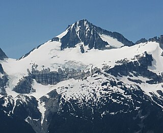
Primus Peak is located in North Cascades National Park in the U.S. state of Washington. Primus Peak is flanked by North Klawatti Glacier to the south and Borealis Glacier to the northeast. Tricouni Peak is situated immediately east of Primus Peak.

Cosho Peak is in North Cascades National Park in the U.S. state of Washington. Cosho Peak is a summit along a ridge known as Ragged Ridge and the Kimtah Glacier is on the northeast slopes of the peak.
Kimtah Peak, elevation 8,600+ feet, is in North Cascades National Park in the U.S. state of Washington. Kimtah Peak is a summit along a ridge known as Ragged Ridge. Kimtah Glacier is on the northwest slopes of the peak, while Katsuk Glacier is to the northeast.
Mount Fury, elevation 8,280+ ft, is in North Cascades National Park in the U.S. state of Washington. Several small glaciers are on the slopes of Mount Fury, and it is the second tallest peak in the Picket Range, after Luna Peak which lies 2.6 mi (4.2 km) to the northeast.

Neve Peak is in North Cascades National Park in the U.S. state of Washington. Located in the south unit of the park, Neve Peak is .66 mi (1.06 km) west of Colonial Peak. The Neve Glacier is just south of Neve Peak while the Colonial Glacier descends from the north slopes of the mountain.

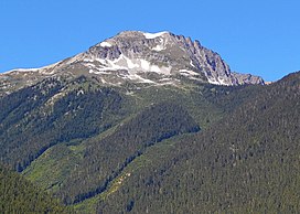
Big Kangaroo is an 8,326-foot (2,538-metre) mountain summit in Okanogan County, Washington, United States.

Graybeard Peak is a 7,965-foot (2,428-metre) mountain summit located in Skagit County, Washington.

The Needles is an 8,160-foot (2,487-metre) granite mountain located in Okanogan County in Washington state. It is part of the Okanogan Range which is a sub-range of the North Cascades Range. The Needles is situated on land administered by the Okanogan–Wenatchee National Forest. Precipitation runoff from the peak drains into tributaries of the Methow River. Topographic relief is significant as the summit rises 3,660 feet above Pine Creek in approximately 1.25 mile (2 km). The nearest higher neighbor is Tower Mountain, 2.26 miles (3.64 km) to the southwest.

Gilbert Mountain is an 8,023-foot (2,445-metre) massif located in Okanogan County in Washington state. It is part of the Methow Mountains which are a subrange of the North Cascades. The mountain is situated within the Lake Chelan-Sawtooth Wilderness which is managed by Okanogan–Wenatchee National Forest. The northwestern extreme of the Gilbert massif connects to the southern end of Kangaroo Ridge. Precipitation runoff from the mountain drains into the Twisp River. Topographic relief is significant as it rises over 4,000 feet above the river in approximately one mile.

Icy Peak is a 7,073-foot (2,156-metre) Skagit Range mountain summit located in the North Cascades of Washington state. It is situated in North Cascades National Park at the head of Nooksack Cirque. High ridges connect it to Seahpo Peak and Mount Shuksan. An icefall occupies the northeast cirque, and small glaciers clad all sides of the peak. Precipitation runoff drains into the Nooksack and Baker Rivers.

Repulse Peak is a 7,923-foot (2,415-metre) mountain summit in the North Cascades in the U.S. state of Washington. It is located on the border of the Stephen Mather Wilderness and North Cascades National Park. It is situated midway between Black Peak and Fisher Peak, and can be seen from the North Cascades Highway. Precipitation runoff from Repulse Peak drains into tributaries of the Skagit River and Stehekin River. Topographic relief is significant as the east face rises over 2,900 feet in 0.53 mile (0.85 km).

Helen Buttes are two prominent summits near the western edge of the North Cascades, in Skagit County of Washington state. The buttes are located four miles northwest of Marblemount, Washington, in the Noisy-Diobsud Wilderness, on land administered by the Mount Baker-Snoqualmie National Forest. The nearest higher neighbor is Diobsud Buttes, 3.11 miles (5.01 km) to the north. Precipitation runoff from Helen Buttes drains into tributaries of the Skagit River.

Holliway Mountain is an 8000+ ft granite summit located in Okanogan County in Washington state. It is part of the Okanogan Range which is a sub-range of the North Cascades Range. Holliway Mountain is situated near the headwaters of the Methow River on land administered by the Okanogan–Wenatchee National Forest. The nearest higher peak is Golden Horn, 0.91 miles (1.46 km) to the south. Azurite Peak is located three miles to the north-northwest.

Mount Misch is a remote 7,435 ft mountain summit in the North Cascades, in Skagit County of Washington state. It is the highest point of the Buckindy Range, or Buckindy Ridge. It is located 19 miles east-northeast of Darrington, Washington, and 15 miles north-northwest of Glacier Peak which is one of the Cascade stratovolcanoes. It is situated in the Glacier Peak Wilderness on land administered by the Mount Baker-Snoqualmie National Forest. Mount Misch was named by mountaineer and author Fred Beckey for his friend Peter Misch (1909-1987), University of Washington geology professor and mountaineer, who was renowned for his study of the North Cascades. Precipitation runoff from Mount Misch and the unnamed Goat Creek glacier on its east slope drains into tributaries of the Suiattle River and ultimately the Skagit River.

Inspiration Peak is a 7,891-foot (2,405-metre) mountain summit located in the Picket Range within North Cascades National Park in the state of Washington. The peak lies 0.28 mi (0.45 km) east of Mount Degenhardt, and 0.47 mi (0.76 km) west of McMillan Spires. Terror Glacier remnants lie to the south of the peaks, and the McMillan Cirque glaciers hang on the north slopes. The first ascent of Inspiration Peak was made in 1940 by Fred Beckey and his brother Helmy via the West Ridge. Inspiration Peak can be seen from the North Cascades National Park Newhalem visitor center, weather permitting.
Tricouni Peak is an 8,102-foot (2,469-metre) mountain summit located in Skagit County of Washington state. It is situated in North Cascades National Park, north of the North Klawatti Glacier and southeast of the Borealis Glacier. The nearest higher peak is Primus Peak, 0.54 mi (0.87 km) to the west. Precipitation runoff from Tricouni drains into Thunder Creek. The peak is named for the tricouni which was used for traction on ice, and the approach to the peak involves traversing a glacier.

Tiffany Mountain is an 8,245-foot (2,513-metre) mountain summit located in Okanogan County in Washington state. It is the highest point in the Tiffany Range, which is a sub-range of the Okanogan Range. The mountain is situated on the east side of the Cascade crest, on land managed by the Okanogan–Wenatchee National Forest. The nearest higher peak is Windy Peak, 18 miles (29 km) to the north. Precipitation runoff from Tiffany Mountain drains into tributaries of the Columbia River.

Pasayten Peak is a 7,850-foot (2,390-metre) pyramidal-shaped mountain summit located in western Okanogan County in Washington state. It is part of the Okanogan Range which is a sub-range of the North Cascades. The mountain is situated in the Pasayten Wilderness, on land administered by the Okanogan–Wenatchee National Forest. The nearest higher neighbor is Wildcat Mountain, 3 miles (4.8 km) to the east-southeast, and Slate Peak is set 3.7 miles (6.0 km) to the south. Pasayten Peak is the high point of Gold Ridge, and precipitation runoff from this peak drains into the West and Middle Forks of Pasayten River.
Elija Ridge is a prominent 7,739 ft (2,360 m) ridge located in North Cascades National Park, in Whatcom County of Washington state. It is part of the North Cascades which is a subset of the Cascade Range. The highest point is called Elija Peak, and another peak on this ridge with sufficient prominence to qualify as a separate summit is called Ezekiel,. The nearest higher neighbor is Gabriel Peak, 1.9 miles (3.1 km) to the southeast, Beebe Mountain is set 1.86 miles (2.99 km) to the northeast, and Ruby Mountain is 4.86 miles (7.82 km) to the northwest. Precipitation runoff from this ridge drains to Ross Lake via Panther Creek. This geographical feature is named after the prophet Elija, which is a reference to Tommy Rowland who settled in the Skagit River area in 1895 and later pronounced himself the "Prophet Elisha." Gabriel Peak, Genesis Peak, and Mount Prophet are also named in association with Rowland.

Gabriel Peak is a prominent 7,920-foot (2,410 m)-elevation mountain summit located in North Cascades National Park, in Skagit County of Washington state. It is part of the North Cascades which is a subset of the Cascade Range. The nearest higher neighbor is Cosho Peak, 2.7 miles (4.3 km) to the south, Beebe Mountain is set 2.5 miles (4.0 km) to the north, and Red Mountain is 3 miles (4.8 km) to the southwest. Precipitation runoff from this feature drains to Ross Lake via Gabriel and Panther Creeks. Like many North Cascade peaks, Gabriel Peak is more notable for its large, steep rise above local terrain than for its absolute elevation. Topographic relief is significant as it rises 4,700 feet (1,400 m) above the Panther Creek valley in approximately one mile. This geographical feature is named after the archangel Gabriel, which is a reference to Tommy Rowland who settled in the Skagit River area in 1895 and later pronounced himself the "Prophet Elisha." Mount Prophet, Genesis Peak, and nearby Elija Ridge were also named in association with Rowland.