Cumberland, Oklahoma

Last updated

Cumberland, Oklahoma
USA Oklahoma location map.svg
Red pog.svg
Cumberland
Usa edcp location map.svg
Red pog.svg
Cumberland
Coordinates: 34°03′53″N96°35′59″W / 34.06472°N 96.59972°W / 34.06472; -96.59972
Country United States
State Oklahoma
County Marshall
Area
[1]
  Total
1.37 sq mi (3.5 km2)
  Land1.27 sq mi (3.3 km2)
  Water0.09 sq mi (0.2 km2)
Elevation
[2]
722 ft (220 m)
Population
 (2020) [3]
  Total
315
  Density247.3/sq mi (95.5/km2)
Time zone UTC-6 (Central (CST))
  Summer (DST) UTC-5 (CDT)
ZIP Code
73446 (Madill)
Area code 580
FIPS code 40-18750 [1]
GNIS feature ID1091884 [2]

Cumberland is an unincorporated community and census-designated place [4] in Marshall County, Oklahoma, United States. The population was 315 as of the 2020 Census. [3]

Contents

History

A post office was established at Cumberland, Indian Territory, on March 31, 1894. It was named for Cumberland Presbyterian Church, an organization active in local mission work. [5]

At the time of its founding, Cumberland was located in Pickens County, Chickasaw Nation. [6]

Geography

Cumberland is in eastern Marshall County, about 12 miles (19 km) east of Madill, the county seat. It is 1.5 miles (2.4 km) south of Oklahoma State Highway 199 and is west of the Washita River arm of Lake Texoma. [7]

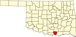
According to the U.S. Census Bureau, the Cumberland CDP has a total area of 1.37 square miles (3.55 km2), of which 1.27 square miles (3.29 km2) are land and 0.09 square miles (0.23 km2) are water. [1] Texoma Shores Resort (formerly known as Cumberland Cove) is the community's main tourism driver, where fishing and swimming are the primary activities of interest.

References

  1. 1 2 3 "2024 U.S. Gazetteer Files: Oklahoma". United States Census Bureau. Retrieved May 7, 2025.
  2. 1 2 U.S. Geological Survey Geographic Names Information System: Cumberland
  3. 1 2 "P1. Race – Cumberland CDP, Oklahoma: 2020 DEC Redistricting Data (PL 94-171)". U.S. Census Bureau. Retrieved May 7, 2025.
  4. U.S. Geological Survey Geographic Names Information System: Cumberland Census Designated Place
  5. George H. Shirk. Oklahoma Place Names (Norman: University of Oklahoma Press, 1965), p. 58.
  6. Charles Goins, Historical Atlas of Oklahoma (Norman: University of Oklahoma Press, 2006), plate 105.
  7. "Madill, Oklahoma to Cumberland, Oklahoma". Google Maps. Retrieved July 18, 2024.