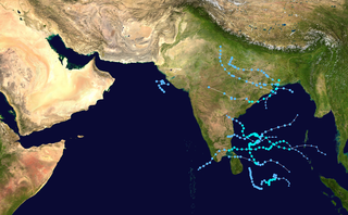
The 2005 North Indian Ocean cyclone season caused much devastation and many deaths in Southern India despite the storms’ weakness. The basin covers the Indian Ocean north of the equator as well as inland areas, sub-divided by the Arabian Sea and the Bay of Bengal. Although the season began early with two systems in January, the bulk of activity was confined from September to December. The official India Meteorological Department tracked 12 depressions in the basin, and the unofficial Joint Typhoon Warning Center (JTWC) monitored two additional storms. Three systems intensified into a cyclonic storm, which have sustained winds of at least 63 km/h (39 mph), at which point the IMD named them.

The 1992 North Indian Ocean cyclone season was unofficially the most active year on record for the basin, with 10 tropical storms developing, according to the Joint Typhoon Warning Center (JTWC). There are two main seas in the North Indian Ocean – the Bay of Bengal to the east of the Indian subcontinent – and the Arabian Sea to the west of India. The official Regional Specialized Meteorological Centre in this basin is the India Meteorological Department (IMD), while the JTWC releases unofficial advisories. An average of four to six storms form in the North Indian Ocean every season with peaks in May and November. Cyclones occurring between the meridians 45°E and 100°E are included in the season by the IMD.

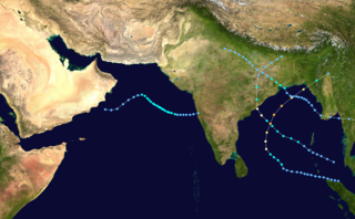
The 2002 North Indian Ocean cyclone season was a below average season in terms of tropical cyclone formation. The season had no official bounds, but most storms formed in either May or after October. No depressions or storms formed during the monsoon season from July to September, the first such instance on record. There are two main seas in the North Indian Ocean – the Bay of Bengal to the east of the Indian subcontinent – and the Arabian Sea to the west of India. The official Regional Specialized Meteorological Centre in this basin is the India Meteorological Department (IMD), while the Joint Typhoon Warning Center (JTWC) releases unofficial advisories. An average of four to six storms form in the North Indian Ocean every season with peaks in May and November. Cyclones occurring between the meridians 45°E and 100°E are included in the season by the IMD.

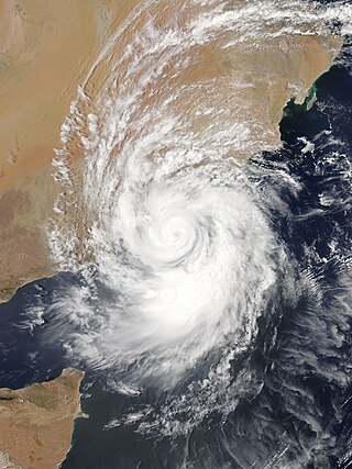
The 2002 Oman cyclone was a tropical cyclone that struck the Dhofar region of Oman in May 2002. The first storm of the 2002 North Indian Ocean cyclone season, it developed on May 6 in the Arabian Sea, and it maintained a general west-northwest track for much of its duration. The system reached cyclonic storm status on May 9, meaning it attained winds of greater than 65 km/h (40 mph), and on May 10 it made landfall near Salalah; shortly thereafter it dissipated. The storm was rare, in the sense that it was one of only twelve tropical cyclones on record to approach the Arabian Peninsula in the month of May.
The 1995 North Indian Ocean cyclone season was below-average and was primarily confined to the autumn months, with the exception of three short-lived deep depressions in May. There were eight depressions in the basin, which is Indian Ocean north of the equator. The basin is subdivided between the Bay of Bengal and the Arabian Sea on the east and west coasts of India, respectively. Storms were tracked by the India Meteorological Department (IMD), which is the basin's Regional Specialized Meteorological Center, as well as the American-based Joint Typhoon Warning Center (JTWC) on an unofficial basis.

The 1996 North Indian Ocean cyclone season featured several deadly tropical cyclones, with over 2,000 people killed during the year. The India Meteorological Department (IMD) – the Regional Specialized Meteorological Center for the northern Indian Ocean as recognized by the World Meteorological Organization – issued warnings for nine tropical cyclones in the region. Storms were also tracked on an unofficial basis by the American-based Joint Typhoon Warning Center, which observed one additional storm. The basin is split between the Bay of Bengal off the east coast of India and the Arabian Sea off the west coast. During the year, the activity was affected by the monsoon season, with most storms forming in June or after October.

The 1998 North Indian Ocean cyclone season was an active season in annual cycle of tropical cyclone formation. The season has no official bounds but cyclones tend to form between April and December. These dates conventionally delimit the period of each year when most tropical cyclones form in the northern Indian Ocean. There are two main seas in the North Indian Ocean—the Bay of Bengal to the east of the Indian subcontinent and the Arabian Sea to the west of India. The official Regional Specialized Meteorological Centre in this basin is the India Meteorological Department (IMD), while the Joint Typhoon Warning Center releases unofficial advisories. An average of four to six storms form in the North Indian Ocean every season with peaks in May and November. Cyclones occurring between the meridians 45°E and 100°E are included in the season by the IMD.

The 1989 North Indian Ocean cyclone season was a below-average season in annual cycle of tropical cyclone formation. Despite this, the season had the second highest Accumulated Cyclone Energy in the basin on record behind only 2019 and 2023. The season has no official bounds but cyclones tend to form between April and December. These dates conventionally delimit the period of each year when most tropical cyclones form in the northern Indian Ocean. There are two main seas in the North Indian Ocean—the Bay of Bengal to the east of the Indian subcontinent and the Arabian Sea to the west of India. The official Regional Specialized Meteorological Centre in this basin is the India Meteorological Department (IMD), while the Joint Typhoon Warning Center (JTWC) releases unofficial advisories. An average of five tropical cyclones form in the North Indian Ocean every season with peaks in May and November. Cyclones occurring between the meridians 45°E and 100°E are included in the season by the IMD.

The 2011 North Indian Ocean cyclone season was the least active tropical cyclone season in the North Indian Ocean since 1993. Only two cyclonic storms formed, below the average of four to six. The North Indian Ocean cyclone season has no official bounds, but cyclones tend to form between April and December, with peaks in May and November. These dates conventionally delimit the period of each year when most tropical cyclones form in the northern Indian Ocean. The scope of this article is limited to the Indian Ocean in the Northern Hemisphere, east of the Horn of Africa and west of the Malay Peninsula. There are two main seas in the North Indian Ocean — the Arabian Sea to the west of the Indian subcontinent, abbreviated ARB by the India Meteorological Department (IMD); and the Bay of Bengal to the east, abbreviated BOB by the IMD.

Very Severe Cyclonic Storm Phet was a powerful tropical cyclone that made landfall on Oman, Western India, and Pakistan. The third named cyclone of the 2010 cyclone season, Phet developed in the Arabian Sea on May 31 to the west of India. With conducive environmental conditions, the storm intensified to reach peak sustained winds of 155 km/h (95 mph) on June 2, based on analysis by the India Meteorological Department (IMD). On the next day, Phet dropped heavy rainfall while moving across eastern Oman, with a peak of 603 mm (23.7 in) in Qurayyat. The rains flooded arid areas and collected into wadis – normally dry river beds. Thousands of homes were wrecked across Oman. There were 24 fatalities in the country, and damage was estimated at US$780 million.

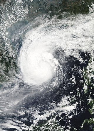
Typhoon Amy, known in the Philippines as Typhoon Gening, was the second typhoon to strike China in a week during mid-July 1991. An area of convection was first observed on July 13 within the vicinity of Yap. A tropical depression developed the next day. While initially tracking westward, the system slowly deepened, becoming Tropical Storm Amy on July 16. After briefly turning northwestward, Amy intensified into a typhoon on July 17. Continuing to intensify as it tracked through the Luzon Strait, Amy reached its peak intensity of 175 km/h (110 mph) on July 18. That evening, the typhoon began to show signs of weakening, although it was still believed to have been a typhoon when it made landfall in the province of Guangdong on July 19, becoming the strongest tropical cyclone to hit the province in 22 years. Once inland, the storm rapidly weakened, and by late on July 20, had dissipated completely.
Typhoon Nepartak, known in the Philippines as Typhoon Weng, was a modest tropical cyclone that struck the central Philippines and the southern China island of Hainan in November 2003. Forming as a tropical depression on November 11 between Yap and Guam, the system moved westward and slowly intensified. It received the name Nepartak midday on November 12 from the Japan Meteorological Agency, becoming the 20th named storm of the 2003 Pacific typhoon season. On November 13, Napartak struck Samar in the Philippines and bisected the island chain. Up to four million people lost power, and transportation ground to a halt; over 5,000 individuals became stranded on ships forced to stay in port during the tropical storm. It was reported that 13 individuals died in the storm in the Philippines.

Extremely Severe Cyclonic Storm Nilofar was, at the time, the third-strongest cyclone in the Arabian Sea. In late October 2014, it reached peak maximum sustained winds estimated between 205 km/h (125 mph) and 215 km/h (130 mph). The India Meteorological Department (IMD) named it Nilofar; the name refers to the water lily, and was suggested by Pakistan. The western fringes of the storm caused flash flooding in northeastern Oman, killing four people.

The October 1996 India cyclone had an unusual and protracted path that spanned much of the northern Indian Ocean. It originated in a weather disturbance that formed on October 14 in the southern Bay of Bengal, off India's east coast. Moving westward, it struck Andhra Pradesh on October 17 as a well-defined low-pressure area. It crossed southern India and reorganized in the Arabian Sea off the western coast of India. The system developed into a depression on October 22 and quickly intensified while moving northward. By October 24, the cyclone approached hurricane intensity as it developed an eye, reaching peak winds of at least 110 km/h (70 mph). On October 25, the storm abruptly stalled and weakened off Gujarat, and progressed southwestward as a minimal storm. It was no longer classifiable as a tropical cyclone by October 28, although its remnants persisted until November 2 when they dissipated east of Somalia.
Typhoon Betty, known in the Philippines as Typhoon Aring, was the strongest typhoon to strike the Philippines in ten years. An area of disturbed weather developed on October 27, 1980, near Truk Atoll. After turning east from south, the disturbance was classified as a tropical storm on October 29 as it passed near Guam, causing only minor damage. Following a turn to the west-northwest, Betty attained typhoon intensity the next day. On November 4, Betty peaked in intensity. Later that day, Betty moved ashore over Luzon, introducing a rapid weakening trend. Over land, Betty then began to turn north due to a weakening subtropical ridge to its north and a trough offshore Taiwan. By November 8, Betty, after moving offshore, had completed its transition into an extratropical cyclone, and dissipated that same day.

The 2020 North Indian Ocean cyclone season was the costliest North Indian Ocean cyclone season on record, mostly due to the devastating Cyclone Amphan. The North Indian Ocean cyclone season has no official bounds, but cyclones tend to form between April and November, with peaks in late April to May and October to November. These dates conventionally delimit the period of each year when most tropical cyclones form in the northern Indian Ocean. The season began on May 16 with the designation of Depression BOB 01 in the Bay of Bengal, which later became Amphan. Cyclone Amphan was the strongest storm in the Bay of Bengal in 21 years and would break Nargis of 2008's record as the costliest storm in the North Indian Ocean. The season concluded with the dissipation of Cyclone Burevi on December 5. Overall, the season was slightly above average, seeing the development of five cyclonic storms.
Extremely Severe Cyclonic Storm Mekunu was the strongest storm to strike Oman's Dhofar Governorate since 1959. The second named storm of the 2018 North Indian Ocean cyclone season, Mekunu developed out of a low-pressure area on May 21. It gradually intensified, passing east of Socotra on May 23 as a very intense tropical cyclone. On May 25, Mekunu reached its peak intensity. The India Meteorological Department estimated 10 minute sustained winds of 175 km/h (110 mph), making Mekunu an extremely severe cyclonic storm. The American-based Joint Typhoon Warning Center estimated slightly higher 1 minute winds of 185 km/h (115 mph). While at peak intensity, Mekunu made landfall near Raysut, Oman, on May 25. The storm rapidly weakened over land, dissipating on May 27.

Very Severe Cyclonic Storm Luban was the third tropical cyclone to affect the Arabian Peninsula during the 2018 North Indian Ocean cyclone season, after cyclones Sagar and Mekunu in May. Luban developed on October 6 in the central Arabian Sea, and for much of its duration, maintained a general west-northwestward trajectory. On October 10, the India Meteorological Department (IMD) upgraded Luban to a very severe cyclonic storm – equivalent to a Category 1 hurricane – and estimated maximum sustained winds of 140 km/h (85 mph). The storm made landfall on October 14 in eastern Yemen, as a cyclonic storm. The storm quickly weakened over the dry, mountainous terrain of the Arabian Peninsula, before dissipating on October 15.

Very Severe Cyclonic Storm Hikaa was a tropical cyclone that struck eastern Oman in September 2019. The third named storm of the 2019 North Indian Ocean cyclone season, Hikaa formed on September 22 west of India in the Arabian Sea. The storm reached peak intensity on September 24, with maximum sustained winds estimated over 140 km/h (85 mph). Later that day, the storm made landfall in eastern Oman south of Duqm, and quickly dissipated over the Arabian Peninsula. The name Hikaa was named by Maldives, which refers to the 'scorpion' in Maldivian.


