The 2005 North Indian Ocean cyclone season caused much devastation and many deaths in Southern India despite the storms’ weakness. The basin covers the Indian Ocean north of the equator as well as inland areas, sub-divided by the Arabian Sea and the Bay of Bengal. Although the season began early with two systems in January, the bulk of activity was confined from September to December. The official India Meteorological Department tracked 12 depressions in the basin, and the unofficial Joint Typhoon Warning Center (JTWC) monitored two additional storms. Three systems intensified into a cyclonic storm, which have sustained winds of at least 63 km/h (39 mph), at which point the IMD named them.

The 2006 North Indian Ocean cyclone season had no bounds, but cyclones tend to form between April and December, with peaks in May and November. These dates conventionally delimit the period of each year when most tropical cyclones form in the northern Indian Ocean.

The 2007 North Indian Ocean cyclone season was one of the most active North Indian Ocean cyclone seasons on record. The North Indian Ocean cyclone season has no official bounds, but cyclones tend to form between April and December, with peaks in May and November. These dates conventionally delimit the period of each year when most tropical cyclones form in the northern Indian Ocean.
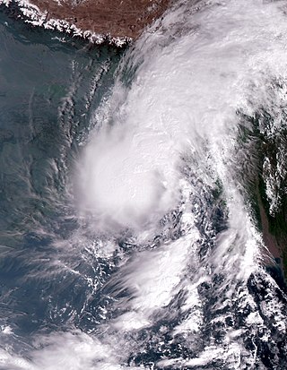
Cyclonic Storm Akash was the first named tropical cyclone of the 2007 North Indian Ocean cyclone season. Warned by both India Meteorological Department (IMD) and Joint Typhoon Warning Center (JTWC), it formed from an area of disturbed weather on the Bay of Bengal on May 12, and gradually organized as it drifted northward. An eye began to develop as it approached land, and after reaching peak 3-min sustained winds of 85 km/h (55 mph) it struck about 115 km (71 mi) south of Chittagong in Bangladesh. Akash rapidly weakened over land, and advisories were discontinued on May 15.

The 2004 North Indian Ocean cyclone season was the first in which tropical cyclones were officially named in the basin. Cyclone Onil, which struck India and Pakistan, was named in late September. The final storm, Cyclone Agni, was also named, and crossed into the southern hemisphere shortly before dissipation. This storm became notable during its origins and became one of the storms closest to the equator. The season was fairly active, with ten depressions forming from May to November. The India Meteorological Department designated four of these as cyclonic storms, which have maximum sustained winds of at least 65 km/h (40 mph) averaged over three minutes. The Joint Typhoon Warning Center also issued warnings for five of the storms on an unofficial basis.

The 2002 North Indian Ocean cyclone season was a below average season in terms of tropical cyclone formation. The season had no official bounds, but most storms formed in either May or after October. No depressions or storms formed during the monsoon season from July to September, the first such instance on record. There are two main seas in the North Indian Ocean – the Bay of Bengal to the east of the Indian subcontinent – and the Arabian Sea to the west of India. The official Regional Specialized Meteorological Centre in this basin is the India Meteorological Department (IMD), while the Joint Typhoon Warning Center (JTWC) releases unofficial advisories. An average of four to six storms form in the North Indian Ocean every season with peaks in May and November. Cyclones occurring between the meridians 45°E and 100°E are included in the season by the IMD.

The 2000 North Indian Ocean cyclone season was fairly quiet compared to the year before, 1999 North Indian Ocean cyclone season, with all of the activity originating in the Bay of Bengal. The basin comprises the Indian Ocean north of the equator, with warnings issued by the India Meteorological Department (IMD) in New Delhi. There were six depressions throughout the year, of which five intensified into cyclonic storms – tropical cyclones with winds of 65 mph (105 km/h) sustained over 3 minutes. Two of the storms strengthened into a Very Severe Cyclonic Storm, which has winds of at least 120 km/h (75 mph), equivalent to a minimal hurricane. The Joint Typhoon Warning Center (JTWC) also tracked storms in the basin on an unofficial basis, estimating winds sustained over 1 minute.

The 1994 North Indian Ocean cyclone season was a below-average year in which eight tropical cyclones affected seven countries bordering the North Indian Ocean. The India Meteorological Department tracks all tropical cyclones in the basin, north of the equator. The first system developed on March 21 in the Bay of Bengal, the first March storm in the basin since 1938. The second storm was the most powerful cyclone of the season, attaining maximum sustained winds of 215 km/h (135 mph) in the northern Bay of Bengal. Making landfall near the border of Bangladesh and Myanmar, the cyclone killed 350 people and left US$125 million in damage.

The 2009 North Indian Ocean cyclone season was an event in the annual cycle of tropical cyclone formation. The North Indian Ocean cyclone season has no official bounds, but cyclones tend to form between April and December, with peaks in May and November. These dates conventionally delimit the period of each year when most tropical cyclones form in the northern Indian Ocean.

Cyclonic Storm Bijli, was the first tropical cyclone to form during the 2009 North Indian Ocean cyclone season. Bijli formed from an area of Low Pressure on April 14. Later that evening, RSMC New Delhi upgraded the low-pressure area to a Depression and designated it as BOB 01. The Joint Typhoon Warning Center (JTWC) then issued a Tropical Cyclone Formation Alert for the system and soon after designated it as Tropical Depression 01B. On the evening of April 15, both RSMC New Delhi and the JTWC reported that the system had intensified into a tropical storm, with the former naming it Bilji. Soon after, Bilji reached its peak intensity as it approached the coast of Bangladesh. However, on the morning of April 17, Bijli weakened to a deep depression due to land interaction, before making landfall just south of Chittagong. The remnants of Bilji continued to weaken as they tracked across northern Myanmar, before RSMC New Delhi issued their last advisory on April 18. The word Bijli refers to lightning in Hindi.

At least 29 tropical cyclones have affected Myanmar, a country adjacent to the Bay of Bengal in mainland Southeast Asia. Myanmar has witnessed some of the deadliest storms in the Bay of Bengal, including Cyclone Nargis in May 2008, which struck the low-lying Irrawaddy Delta near Yangon. Its winds and storm surge killed an estimated 140,000 people and left nearly $10 billion in damage. The country's worst natural disaster in the 20th century was a cyclone in 1968, which killed more than 1,000 people when it hit Rakhine State in northwestern Myanmar. One of the most powerful storms to ever hit the country was Cyclone Mocha, which it moved ashore northwestern Myanmar in May 2023, killing at least 413 people.

India is a country in the north of Indian Ocean that is the most vulnerable to getting hit by tropical cyclones in the basin, from the east or from the west. On average, 2–3 tropical cyclones make landfall in India each year, with about one being a severe tropical cyclone or greater.

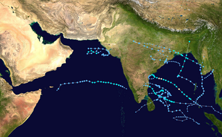
The 2013 North Indian Ocean cyclone season was an event in the annual cycle of tropical cyclone formation, in which tropical cyclones formed in the North Indian Ocean and Arabian Sea. The season had no official bounds, but cyclones typically formed between May and December, with the peak from October to November. These dates conventionally delimit the period of each year when most tropical cyclones form in the northern Indian Ocean.

The 2015 North Indian Ocean cyclone season was an event in the annual cycle of tropical cyclone formation. The North Indian Ocean cyclone season has no official bounds, but cyclones tend to form between months of April and December, with the peak from May to November. These dates conventionally delimit the period of each year when most tropical cyclones form in the northern Indian Ocean.

The 2016 North Indian Ocean cyclone season was an event in the annual cycle of tropical cyclone formation. It was the deadliest season since 2010, killing more than 400 people. The season was an average one, seeing four named storms, with one further intensifying into a very severe cyclonic storm. The first named storm, Roanu, developed on 19 May while the season's last named storm, Vardah, dissipated on 18 December. The North Indian Ocean cyclone season has no official bounds, but cyclones tend to form between April and December, with the two peaks in May and November. These dates conventionally delimit the period of each year when most tropical cyclones form in the northern Indian Ocean.

The 2017 North Indian Ocean cyclone season was a below average yet deadly season in the annual cycle of tropical cyclone formation. This season produced only three named storms, of which one only intensified into a very severe cyclonic storm. The North Indian Ocean cyclone season has no official bounds but cyclones tend to form between April and December with the two peaks in May and November. These dates conventionally delimit the period of each year when most tropical cyclones form in the northern Indian Ocean. The season began with the formation Cyclone Maarutha on April 15 and ended with the dissipation of a deep depression on December 9.

The 2018 North Indian Ocean cyclone season was one of the most active North Indian Ocean cyclone seasons since 1992, with the formation of fourteen depressions and seven cyclones. The North Indian Ocean cyclone season has no official bounds, but cyclones tend to form between April and December, with the two peaks in May and November. These dates conventionally delimit the period of each year when most tropical cyclones form in the northern Indian Ocean.
The 2022 North Indian Ocean cyclone season was an event in the annual cycle of tropical cyclone formation. It was an above-average season in terms of depressions and average in terms of deep depressions, but slightly below average in terms of cyclonic storms. It was also the least deadly North Indian Ocean cyclone season since 1988, according to official data. The season's strongest tropical cyclone was Cyclone Asani, with maximum wind speeds of 100 km/h and a minimum barometric pressure of 982 hPa. The North Indian Ocean cyclone season has no official bounds, but cyclones tend to form between April and December, with the peak from May to November. These dates conventionally delimit the period of each year when most tropical cyclones form in the northern Indian Ocean.
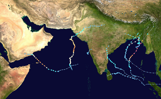
The 2023 North Indian Ocean cyclone season was an above-average and deadly season, becoming the deadliest season since 2017, mainly due to Cyclone Mocha. With nine depressions and six cyclonic storms forming, it became the most active season, featuring the second-highest accumulated cyclone energy (ACE) on record only behind 2019. It also had the most extremely severe cyclonic storms on record, tieing with 1999 and 2019. The North Indian Ocean cyclone season has no official bounds, but cyclones tend to form between April and December, with the peak from May to November. These dates conventionally delimit the period of each year when most tropical cyclones form in the northern Indian Ocean. However, a cyclone can form at any time during the year shown by an unnamed depression that affected Sri Lanka in January-February.
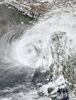
Cyclonic Storm Sitrang was a weak tropical cyclone that affected India and Bangladesh in late October 2022. It was the first cyclone to make landfall in Bangladesh since Cyclone Mora in 2017. Formed on 22 October offshore Andaman and Nicobar Islands, it gradually intensified and peaked as a high-end cyclonic storm before making landfall over Bangladesh close to Barisal by the early hours of 25 October.