Cyclone Mala

Last updated

Map key
  Tropical depression (≤38 mph, ≤62 km/h)
  Tropical storm (39–73 mph, 63–118 km/h)
  Category 1 (74–95 mph, 119–153 km/h)
  Category 2 (96–110 mph, 154–177 km/h)
  Category 3 (111–129 mph, 178–208 km/h)
  Category 4 (130–156 mph, 209–251 km/h)
  Category 5 (≥157 mph, ≥252 km/h)
  Unknown
Storm type
Disc Plain black.svg Tropical cyclone
Solid black.svg Subtropical cyclone
ArrowUp.svg Extratropical cyclone, remnant low, tropical disturbance, or monsoon depression

In mid to late April 2006, a pulse in the Madden–Julian oscillation, coupled with a Kelvin wave (which later contributed to the formation of Typhoon Chanchu in the western Pacific), enhanced convective activity over the Bay of Bengal. [2] By April 22, a trough developed along an axis from the southern Bay of Bengal eastward to the Andaman Sea. [1] The Joint Typhoon Warning Center (JTWC) began monitoring the system for potential tropical cyclogenesis the following day. [3] By 0600  UTC on April 24, an area of low pressure formed southeast of the Andaman Islands and the India Meteorological Department (IMD) began monitoring the disturbance. [4] Quickly organizing, the low developed into a tropical depression later on April 24 and the JTWC began writing full advisories on the cyclone without issuing a Tropical Cyclone Formation Alert. [3] [5] Organization slowed thereafter due to moderate wind shear, [6] but continued at a near-climatological rate as upper-level outflow allowed for continued convective development. [7] Early on April 25, the JTWC estimated the system to have attained gale-force winds. [5] The IMD followed suit later that day and subsequently assigned it the name Mala. [8] [nb 1] Weak steering currents prompted slow and erratic movement with an overall northward trajectory. [3] [6]

Cyclone Mala on April 26 struggling to develop under strong wind shear Cyclone Mala 26 apr 2006 0435Z.jpg
Cyclone Mala on April 26 struggling to develop under strong wind shear

Forecasters at this time anticipated little intensification as the system was expected to move into a region of higher shear. [10] However, on April 27, the system moved under a subtropical ridge and conditions quickly became favorable for intensification. The presence of the ridge greatly enhanced the outflow over the cyclone and an eye developed by 1200 UTC. [1] [11] By this time, both the JTWC and IMD estimated Mala to have attained hurricane-force winds with the latter classifying it as a very severe cyclonic storm. [1] [5] The previously weak steering currents became more established as well, with the storm now tracking northeast toward Myanmar through a weakness in a ridge over Southeast Asia. [11] Situated in an area with sea surface temperatures of 28 to 29 °C (82 to 84 °F), the cyclone was able to undergo rapid intensification as wind shear abruptly diminished. [1] The IMD estimated Mala to have reached its peak intensity at 0900 UTC on April 28 with winds of 185 km/h (115 mph) and a barometric pressure of 954 mbar (hPa; 28.17  inHg). [12] Using the Dvorak technique, a method of determining a tropical cyclone's strength via satellite imagery, the agency gave Mala a rating of T#5.5 which yields an intensity of 189 km/h (117 mph). [1]

The JTWC estimated Mala to have been a stronger system, with peak winds of 220 km/h (135 mph) and a pressure of 922 mb (hPa; 27.23 inHg) — equivalent to a Category 4 hurricane on the Saffir–Simpson hurricane wind scale. [5] Their Dvorak values peaked at T#6.5 or 235 km/h (145 mph). [13] As the powerful storm approached Myanmar, the combined effects of increasing wind shear and land interaction soon took their toll on Mala. [14] At 0700 UTC on April 29, Mala made landfall just south of Thandwe in Myanmar's Rakhine State as a very severe cyclonic storm. [1] The JTWC estimated winds at this time to have been 165 km/h (105 mph). [5] Rapid weakening ensued once the cyclone moved onshore. Within 12 hours of landfall, Mala weakened to a deep depression and was last noted as a dissipating system earl on April 30. [1]

Sea surface temperatures in the wake of Cyclone Mala decreased up to 4–5 °C (7–9 °F) due to upwelling. [15] From April 28–29, the low-level inflow associated affected much of the northern Bay of Bengal and resulted in northwesterly winds as far away as Hyderabad, India. These winds brought dry, dust filled air over the bay with mean particulate-matter doubling over the region. [16]

Preparations

On April 26, the local Department of Meteorology and Hydrology in Myanmar stated that the Ayeyarwady, Bago Region, and Yangon regions were likely to be affected within two days and Rakhine State within three days. [17] Officials began broadcasting storm warning to the public over radio the following day. [18] Evacuations of at-risk coastal areas were conducted, though specifics are unknown. [19] Once the storm moved inland, residents across the country were advised of the likelihood of widespread heavy rain from the remnant system. [20]

Despite never being forecast to strike Bangladesh, officials there warned residents that the storm could strike the nation and cause loss of life. Cautionary signals were raised at ports in Chittagong, Cox's Bazar, and Mongla, advising seafaring vessels to remain docked until the storm's passage. [21] Roughly 34,000 members of the Bangladesh Red Crescent Society were placed on standby for possible relief efforts. [9]

Flash flood warnings were issued across northern Thailand on April 29 under the threat of heavy rains from Mala's remnants. [18]

Impact

Cyclone Mala making landfall in Rakhine State on April 29 Cyclone Mala on April 29, 2006 at 0633 UTC.jpg
Cyclone Mala making landfall in Rakhine State on April 29

Throughout almost the entire existence of Mala, it produced rainfall in the Andaman and Nicobar islands. Daily totals peaked on April 27 at 100 mm (3.9 in) in Car Nicobar. [1]

After moving through Myanmar, Mala brought heavy rains to northern Thailand. According to local meteorologists the storm also accelerated the onset of the seasonal monsoon which would contribute to a wetter-than-average year for the region. [22]

Myanmar

Though Mala struck Myanmar as a powerful cyclone, early warnings and proper evacuations minimized loss of life along coastal areas. Additionally, no major storm surge was reported, limiting the potential for major damage. The most significant effects were caused inland from torrential rains rather than at the coast. [19] Overall, the storm claimed 37 lives and left 1.24 billion kyat (US$6.7 million) in damage. [23] [24] [25] Approximately 12,000 families were significantly affected by the cyclone. [26]

Rakhine State suffered a direct hit from the cyclone, with Gwa Township reporting the worst damage. There, 88 homes were destroyed and 1,246 more were damaged. One person was killed and at least four others were injured in the township. Ra Haing Ku Toe village suffered significant losses as well, with 132 homes destroyed and 531 more damaged. [27] A storm surge of 4.57 m (15.0 ft) struck the region, but did not impact populated areas. [24]

Across the Irrawaddy Delta, hurricane-force winds caused extensive damage to housing and infrastructure. [27] Haigyi Island was the first area struck by the storm. Several homes were destroyed and many more lost their roof there. [28] Thunderstorms from the storm's outer bands on April 28 damaged 586 homes in Hlaingthaya Township. Residents described what appeared to be a tornado as the cause of the damage. The Hlaingthaya industrial zone was hardest hit, with five factories destroyed and dozens of homes having their roof torn off. [29] Locals, however, claimed that the damage was more severe than reported by the government. [30] Cars were reportedly tossed into the air during the storm. [29] Two people were killed and fourteen others were injured in Hlaingthaya. [27] The winds also downed numerous power lines, leaving many without electricity. [30] In Labutta Township, near the southern tip of the Delta, 88 homes were destroyed. [27] In the Hinthada District, torrential rains caused flash flooding that killed 18 people and left 14 others missing. [19]

Aftermath

By May 1, the local branch of the Red Cross distributed essential supplies to residents in Labutta Township. In coordination with the Disaster Assistance Response Team, the areas in greatest need for aid were identified and requests for tarpaulin were made. [27] Members of the Cabinet of Burma donated 3.7 million kyat (US$2,960) in cash and 140 bags of rice to victims in the Ayeyarwady Region. [31] On May 3, another 1.7 million kyat (US$1,360) was donated by social organizations to residents in rural areas outside Yangon. [32] Temporary shelters were set up across Gwa Township. Local donations provided residents in the town with 200,000 kyat (US$160) worth of blankets, clothes, and cash. [27] A local newspaper, The New Light of Myanmar, claimed that government officials immediately provided assistance to affected residents across the country. [33] Red Cross operations continued through November 30, by which time 3,485 families were provided with aid. [26] Additionally, though the agency planned to assist 4,000 families with rebuilding their homes, a lack of necessary funds prevented the operation. Instead, a cash donation was provided to the 1,000 most affected families. [34]

See also

Notes

  1. The name Mala is Sinhalese as well as Hindi for a garland of flowers. [9]

Related Research Articles

<span class="mw-page-title-main">2006 Pacific typhoon season</span> Typhoon season in the Western Pacific Ocean

The 2006 Pacific typhoon season was a near-average season which produced a total of 23 named storms, 15 typhoons, and six super typhoons. The season ran throughout 2006, though most tropical cyclones typically develop between May and October. The season's first named storm, Chanchu, developed on May 9, while the season's last named storm, Trami, dissipated on December 20.

<span class="mw-page-title-main">1992 North Indian Ocean cyclone season</span>

The 1992 North Indian Ocean cyclone season was unofficially the most active year on record for the basin, with 10 tropical storms developing, according to the Joint Typhoon Warning Center (JTWC). There are two main seas in the North Indian Ocean – the Bay of Bengal to the east of the Indian subcontinent – and the Arabian Sea to the west of India. The official Regional Specialized Meteorological Centre in this basin is the India Meteorological Department (IMD), while the JTWC releases unofficial advisories. An average of four to six storms form in the North Indian Ocean every season with peaks in May and November. Cyclones occurring between the meridians 45°E and 100°E are included in the season by the IMD.

<span class="mw-page-title-main">2006 North Indian Ocean cyclone season</span> North Indian Ocean tropical cyclone season

The 2006 North Indian Ocean cyclone season had no bounds, but cyclones tend to form between April and December, with peaks in May and November. These dates conventionally delimit the period of each year when most tropical cyclones form in the northern Indian Ocean.

<span class="mw-page-title-main">Typhoon Dot (1985)</span> Pacific typhoon in 1985

Typhoon Dot, known in the Philippines as Typhoon Saling, was the strongest storm of the 1985 season. Dot originated from a small area of thunderstorm activity in early to mid October. The system was first classified on October 11, and steadily intensified over the next few days. Dot attained typhoon strength on October 15, and subsequently entered a period of explosive deepening, which was not anticipated by forecasters. The next day the intensification rate slowed, but that evening, Dot attained its maximum intensify. A steady weakening trend began on October 17, though the system maintained typhoon intensity through the passage of the Philippines. After entering the South China Sea late on October 18, Dot briefly re-intensified, only to weaken as it approached Vietnam. On October 21, Dot struck Vietnam while still a typhoon, but dissipated the next day over the high terrain of the nation.

<span class="mw-page-title-main">Typhoon Kent (1995)</span> Pacific typhoon in 1995

Super Typhoon Kent, known in the Philippines as Typhoon Gening, was a powerful Category 4-equivalent typhoon that formed in late August during the 1995 Pacific typhoon season.

<span class="mw-page-title-main">Cyclone Daman</span> Category 4 South Pacific cyclone in 2007

Severe Tropical Cyclone Daman was the strongest cyclone of the 2007–08 South Pacific cyclone season. Cyclone Daman was the fourth tropical depression and the first severe tropical cyclone to form east of longitude 180° during the 2007–08 South Pacific cyclone season. Due to the severity of the storm, the name Daman was retired and replaced with Denia.

<span class="mw-page-title-main">2002 North Indian Ocean cyclone season</span> Cyclone season in the North Indian Ocean

The 2002 North Indian Ocean cyclone season was a below average season in terms of tropical cyclone formation. The season had no official bounds, but most storms formed in either May or after October. No depressions or storms formed during the monsoon season from July to September, the first such instance on record. There are two main seas in the North Indian Ocean – the Bay of Bengal to the east of the Indian subcontinent – and the Arabian Sea to the west of India. The official Regional Specialized Meteorological Centre in this basin is the India Meteorological Department (IMD), while the Joint Typhoon Warning Center (JTWC) releases unofficial advisories. An average of four to six storms form in the North Indian Ocean every season with peaks in May and November. Cyclones occurring between the meridians 45°E and 100°E are included in the season by the IMD.

<span class="mw-page-title-main">1998 North Indian Ocean cyclone season</span> Cyclone season in the North Indian ocean

The 1998 North Indian Ocean cyclone season was an active season in annual cycle of tropical cyclone formation. The season has no official bounds but cyclones tend to form between April and December. These dates conventionally delimit the period of each year when most tropical cyclones form in the northern Indian Ocean. There are two main seas in the North Indian Ocean—the Bay of Bengal to the east of the Indian subcontinent and the Arabian Sea to the west of India. The official Regional Specialized Meteorological Centre in this basin is the India Meteorological Department (IMD), while the Joint Typhoon Warning Center releases unofficial advisories. An average of four to six storms form in the North Indian Ocean every season with peaks in May and November. Cyclones occurring between the meridians 45°E and 100°E are included in the season by the IMD.

<span class="mw-page-title-main">Cyclone Monica</span> Category 5 Australian region cyclone in 2006

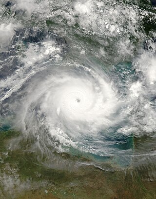
Severe Tropical Cyclone Monica was the most intense tropical cyclone, in terms of maximum sustained winds, on record to impact Australia. The 17th and final storm of the 2005–06 Australian region cyclone season, Monica originated from an area of low pressure off the coast of Papua New Guinea on 16 April 2006. The storm quickly developed into a Category 1 cyclone the next day, at which time it was given the name Monica. Travelling towards the west, the storm intensified into a severe tropical cyclone before making landfall in Far North Queensland, near Lockhart River, on 19 April 2006. After moving over land, convection associated with the storm quickly became disorganised.

<span class="mw-page-title-main">Cyclone Arthur (2007)</span> Category 2 South Pacific cyclone in 2007

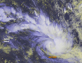
Cyclone Arthur was the eighth tropical depression and fourth tropical cyclone of the 2006–07 South Pacific cyclone season. Forming as tropical depression on January 25, Arthur rapidly intensified into a strong Category 2 cyclone on the Australian intensity scale according to the Regional Specialized Meteorological Centre in Nadi, Fiji. The Joint Typhoon Warning Center assessed the storm to have peaked as a minimal category 1 cyclone. Shortly after peaking in intensity, the cyclone began to weaken due to unfavorable conditions. Quickly moving towards the east-southeast, the Arthur began to undergo an extratropical transition. After turning towards the southeast, the center of circulation was almost fully exposed due to strong wind shear. However, Arthur briefly re-strengthened late on January 26 before becoming extratropical the next day. Tropical Cyclone Arthur affected several small islands during its existence. French Polynesia observed the most noteworthy effects from the storm, where several landslides damaged a few homes.

<span class="mw-page-title-main">Typhoon Angela (1989)</span> Pacific typhoon in 1989

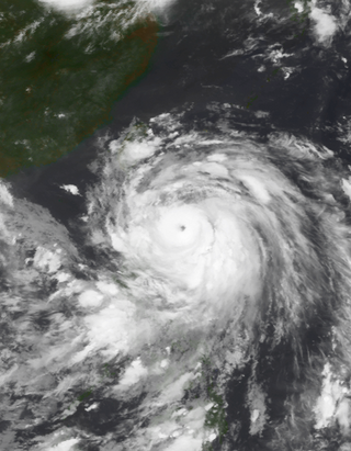
Typhoon Angela, known in the Philippines as Typhoon Rubing, was an intense tropical cyclone that formed in late September 1989. The storm developed from a tropical disturbance in the monsoon trough and moved generally westward throughout its duration. The storm ultimately peaked in intensity as a super typhoon and struck northern Luzon in the Philippines. After weakening and traversing the South China Sea, Angela bypassed Hainan to the south and struck Vietnam before dissipating. The storm caused severe damage and 119 fatalities in the Philippines. Thousands of houses were damaged, and hundreds of thousands of residents were impacted by the typhoon. Monetary damage is placed at $8 million.

<span class="mw-page-title-main">Cyclone Clare</span> Category 3 Australian region cyclone in 2006

Severe Tropical Cyclone Clare was a moderately strong cyclone that struck Western Australia in January 2006. The storm formed as an area of low pressure in the Arafura Sea, and moved westward. After receiving the name Clare on 7 January, the system ultimately peaked at Category 3 intensity on the Australian tropical cyclone scale. It moved ashore on the coast of the Pilbara and proceeded inland, dissipating on 10 January. Clare produced winds of 142 km/h (88 mph) at Karratha and triggered widespread torrential rainfall that led to flooding. Following its usage, the name Clare was retired by the Bureau of Meteorology, and will never be used again for a tropical cyclone in the area.

<span class="mw-page-title-main">Tropical cyclones in Myanmar</span>

At least 29 tropical cyclones have affected Myanmar, a country adjacent to the Bay of Bengal in mainland Southeast Asia. Myanmar has witnessed some of the deadliest storms in the Bay of Bengal, including Cyclone Nargis in May 2008, which struck the low-lying Irrawaddy Delta near Yangon. Its winds and storm surge killed an estimated 140,000 people and left nearly $10 billion in damage. The country's worst natural disaster in the 20th century was a cyclone in 1968, which killed more than 1,000 people when it hit Rakhine State in northwestern Myanmar. One of the most powerful storms to ever hit the country was Cyclone Mocha, which it moved ashore northwestern Myanmar in May 2023, killing at least 413 people.

<span class="mw-page-title-main">2013 North Indian Ocean cyclone season</span> North Indian Ocean tropical cyclone season

The 2013 North Indian Ocean cyclone season was an event in the annual cycle of tropical cyclone formation, in which tropical cyclones formed in the North Indian Ocean and Arabian Sea. The season had no official bounds, but cyclones typically formed between May and December, with the peak from October to November. These dates conventionally delimit the period of each year when most tropical cyclones form in the northern Indian Ocean.

<span class="mw-page-title-main">Cyclone Hudah</span> South-West Indian and Australian cyclone in 2000

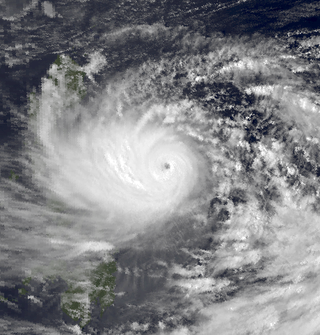
Very Intense Tropical Cyclone Hudah was a powerful and destructive tropical cyclone that affected Southeast Africa in April 2000. It was the last in a series of three cyclones that impacted Madagascar during the year. Hudah first developed as a disturbance embedded within the monsoon trough on 22 March, within the Australian region cyclone basin. Moving westward as the result of a strong subtropical ridge to its south, the storm quickly intensified, and reached Category 2 cyclone intensity on 25 March before entering the Southwest Indian cyclone basin. For various reasons that remain unknown, the cyclone was only designated a name by the time it had crossed into the area of responsibility of the Regional Specialized Meteorological Center in Réunion. Nonetheless, Météo-France (MFR) assigned the name Hudah to the cyclone. An eye formed, and the storm intensified into a tropical cyclone on 27 March well to the southeast of Diego Garcia. On 1 April, the MFR upgraded it to a very intense tropical cyclone, estimating peak 10-minute winds of 225 km/h (140 mph). By contrast, the Joint Typhoon Warning Center (JTWC) estimated 1-minute winds of 235 km/h (146 mph). At this time, the MFR estimated the pressure to have been 905 hPa (mbar), making Hudah the most intense tropical cyclone worldwide in 2000. Cyclone Hudah maintained peak winds until making landfall just southeast of Antalaha, Madagascar on 2 April. It weakened greatly over land, but re-attained tropical cyclone status on 5 April after moving over the Mozambique Channel. Hudah reached 10-minute winds of 160 km/h (99 mph) by the time it made landfall on Mozambique near Pebane, Mozambique, on 8 April, and dissipated by the next day.

<span class="mw-page-title-main">Tropical Storm Toraji (2007)</span> Pacific tropical storm in 2007

Tropical Storm Toraji was a short-lived and minimal tropical cyclone that brought inundating rainfall to areas of Southeast Asia in July 2007. The name Toraji was contributed to the western Pacific typhoon naming list by North Korea and stands for a broad bell flower. The third named storm of the annual typhoon season, Toraji developed from an area of disturbed weather within the South China Sea on July 4. As a result of its northwesterly track, the tropical depression moved over Hainan shortly after tropical cyclogenesis. Upon its emergence into the Gulf of Tonkin on July 5, Toraji quickly intensified into a tropical storm with winds of 65 km/h (40 mph); this would be the tropical cyclone's peak intensity for its entire duration. However, the JMA indicated that tropical storm intensity had been reached a day earlier. On the evening of July 5, Toraji made its final landfall on Dongxing, Guangxi before rapidly deteriorating inland and degenerating into a remnant low-pressure area by the following day.

<span class="mw-page-title-main">2004 Myanmar cyclone</span> North Indian tropical cyclone in 2004

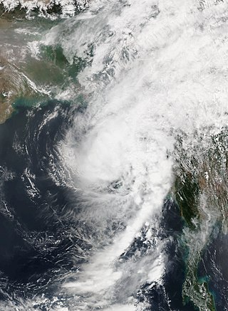
The 2004 Myanmar cyclone was considered the worst to strike the country since 1968. The second tropical cyclone of the 2004 North Indian Ocean cyclone season, it formed as a depression on May 16 in the central Bay of Bengal. With low wind shear and a surge in the monsoon trough, the storm intensified while meandering over open waters. The storm eventually began a steady northeastward motion due to a ridge to the north over India. While approaching land, an eye developed in the center of the storm, indicative of a strong cyclone. On May 19, the cyclone made landfall along northwestern Myanmar near Sittwe, with maximum sustained winds estimated at 165 km/h (105 mph) by the India Meteorological Department. The storm rapidly weakened over land, although its remnants spread rainfall into northern Thailand and Yunnan province in China.

<span class="mw-page-title-main">2015 North Indian Ocean cyclone season</span> North Indian Ocean tropical cyclone season

The 2015 North Indian Ocean cyclone season was an event in the annual cycle of tropical cyclone formation. The North Indian Ocean cyclone season has no official bounds, but cyclones tend to form between months of April and December, with the peak from May to November. These dates conventionally delimit the period of each year when most tropical cyclones form in the northern Indian Ocean.

<span class="mw-page-title-main">2018 North Indian Ocean cyclone season</span> North Indian Ocean tropical cyclone season

The 2018 North Indian Ocean cyclone season was one of the most active North Indian Ocean cyclone seasons since 1992, with the formation of fourteen depressions and seven cyclones. The North Indian Ocean cyclone season has no official bounds, but cyclones tend to form between April and December, with the two peaks in May and November. These dates conventionally delimit the period of each year when most tropical cyclones form in the northern Indian Ocean.

<span class="mw-page-title-main">Cyclone Maarutha</span>

Cyclonic Storm Maarutha was the first tropical cyclone to make landfall in Myanmar in April. The first tropical cyclone and named storm of the 2017 North Indian Ocean cyclone season, Maarutha was a relatively short-lived and weak system, nonetheless causing notable damage in Myanmar. Maarutha formed from an area of low pressure over the southern Bay of Bengal on April 15. The next morning, RSMC New Delhi upgraded the low-pressure area to a Depression and designated it as BOB 01.

References

  1. 1 2 3 4 5 6 7 8 9 A. B. Mazumdar; R. R. Lele; S. Sunitha Devi (July 2007). "Cyclones and depressions over the north Indian Ocean during 2006" (PDF). मौसम Mausam. 58 (3). India Meteorological Department: 305–322. doi:10.54302/mausam.v58i3.1325. S2CID   244699456. Archived from the original (PDF) on September 24, 2015. Retrieved May 7, 2014.
  2. Wallace Hogsett; Da-Lin Zhang (December 2010). "Genesis of Typhoon Chanchu (2006) from a Westerly Wind Burst Associated with the MJO. Part I: Evolution of a Vertically Tilted Precursor Vortex". Journal of the Atmospheric Sciences. 67 (12): 3774–3792. Bibcode:2010JAtS...67.3774H. doi: 10.1175/2010jas3446.1 .
  3. 1 2 3 O'Hara, J. F.; Falvey, Robert (2007). "Tropical Cyclone (TC) 02B (Mala)" (PDF). In Lana, Aaron (ed.). 2006 Annual Tropical Cyclone Report. Pearl Harbor: U.S. Naval Maritime Forecast Center / Joint Typhoon Warning Center. p. 44. Archived from the original (PDF) on February 21, 2013. Retrieved May 7, 2014.
  4. "Tropical Weather Outlook". India Meteorological Department. Unisys. April 24, 2006. Retrieved May 7, 2014.
  5. 1 2 3 4 5 "Tropical Cyclone 02B (Mala) Best Track". Joint Typhoon Warning Center. United States Navy. 2007. Archived from the original (.TXT) on October 9, 2012. Retrieved May 7, 2014.
  6. 1 2 "Tropical Cyclone Advisories for April 25, 2006 at 1800 UTC". Joint Typhoon Warning Center. Unisys. April 25, 2006. Retrieved May 7, 2014.
  7. "Tropical Cyclone Advisories for April 25, 2006 at 0600 UTC". Joint Typhoon Warning Center; India Meteorological Department. Unisys. April 25, 2006. Retrieved May 7, 2014.
  8. Kenneth R. Knapp; Michael C. Kruk; David H. Levinson; Howard J. Diamond; Charles J. Neumann (2010). 2006 Mala (2006114N08090). The International Best Track Archive for Climate Stewardship (IBTrACS): Unifying tropical cyclone best track data (Report). Bulletin of the American Meteorological Society. Archived from the original on March 5, 2016. Retrieved May 7, 2014.
  9. 1 2 "Bangladesh coast under cyclone warning". USA Today. Dhaka, Bangladesh. Associated Press. April 29, 2006. Retrieved May 8, 2014.
  10. "Tropical Cyclone Advisories for April 26, 2006 at 0600 UTC". Joint Typhoon Warning Center. Unisys. April 26, 2006. Retrieved May 7, 2014.
  11. 1 2 "Tropical Cyclone Advisories for April 27, 2006 at 0600 UTC". Joint Typhoon Warning Center. Unisys. April 25, 2006. Retrieved May 7, 2014.
  12. "Some characteristic features of cyclonic disturbances formed over the Indian Ocean and adjoining region during 2006" (PDF). WMO/ESCAP Panel on Tropical Cyclones 34th Session. World Meteorological Organization. November 15, 2007. p. 33. Retrieved May 7, 2014.
  13. Gary Padgett (May 5, 2006). "Global Tropical Cyclone Tracks – April 2006". Australia Severe Weather. Retrieved May 7, 2014.
  14. "Tropical Cyclone Advisories for April 28, 2006 at 1800 UTC". Joint Typhoon Warning Center. Unisys. April 25, 2006. Retrieved May 7, 2014.
  15. K.V.S. Badarinath; Shailesh Kumar Kharol; P.K. Dileep; V.K. Prasad (June 2009). "Satellite Observations on Cyclone-Induced Upper Ocean Cooling and Modulation of Surface Winds—A Study on Tropical Ocean Region". IEEE Geoscience and Remote Sensing Letters. 6 (3): 481–485. Bibcode:2009IGRSL...6..481B. doi:10.1109/LGRS.2009.2018487. ISSN   1545-598X. S2CID   29216997.
  16. Shailesh Kumar Kharol; K. V. S. Badarinath; Anu Rani Sharma; V. Krishna Prasad; Dimitrios G. Kaskaoutis; Panagiotis T. Nastos; Harry D. Kambezidis (May 7, 2010). "Impact of tropical cyclones on aerosol properties over urban region of Hyderabad, India" (PDF). Geophysical Research Abstracts. 12. NASA Astrophysics Data System: 12891. Bibcode:2010EGUGA..1212891K . Retrieved May 7, 2014.
  17. "Special Storm Warning". The New Light of Myanmar. Yangon, Myanmar. April 26, 2006.
  18. 1 2 "Cyclone Mala reaches western Myanmar". Yangon, Myanmar. Agence France-Presse. April 29, 2006 via Lexis Nexis.
  19. 1 2 3 Myanmar: Cyclone Mala Final Report for DREF Bulletin no. MDRMM01 (PDF). International Federation of Red Cross and Red Crescent Societies (Report). ReliefWeb. February 15, 2007. Retrieved May 6, 2014.
  20. "Storm Warning". The New Light of Myanmar. Yangon, Myanmar. April 29, 2006.
  21. "Cyclone spares Bangladesh, hits Burmese coast". The Daily Star. Dhaka, Bangladesh: British Broadcasting Company. May 1, 2006.
  22. Chiang Mai (May 3, 2006). "Early rains in North 'a sign of La Niña and wet year'". The Nation.  via Lexis Nexis (subscription required)
  23. "Myanmar: 2006 Progress Report" (PDF). International Federation of Red Cross And Red Crescent Societies. ReliefWeb. December 31, 2006. Retrieved May 8, 2014.
  24. 1 2 Ministry of Social Welfare, Relief and Resettlement and the Ministry of Education (2008). "Natural Disasters in Myanmar" (PDF). Guidance on Mainstreaming Disaster Risk Reduction in the Education Sector, Myanmar – Rural Settings. Myanmar Information Management Unit. p. 16. Retrieved May 7, 2014.
  25. Tint Zaw; Mu Mu Than (March 2010). "Climate Change Impacts to the Water Environment and Adaptation Options" (PDF). Union of Myanmar Ministry of Agriculture and Irrigation. Water Environment Partnership in Asia. p. 9. Retrieved May 7, 2014.
  26. 1 2 "Myanmar: Cyclone Mala DREF Bulletin MDRMM001 Update No. 2". International Federation of Red Cross And Red Crescent Societies. ReliefWeb. November 6, 2006. Retrieved May 8, 2014.
  27. 1 2 3 4 5 6 "Myanmar: Cyclone Mala Information Bulletin No. 1". International Federation of Red Cross And Red Crescent Societies. ReliefWeb. May 3, 2006. Retrieved May 6, 2014.
  28. "Myanmar authorities put on alert after cyclone destroys homes in southwestern delta region". Yangon, Myanmar. Associated Press International. April 28, 2006 via Lexis Nexis.
  29. 1 2 "Cyclone Mala kills two in Burma". The Nation. Yangon, Myanmar. Associated Press. May 1, 2006. p. 4A. Retrieved May 6, 2014.
  30. 1 2 "Cyclone Mala kills one and injures 21 in Myanmar". Yangon, Myanmar. Agence France-Presse. April 30, 2006 via Lexis Nexis.
  31. "Myanmar: Commander, Minister donate relief supplies to cyclone victims in Ayeyawady Division". Government of Myanmar. ReliefWeb. May 1, 2006. Retrieved May 6, 2014.
  32. "Myanmar: Relief provided to cyclone victims". Government of Myanmar. ReliefWeb. May 3, 2006. Retrieved May 6, 2014.
  33. "Cyclone Mala leaves 18 drowned, 14 missing in Kyangin". The New Light of Myanmar. Nay Pyi Taw, Myanmar. May 3, 2006.
  34. "Myanmar: Cyclone Mala DREF Bulletin MDRMM001 Final Report" (PDF). International Federation of Red Cross And Red Crescent Societies. ReliefWeb. February 15, 2007. Retrieved May 8, 2014.
Extremely Severe Cyclonic Storm Mala
Cyclone Mala 28 apr 2006 0405Z.jpg
Cyclone Mala on April 28, near peak intensity