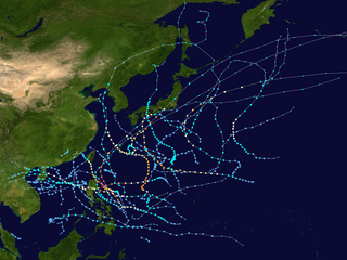
Cyclone Giri

Last updated
Map key
  Tropical depression (≤38 mph, ≤62 km/h)
  Tropical storm (39–73 mph, 63–118 km/h)
  Category 1 (74–95 mph, 119–153 km/h)
  Category 2 (96–110 mph, 154–177 km/h)
  Category 3 (111–129 mph, 178–208 km/h)
  Category 4 (130–156 mph, 209–251 km/h)
  Category 5 (≥157 mph, ≥252 km/h)
  Unknown
Storm type
Disc Plain black.svg Tropical cyclone
Solid black.svg Subtropical cyclone
ArrowUp.svg Extratropical cyclone, remnant low, tropical disturbance, or monsoon depression

Cyclone Giri was first identified by the India Meteorological Department (IMD) as an area of low pressure over the Bay of Bengal on October 19. Early on October 20, the system was classified as a depression and given the name BOB 04; and at that time, the system was situated roughly 250 km (155 mi) southwest of Sittwe, Myanmar. [1] Continued development took place as convection consolidated around the system and banding features formed along the western side of the low. As the depression was situated in an area of weak wind shear, further development was anticipated over the following days. [2] Early on October 21, the IMD upgraded the system to a deep depression and expected it to further intensify into a cyclonic storm within 24 hours. [3] Shortly thereafter, the Joint Typhoon Warning Center (JTWC) issued their first advisory on the depression, classifying it as Tropical Cyclone 04B. The system rapidly developed throughout the day on October 21, developing an eye embedded within deep convection. In response to a near-equatorial ridge to the south, the system slowly tracked towards the northeast, placing Myanmar within its path. [4] Around 0600  UTC, the IMD upgraded the system to a cyclonic storm, assigning it the name "Giri". [5]

Tracking over an area of high sea surface temperatures, rapid intensification ensued during the latter half of October 21. [6] Following the development of very intense convection, with estimated cloud top temperatures between −70 and −80 °C (−94 and −112 °F), Giri strengthened into a severe cyclonic storm, having sustained winds of at least 95 km/h (60 mph 3-minute sustained). [7] Around 1800 UTC, the JTWC estimated that the system intensified into a Category 1 equivalent cyclone on the Saffir–Simpson hurricane scale. [8] Early on October 22, Giri further strengthened into a very severe cyclonic storm as it slowly moved towards the central coast of Myanmar. [9] Throughout the day, the storm underwent explosive deepening, attaining winds of 240 km/h (145 mph 1-minute sustained) by 0900 UTC. Satellite imagery depicted a well-defined 46 km (29 mi) wide eye surrounded by deep convection. Accompanied by strong poleward outflow, additional strengthening took place despite Giri's proximity to land. [10]

In the hours before landfall on October 22, Giri attained its peak intensity with winds of 165 km/h (105 mph 3-minute sustained) and a barometric pressure of 950 mbar (hPa; 28.05 inHg). [11] However, the JTWC estimated that Giri was a substantially stronger storm, nearly attaining Category 5 status; peak winds were believed to have reached 250 km/h (155 mph 1-minute sustained) along with an estimated pressure of 922 mbar (hPa; 27.23 inHg). [12] Around 1400 UTC, Cyclone Giri made landfall near Hunter's Bay, roughly 50 km (31 mi) northwest of Kyaukpyu at peak intensity. [13] Upon doing so, Giri became the most intense storm to ever strike Myanmar, surpassing Cyclone Nargis which struck the Irrawaddy Delta region as a low-end Category 4 equivalent in May 2008. [14] However, according to the International Federation of Red Cross And Red Crescent Societies, substantial weakening had taken place within the hours before landfall; they estimated that Cyclone Giri struck the coastline with winds of 175 km/h (110 mph 1-minute sustained). [15] Once overland, the cyclone rapidly decayed as convection dissipated. [16] By early October 23, only scattered bursts of convection remained around the center of Giri as it degenerated into a tropical depression. [17] The final advisory from the IMD was issued later that day as the system weakened further. [18]

Preparations

Shortly after Giri was classified a very severe cyclonic storm, warnings were issued for the coastline of Myanmar. Relative to the storm's intensity, preparations were minimal; however, this was because forecasters did not anticipate Giri to strengthen as quickly as it did. [19] The greatest fear of the residents was the aftermath of the storm. There were concerns that the cyclone could cause devastation similar to that of Cyclone Nargis in May 2008 which killed an estimated 140,000 people in the Irrawaddy Delta. [20] The chief of the Myanmar Climate Change Watch, a branch within the Myanmar Meteorology and Hydrology Department, urged people to move to higher grounds and into sturdy buildings as a storm surge up to 3.6 m (12 ft) was anticipated. Warnings of the storm were constantly broadcast through television, radio and newspapers. In Sittwe, the capital of Rakhine State, authorities used loudspeakers to warn residents about Cyclone Giri. [21] According to the military junta, an estimated 53,000 are believed to have evacuated Kyaukphyu before the arrival of the storm. [22]

Even though the storm wasn't expected to hit Bangladesh, the Bangladesh Meteorological Department issued storm signal five, "danger level", at ports of Cox's Bazar and Chittagong. [23] Ships and vessels were also asked to return to shore quickly. [24] On October 23, the warning signals were lowered as the threat from Giri diminished. [25]

Impact

According to local media, Cyclone Giri brought a storm surge up to 3.7 m (12 ft), along with waves up to 8 m (26 ft) and winds in excess of 260 km/h (160 mph). [26] In Kyaukphyu, much of the city was left more than 1.2 m (3.9 ft) under water by the storm. Residents stated that most of Kyaukphyu was destroyed by Giri, with nearly every tree and lamppost felled and all structures damaged or destroyed. [27] Later reports confirmed that roughly 70% of the city had been destroyed by Giri. [28] In the Ashey Paing ward, an entire village was flattened by the storm as roughly 1,000 homes were destroyed. Near the Gangawtaw Pagoda in Kyaukphyu, nearly 100 homes were completely destroyed. [27] The local Red Cross office in the city was also destroyed after a large tree fell on it due to high winds. [29] Myebon Township was the hardest-hit area in the country: several villages were completely destroyed by the storm and many others were severely damaged. [30] According to the United Nations, roughly 15,000 homes were destroyed by the storm throughout Rakhine State. [31]

In the Seikphyu Township, flood waters up to 4.6 m (15 ft) deep inundated 20 villages after overflow from a dam was released without warning. Of the few reports coming from the region, there were indications of fatalities in outlying villages. Most of the livestock in the area perished as there was no time to bring them to higher ground safely. [32] The overall timing of the cyclone's landfall was also devastating for the region. It came at the only harvest of the year for Rakhine State. According to the United Nations Food and Agriculture Organization, 16,187 hectares (40,000 acres) of rice paddies were destroyed and another 40,468 hectares (100,000 acres) were damaged. [33]

Within a day of Giri striking Myanmar, three people were reported to have been killed by the storm and tens of thousands of residents were believed to have been left homeless. [27] By October 25, officials in Myanmar stated that the death toll had risen to 50 and at least 30 people in the Pyin Wan Village were missing. Press reports stated that "The situation here is alarming", as more bodies were discovered. [34] Offshore, more than 100 fishermen from Myanmar and Bangladesh were reported missing after 21 ships were caught in rough seas produced by the cyclone. [26] By October 29, at least 94 people were confirmed to have been killed by Giri. Of these fatalities, 84 were in Myebon Township (Mray Bon) and 10 in Pauktaw Township. [35] [36] However, according to local relief groups, the death toll had risen over 100. [31]

By November 2, 157 fatalities had been confirmed as a result of Cyclone Giri. Of these fatalities, 138 were in Myebon Township, 11 in Pauktaw Township, 5 in Minbya Township and 3 in Kyaukpyu Township. [37] According to officials in Kyaukpyu Township, damage from the storm amounted to Ks.2.34 billion (US$359 million). [38]

Aftermath

Immediately following the storm, urgent requests for food and clean water were made by residents in the hardest hit areas. By the afternoon of October 23, the Red Cross began deploying relief supplies to the affected region; 300 tents and 150 bags of rice were planned to be distributed to Kyaukphyu where at least 5,000 people were left homeless. [39] According to the United Nations Office for the Coordination of Humanitarian Affairs (OCHA), a total of 176,823 people were affected by the storm and 70,795 were left homeless. [40] By October 30, the number affected and homeless had risen to 1.1 million and roughly 100,000 respectively. [41] [42] Red Cross officials also reported that an estimated 60,000 people were in need of assistance throughout Myanmar. [29] Later that day, a relief charity was opened in Rangoon to aid victims of the storm; in short order, the charity had received donations of Ks.10 million ($10,000  USD). [43] By October 25, temporary shelter camps set up by relief agencies housed an estimated 5,000 people. [44]

By October 26, the Government of the Union of Myanmar had begun distributing 60,000 zinc roof sheets and the Ministry of Forestry provided 200 tonnes (220 tons) of timber. Through the end of October, six non-governmental organizations in Myanmar planned to distribute emergency food supplies, such rice, oil, salt and pulses, to 5,000 residents in Kyaukpyu and Myebon. Health supplies were also being distributed at relief camps by UNICEF in the hardest-hit areas. About 500 family kits containing non-food items, such as tarpaulins and mosquito nets, had been distributed by the Myanmar Red Cross Society and another 1,200 were being sent to the area. [40] By the start of November, the government of Myanmar requested medial aid from the United Nations as a cholera outbreak began to unfold. Additional post-storm diseases such as diarrhoea, dysentery, eye infections and skin diseases became prevalent as well. According to locals, at least six people died as a result of cholera. [45] At least 200 people were infected with dysentery and four were killed by the disease in the towns of Kyaukphyu, Minbya and Myebon. The cause of the outbreak was linked to a lack of clean water. [46]

International assistance

On October 26, United States Secretary of State Hillary Clinton stated that the country would provide emergency assistance and aid to Myanmar. [47] Roughly a week after the passage of Cyclone Giri, the government of Australia pledged about US$200,000 to victims of the storm. The governments of Britain and Japan also pledged to donate US$700,000 and US$500,000 respectively to Myanmar. [48] The World Food Programme sent 900 tonnes (992 tons) of rice with another 300 tonnes (330 tons) on the way; stocks of rice in Kyaukpyu itself had reportedly been exhausted. [40] By late-November, the World Food Programme had allocated US$2.8 million in relief funds. [48] Roughly 1,500 households in Kyaukpyu township were being cared for by Save the Children. [40] Through the United Nations, organizations pledged to provide a total of US$54 million in aid. In late-November, the United States provided an additional US$3 million in relief funds. [48]

Criticism of the Junta

International and local media criticized the military government for inadequate warnings prior to Giri's landfall in the country. However, the junta claims to have informed the public appropriately. [44] Little assistance had reached thousands of survivors days after the storm's passage, fueling anger from local media sources. Government relief slowly reached the area; however, workers only cleared debris left by the storm and only encouraged residents to rebuild by giving them the supplies needed to do so. [28] Further criticism was made about the government withholding information on the loss of life and scale of damage. [49] Requests were also made to postpone a national election for residents in Arakan State; [31] however, no response was given and the elections were still planned to be held on November 7. [41]

Additional criticism continued even a week after the storm, especially over the scale of the disaster. The government claimed that only 27 people had been killed by Giri while numerous local and international agencies stated significantly higher totals. They were also blamed for downplaying the amount of damage, resulting in slower distribution of aid to areas in desperate need. [31] Two weeks after Giri struck Myanmar, little attention was given to the ongoing disaster by the Junta. The Myanmar government continued to keep other countries out of the area and prevent them from knowing what was going on in the hardest hit areas. Thousands of survivors continued to suffer due to the insufficient relief making it into the region. [50] On November 8, local media discovered that the junta was threatening to sever aid to the region if residents did not vote for them in the national election. According to Mizzima, the opposing party won landslide victories in numerous townships; however, in the cyclone affected areas, the Junta had complete victories. [51]

See also

Related Research Articles

<span class="mw-page-title-main">Cyclone Mala</span> North Indian Ocean extremely severe cyclonic storm in 2006

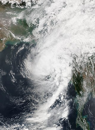
Extremely Severe Cyclonic Storm Mala was the strongest tropical cyclone of the 2006 North Indian Ocean cyclone season. In mid-April 2006, an area of disturbed weather formed over the southern Bay of Bengal and nearby Andaman Sea. Over a period of several days, the system became increasingly organized and was classified as a depression on April 24. Situated within a region of weak steering currents, the storm slowly intensified as it drifted in a general northward direction. It attained gale-force winds and was named Mala the next day. Conditions for strengthening improved markedly on April 27 and Mala subsequently underwent rapid intensification which culminated in the cyclone attaining its peak. Early on April 28, the cyclone had estimated winds of 185 km/h (115 mph). The Joint Typhoon Warning Center considered Mala to have been slightly stronger, classifying it as a Category 4-equivalent cyclone. Steady weakening ensued thereafter and the storm made landfall in Myanmar's Rakhine State on April 29. Rapid dissipation took place once onshore and Mala was last noted early the next morning.

<span class="mw-page-title-main">2008 Pacific typhoon season</span> Typhoon season in the Western Pacific Ocean

The 2008 Pacific typhoon season was a below average season which featured 22 named storms, eleven typhoons, and two super typhoons. The season had no official bounds; it ran year-round in 2008, but most tropical cyclones tend to form in the northwestern Pacific Ocean between May and November. These dates conventionally delimit the period of each year when most tropical cyclones form in the northwestern Pacific Ocean.

<span class="mw-page-title-main">2008 North Indian Ocean cyclone season</span> North Indian Ocean tropical cyclone season

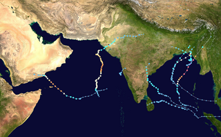
The 2008 North Indian cyclone season was one of the most disastrous tropical cyclone seasons in modern history, with tropical cyclones leaving more than 140,000 people dead and causing more than US$15 billion in damage, making it the costliest season in the North Indian Ocean, until it was made second in 2020. The season has no official bounds but cyclones tend to form between April and December. These dates conventionally delimit the period of each year when most tropical cyclones form in the northern Indian Ocean. There are two main seas in the North Indian Ocean—the Bay of Bengal to the east of the Indian subcontinent and the Arabian Sea to the west of India. The official Regional Specialized Meteorological Centre in this basin is the India Meteorological Department (IMD), while the Joint Typhoon Warning Center releases unofficial advisories. An average of four to six storms form in the North Indian Ocean every season with peaks in May and November. Cyclones occurring between the meridians 45°E and 100°E are included in the season by the IMD.

<span class="mw-page-title-main">Cyclone Akash</span> North Indian Ocean cyclonic storm in 2007

Cyclonic Storm Akash was the first named tropical cyclone of the 2007 North Indian Ocean cyclone season. Warned by both India Meteorological Department (IMD) and Joint Typhoon Warning Center (JTWC), it formed from an area of disturbed weather on the Bay of Bengal on May 12, and gradually organized as it drifted northward. An eye began to develop as it approached land, and after reaching peak 3-min sustained winds of 85 km/h (55 mph) it struck about 115 km (71 mi) south of Chittagong in Bangladesh. Akash rapidly weakened over land, and advisories were discontinued on May 15.

<span class="mw-page-title-main">Timeline of the 2007 North Indian Ocean cyclone season</span>

Below is a timeline of the 2007 North Indian Ocean cyclone season, documenting major events with regards to tropical cyclone formation, strengthening, weakening, landfall, extratropical transition, as well as dissipation. The 2007 North Indian Ocean cyclone season was an ongoing event in the annual cycle of tropical cyclone formation.

<span class="mw-page-title-main">1999 North Indian Ocean cyclone season</span> Cyclone season in the North Indian ocean

The 1999 North Indian Ocean cyclone season was an event in the annual cycle of tropical cyclone formation. The North Indian Ocean cyclone season has no official bounds, but cyclones tend to form between April and December, with peaks in May and November. These dates conventionally delimit the period of each year when most tropical cyclones form in the northern Indian Ocean.

<span class="mw-page-title-main">Timeline of the 2008 North Indian Ocean cyclone season</span>

The 2008 North Indian Ocean cyclone season officially ran throughout the year during 2008, with the first depression forming on April 27. The timeline includes information that was not operationally released, meaning that information from post-storm reviews by the Joint Typhoon Warning Center (JTWC), and the India Meteorological Department (IMD), such as information on a storm that was not operationally warned on. This timeline documents all the storm formations, strengthening, weakening, landfalls, extratropical transitions, as well as dissipation's during the 2008 North Indian Ocean cyclone season.

<span class="mw-page-title-main">2009 North Indian Ocean cyclone season</span> North Indian Ocean tropical cyclone season

The 2009 North Indian Ocean cyclone season was an event in the annual cycle of tropical cyclone formation. The North Indian Ocean cyclone season has no official bounds, but cyclones tend to form between April and December, with peaks in May and November. These dates conventionally delimit the period of each year when most tropical cyclones form in the northern Indian Ocean.

<span class="mw-page-title-main">Cyclone Rashmi</span>

Cyclonic Storm Rashmi was the seventh tropical cyclone of the 2008 North Indian Ocean cyclone season and second cyclonic storm, as well as the fifth tropical cyclone in the Bay of Bengal that year. A fairly weak tropical cyclone, it caused some notable damage in Bangladesh and India.

<span class="mw-page-title-main">Cyclone Monica</span> Category 5 Australian region cyclone in 2006

Severe Tropical Cyclone Monica was the most intense tropical cyclone, in terms of maximum sustained winds, on record to impact Australia. The 17th and final storm of the 2005–06 Australian region cyclone season, Monica originated from an area of low pressure off the coast of Papua New Guinea on 16 April 2006. The storm quickly developed into a Category 1 cyclone the next day, at which time it was given the name Monica. Travelling towards the west, the storm intensified into a severe tropical cyclone before making landfall in Far North Queensland, near Lockhart River, on 19 April 2006. After moving over land, convection associated with the storm quickly became disorganised.

<span class="mw-page-title-main">2010 North Indian Ocean cyclone season</span> North Indian Ocean tropical cyclone season

The 2010 North Indian Ocean cyclone season was one of the most active tropical cyclone season in the North Indian Ocean since 1998. The season saw 8 depressions and 5 named storms forming in the region.

<span class="mw-page-title-main">2016 Pacific typhoon season</span> Typhoon season in the Western Pacific Ocean

The 2016 Pacific typhoon season is considered to have been the fourth-latest start for a Pacific typhoon season since reliable records began. It was an average season, with a total of 26 named storms, 13 typhoons, and six super typhoons. The season ran throughout 2016, though typically most tropical cyclones develop between May and October. The season's first named storm, Nepartak, developed on July 3, while the season's last named storm, Nock-ten, dissipated on December 28.

<span class="mw-page-title-main">Tropical cyclones in Myanmar</span>

At least 29 tropical cyclones have affected Myanmar, a country adjacent to the Bay of Bengal in mainland Southeast Asia. Myanmar has witnessed some of the deadliest storms in the Bay of Bengal, including Cyclone Nargis in May 2008, which struck the low-lying Irrawaddy Delta near Yangon. Its winds and storm surge killed an estimated 140,000 people and left nearly $10 billion in damage. The country's worst natural disaster in the 20th century was a cyclone in 1968, which killed more than 1,000 people when it hit Rakhine State in northwestern Myanmar. One of the most powerful storms to ever hit the country was Cyclone Mocha, which it moved ashore northwestern Myanmar in May 2023, killing at least 413 people.

<span class="mw-page-title-main">2013 North Indian Ocean cyclone season</span> North Indian Ocean tropical cyclone season

The 2013 North Indian Ocean cyclone season was an event in the annual cycle of tropical cyclone formation, in which tropical cyclones formed in the North Indian Ocean and Arabian Sea. The season had no official bounds, but cyclones typically formed between May and December, with the peak from October to November. These dates conventionally delimit the period of each year when most tropical cyclones form in the northern Indian Ocean.

<span class="mw-page-title-main">Cyclone Viyaru</span> North Indian Ocean cyclone in 2013

Cyclonic Storm Viyaru, operationally known as Cyclonic Storm Mahasen, was a relatively weak tropical cyclone that caused loss of life across six countries in Southern and Southeastern Asia. Originating from an area of low pressure over the southern Bay of Bengal in early May 2013, Viyaru slowly consolidated into a depression on May 10. The depression gained forward momentum and attained gale-force winds on May 11 and was designated as Cyclonic Storm Viyaru, the first named storm of the season. Owing to adverse atmospheric conditions, the depression struggled to maintain organized convection as it moved closer to eastern India. On May 14, the exposed circulation of Viyaru turned northeastward. The following day, conditions again allowed for the storm to intensify. Early on May 16, the cyclone attained its peak intensity with winds of 85 km/h (55 mph) and a barometric pressure of 990 mbar. Shortly thereafter Viyaru made landfall near Chittagong, Bangladesh. On May 17, it moved over the eastern Indian state of Nagaland.

<span class="mw-page-title-main">Deep Depression ARB 01 (2013)</span>

Deep Depression ARB 01 was the second deadliest tropical cyclone worldwide in 2013 as well as the deadliest to affect Somalia in recorded history. The sixth tropical cyclone and third deep depression of the 2013 North Indian Ocean cyclone season, ARB 01 formed in the Arabian Sea on November 8. The cyclone subsequently strengthened into a deep depression before making landfall in the Puntland region of Somalia at peak intensity on November 11. After making landfall, the cyclone rapidly weakened over land and degenerated into a well-marked low-pressure area later on the same day.

<span class="mw-page-title-main">2017 North Indian Ocean cyclone season</span> North Indian Ocean tropical cyclone season

The 2017 North Indian Ocean cyclone season was a below average yet deadly season in the annual cycle of tropical cyclone formation. This season produced only three named storms, of which one only intensified into a very severe cyclonic storm. The North Indian Ocean cyclone season has no official bounds but cyclones tend to form between April and December with the two peaks in May and November. These dates conventionally delimit the period of each year when most tropical cyclones form in the northern Indian Ocean. The season began with the formation Cyclone Maarutha on April 15 and ended with the dissipation of a deep depression on December 9.

<span class="mw-page-title-main">Cyclone Maarutha</span>

Cyclonic Storm Maarutha was the first tropical cyclone to make landfall in Myanmar in April. The first tropical cyclone and named storm of the 2017 North Indian Ocean cyclone season, Maarutha was a relatively short-lived and weak system, nonetheless causing notable damage in Myanmar. Maarutha formed from an area of low pressure over the southern Bay of Bengal on April 15. The next morning, RSMC New Delhi upgraded the low-pressure area to a Depression and designated it as BOB 01.
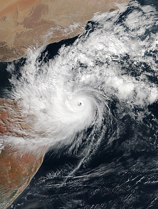
<span class="mw-page-title-main">2021 Pacific typhoon season</span> Typhoon season in the Western Pacific Ocean

The 2021 Pacific typhoon season was the second consecutive to have below-average tropical cyclone activity, with twenty-two named storms, and was the least active since 2011. Nine became typhoons, and five of those intensified into super typhoons. This low activity was caused by a strong La Niña that had persisted from the previous year. The season's first named storm, Dujuan, developed on February 16, while the last named storm, Rai, dissipated on December 21. The season's first typhoon, Surigae, reached typhoon status on April 16. It became the first super typhoon of the year on the next day, also becoming the strongest tropical cyclone in 2021. Surigae was also the most powerful tropical cyclone on record in the Northern Hemisphere for the month of April. Typhoons In-fa and Rai are responsible for more than half of the total damage this season, adding up to a combined total of $2.02 billion.

<span class="mw-page-title-main">2023 North Indian Ocean cyclone season</span> North Indian Ocean tropical cyclone season

The 2023 North Indian Ocean cyclone season was a very active season, featuring the second-highest accumulated cyclone energy (ACE) on record for the basin, only behind 2019. The North Indian Ocean cyclone season has no official bounds, but cyclones tend to form between April and December, with the peak from May to November. These dates conventionally delimit the period of each year when most tropical cyclones form in the northern Indian Ocean. However, a cyclone can form at any time during the year shown by an unnamed depression that affected Sri Lanka in January-February.

References

  1. "Depression over east-central Bay of Bengal". India Meteorological Department. October 20, 2010. Archived from the original on December 4, 2010. Retrieved October 23, 2010.
  2. "Significant Tropical Weather Outlook for the Indian Ocean". Joint Typhoon Warning Center. October 20, 2010. Archived from the original on August 8, 2010. Retrieved October 23, 2010.
  3. "Deep Depression over east-central Bay of Bengal". India Meteorological Department. October 21, 2010. Archived from the original on December 4, 2010. Retrieved October 23, 2010.
  4. "Tropical Cyclone 04B Advisory One". Joint Typhoon Warning Center. October 21, 2010. Archived from the original on December 3, 2010. Retrieved October 23, 2010.
  5. "Cyclonic storm "Giri" over east-central Bay of Bengal". India Meteorological Department. October 21, 2010. Archived from the original on December 4, 2010. Retrieved October 23, 2010.
  6. "Tropical Cyclone 04B Advisory Two". Joint Typhoon Warning Center. October 21, 2010. Archived from the original on December 3, 2010. Retrieved October 23, 2010.
  7. "Tropical Storm Giri Advisory Six". India Meteorological Department. October 21, 2010. Archived from the original on December 4, 2010. Retrieved October 23, 2010.
  8. "Tropical Cyclone 04B (Giri) Advisory Four". Joint Typhoon Warning Center. October 21, 2010. Archived from the original on December 3, 2010. Retrieved October 23, 2010.
  9. "Very Severe Cyclonic storm "Giri" over east-central & adjoining northeast Bay of Bengal". India Meteorological Department. October 22, 2010. Archived from the original on December 4, 2010. Retrieved October 23, 2010.
  10. "Tropical Cyclone 04B (Giri) Advisory Six". Joint Typhoon Warning Center. October 22, 2010. Archived from the original on December 3, 2010. Retrieved October 23, 2010.
  11. "Tropical Storm Giri Advisory Ten". India Meteorological Department. October 22, 2010. Archived from the original on December 4, 2010. Retrieved October 23, 2010.
  12. "Tropical Cyclone 04B (Giri) Advisory Seven". Joint Typhoon Warning Center. October 22, 2010. Archived from the original on December 3, 2010. Retrieved October 23, 2010.
  13. "Very Severe Cyclonic storm "Giri" over northeast Bay of Bengal". India Meteorological Department. October 22, 2010. Archived from the original on December 4, 2010. Retrieved October 23, 2010.
  14. Jeff Masters (October 22, 2010). "Little change to Richard; Giri strongest cyclone ever to hit Myanmar; Megi nears China". Weather Underground. Retrieved October 23, 2010.
  15. International Federation of Red Cross And Red Crescent Societies (October 24, 2010). "Myanmar: Cyclone Giri Information bulletin n° 1, 24 October 2010". ReliefWeb. Retrieved October 25, 2010.
  16. "Tropical Cyclone 04B (Giri) Advisory Eight (Final)". Joint Typhoon Warning Center. October 22, 2010. Archived from the original on December 3, 2010. Retrieved October 23, 2010.
  17. "Tropical Storm Giri Advisory Seventeen". India Meteorological Department. October 23, 2010. Archived from the original on December 4, 2010. Retrieved October 23, 2010.
  18. "Tropical Storm Giri Advisory Eighteen (Final)". India Meteorological Department. October 23, 2010. Archived from the original on December 4, 2010. Retrieved October 23, 2010.
  19. "Cyclone Giri likely to cross Myanmar coast on Friday night". NetIndian News Network. Retrieved 22 October 2010.
  20. "Western Burma battens down as Cyclone Giri lashes coast". Mizzima News. Archived from the original on 24 October 2010. Retrieved 22 October 2010.
  21. "Cyclone Giri forecast to hit Myanmar on Saturday". USA Today. October 24, 2010. Retrieved 22 October 2010.
  22. "27 Were Killed in Cyclone, Myanmar Government Says". The New York Times. The Associated Press. October 25, 2010. Archived from the original on April 30, 2018. Retrieved October 26, 2010.
  23. "6-8 feet surge may hit Cox's Bazar". bdnews24.com. Archived from the original on 22 July 2011. Retrieved 22 October 2010.
  24. "Bangladesh on alert as cyclone nears coast". Reuters. Retrieved 22 October 2010.
  25. "Cox's Bazar maritime port asked to lower signal". The Daily Star. Archived from the original on 30 June 2018. Retrieved 23 October 2010.
  26. 1 2 Indo-Asian News Service (October 23, 2010). "100 fishermen missing as Cyclone Giri strikes". Hindustan Times. Archived from the original on November 9, 2010. Retrieved October 23, 2010.
  27. 1 2 3 Staff Writer (October 23, 2010). "Cyclone Giri flattens coastal towns". Democratic Voice of Burma. Archived from the original on October 24, 2010. Retrieved October 23, 2010.
  28. 1 2 Democratic Voice of Burma (October 25, 2010). "Death toll rises on cyclone-hit coast". ReliefWeb. Retrieved October 25, 2010.
  29. 1 2 PTI (October 23, 2010). "Myanmar cyclone leaves at least one dead, thousands affected". Zee News. Archived from the original on June 7, 2022. Retrieved October 23, 2010.
  30. "At least 12 people die in cyclone Giri in Myanmar: local media". People's Daily Online. Xinhua. October 25, 2010. Archived from the original on June 29, 2018. Retrieved October 25, 2010.
  31. 1 2 3 4 Ba Kaung (October 30, 2010). "Relief Efforts Slow to Reach Arakan's Devastated Coast". The Irrawaddy. Archived from the original on October 30, 2010. Retrieved October 30, 2010.
  32. Ko Htwe (October 29, 2010). "Flash floods Hit Pakokku". The Irrawaddy. Archived from the original on November 3, 2010. Retrieved October 30, 2010.
  33. Staff Writer (November 8, 2010). "Urgent need to rebuild livelihoods after Giri". Integrated Regional Information Networks. Archived from the original on November 25, 2010. Retrieved November 8, 2010.
  34. Staff Writer (October 25, 2010). "Death Toll Rises and Thousands Left Homeless in Giri Aftermath". Narinjara. Archived from the original on November 5, 2010. Retrieved October 25, 2010.
  35. Ba Kaung (October 26, 2010). "Cyclone Death Toll Increases to 84". The Irrawaddy. Archived from the original on October 26, 2010. Retrieved October 26, 2010.
  36. Staff Writer (October 29, 2010). "List of Deceased from Cyclone Giri in Mray Bon Township". Narinja. Archived from the original on November 5, 2010. Retrieved October 30, 2010.
  37. "List of Damages and Deceased Caused by Cyclone Giri in Pauktaw Township". Narinjara. November 2, 2010. Archived from the original on November 5, 2010. Retrieved November 2, 2010.
  38. Than Htike Oo (November 5, 2010). "Housing and livelihoods top priorities for Giri victims". Myanmar Times. Archived from the original on November 10, 2010. Retrieved November 5, 2010.
  39. Staff Writer (October 23, 2010). "Relief Urgently Needed as Cyclone Giri Leaves Dozens Missing". The Irrawaddy. Archived from the original on December 21, 2010. Retrieved October 23, 2010.
  40. 1 2 3 4 United Nations Office for the Coordination of Humanitarian Affairs (October 26, 2010). "Myanmar: Cyclonic Storm Giri Situation Report # 3, 26 October 2010" (PDF). ReliefWeb. Retrieved October 26, 2010.
  41. 1 2 Staff Writer (October 30, 2010). "Urgent Appeal for Cyclone Victims in Arakan". Narinja. Archived from the original on November 5, 2010. Retrieved October 30, 2010.
  42. Staff Writer (October 28, 2010). "IRC responds after Cyclone Giri batters Myanmar". International Rescue Committee. Archived from the original on October 31, 2010. Retrieved October 30, 2010.
  43. Staff Writer (October 23, 2010). "Cyclone damage spurs calls for aid as 3,000 homes suffer". Mizzima News. Archived from the original on October 24, 2010. Retrieved October 23, 2010.
  44. 1 2 Staff Writer (October 25, 2010). "Cyclone Giri pummels west Burma". BBC News. Archived from the original on October 28, 2010. Retrieved October 25, 2010.
  45. Thea Forbes (November 1, 2010). "Regime seeks UN agencies' help with Giri medical aid". Mizzima News. Archived from the original on November 30, 2010. Retrieved November 27, 2010.
  46. Staff Writer (November 1, 2010). "Post-cyclone dysentery kills 4". Democratic Voice of Burma. Archived from the original on November 24, 2010.
  47. Staff Writer (October 26, 2010). "US offers aid to cyclone-hit Myanmar". Agence-France-Presse. Archived from the original on October 26, 2010. Retrieved October 26, 2010.
  48. 1 2 3 Kyaw Kha (November 25, 2010). "US donates further US$3m for Cyclone Giri victims". Mizzima News. Archived from the original on November 29, 2010. Retrieved November 27, 2010.
  49. "Myanmar mum on cyclone damage". Independent Online. The Associated Press. October 25, 2010. Archived from the original on June 28, 2018. Retrieved October 26, 2010.
  50. "Burma cyclone ignored, government quiet". Mission Network News. November 8, 2010. Archived from the original on November 10, 2010. Retrieved November 8, 2010.
  51. Thea Forbes (November 8, 2010). "Junta held storm victims' aid as ransom for votes". Mizzima News. Archived from the original on November 8, 2010. Retrieved November 8, 2010.
Extremely Severe Cyclonic Storm Giri
Giri 2010-10-22 0655Z.jpg
Cyclone Giri near peak intensity on October 22