Meteorological history | |
---|---|
Formed | November 29,2017 |
Extratropical | December 4,2017 |
Dissipated | December 6,2017 |
Very severe cyclonic storm | |
3-minute sustained (IMD) | |
Highest winds | 155 km/h (100 mph) |
Lowest pressure | 976 hPa (mbar);28.82 inHg |
Category 3-equivalent tropical cyclone | |
1-minute sustained (SSHWS/JTWC) | |
Highest winds | 185 km/h (115 mph) |
Lowest pressure | 948 hPa (mbar);27.99 inHg |
Overall effects | |
Fatalities | 318 |
Missing | 141 |
Damage | $920 million (2017 USD) |
Areas affected | Southern India,Sri Lanka and Maldives |
IBTrACS | |
Part of the 2017 North Indian Ocean cyclone season |
Very Severe Cyclonic Storm Ockhi [nb 1] was a strong tropical cyclone that devastated parts of Sri Lanka and India in 2017,and was the most intense tropical cyclone in the Arabian Sea since Cyclone Megh in 2015. The ninth depression,and the third and strongest named storm of the 2017 North Indian Ocean cyclone season,Ockhi originated from an area of low pressure that formed over the southwest Bay of Bengal on November 28. [2] The storm organized into a Depression off southeast coast of Sri Lanka on November 29,causing damage to property and life in Sri Lanka while passing by. [2] Due to high atmospheric moisture and warmer oceanic surface temperature between Sri Lanka and Kanyakumari (Cape Comorin) in mainland India,Ockhi intensified into a cyclonic storm on November 30. [2]
While near Kanyakumari in mainland India,Ockhi changed course and intensified while heading towards Lakshadweep in the Arabian Sea. [3] Ockhi impacted Lakshadweep on December 2,uprooting coconut trees and causing extensive damage to houses,power lines and other infrastructure on the islands. [4] Ockhi weakened into a well-marked low near the south coast of Gujarat,India,on December 6,before crossing the coastline and dissipating shortly afterward. [5] In its entirety,Ockhi left a trail of massive destruction in Sri Lanka,Lakshadweep,South India,and The Maldives,as it strengthened from a depression to a mature cyclone. Though it rapidly weakened during its final stages over the Arabian Sea,it caused heavy rainfall along the western coast of India,particularly in Maharashtra and Gujarat. Ockhi caused at least 245 fatalities,including 218 in India [6] and 27 in Sri Lanka, [7] and the storm left at least 550 people missing,mainly fishermen. [8]
On November 28, an area of low pressure from the remnant energy of Tropical Storm Kirogi developed about 425 km (265 mi) to the south-southeast of Colombo, Sri Lanka. [9] [2] [10] The disturbance was located within an area of warm sea surface temperatures and moderate to strong vertical wind shear, with atmospheric convection scattered around the disturbance's ill-defined low-level circulation center. [10] On November 29, the storm organized into a depression just off the southeastern coast of Sri Lanka, and the India Meteorological Department (IMD) gave the system the identifier BOB 07. [11] Due to the storm's rapidly consolidating low level circulation center, the Joint Typhoon Warning Center issued a Tropical Cyclone Formation Alert, shortly before classifying it as Tropical Cyclone 03B on November 29. [12] The IMD followed suit, upgrading the storm to a Deep Depression, and soon afterwards to Cyclonic Storm Ockhi. [13] The storm tracked along Sri Lanka's southwestern and western coastline, towards the west-northwest, around the southern verge of a subtropical ridge located over India. [14] Owing to highly favorable conditions, the storm displayed a thick convective ring, surrounding a well-defined eye feature on the same day. [15] The storm tracked westwards and intensified further into a Severe Cyclone Storm early on December 1. [16] Soon afterwards, Ockhi intensified further into a Very Severe Cyclonic Storm. [17]
As Ockhi moved further into the Arabian Sea, it traveled through an area of sea surface temperatures of 31 °C (89 °F) and decreasing wind shear; a 23 mi (37 km) eye became visible on satellite imagery, prompting the JTWC to upgrade it to a Category 3-equivalent cyclone early on December 2. [18] On December 4, analysis showed that Ockhi was maintaining a source aloft, but there was restricted outflow on the western edge[ further explanation needed ], due to a deepening trough advancing rapidly from the west. [19] Increasing vertical wind shear along with a deep layered subtropical ridge to the east steered it north-northeast, and a dry air intrusion from the west gradually weakened the system. [20] On the following day, the power of the storm quickly lessened as it encountered increasingly unfavorable conditions, including high wind shear. [21] Dry and cold air from the northern parts of India rapidly weakened the storm, and it was last noted as a well-marked low-pressure area south of the Gulf of Cambay on December 6. [22] Afterward, the remnant of Ockhi crossed over land and dissipated several hours later. [5] During its lifetime as a tropical cyclone, Ockhi traveled a distance of 2,538 km. [2]
Despite international weather reports on November 26–27 warning of a possible storm condition over parts of the island, the Meteorology Department of Sri Lanka issued no warning on the lead-up to the cyclone, dismissing in a statement on November 28 reports of any possible adverse weather systems forming off the country's coast, citing insufficient data to arrive at such a conclusion. [23] The department instead predicted rain of 75 mm (3.0 in) or more over various parts of the island over the period of November 28–30. [23] The Department of Meteorology also issued a weather advisory for heavy rain, strong winds, and rough seas on the morning of November 28, at 1130 IST. The advisory was extended into the land areas on the morning of November 29, at 0500 IST. A series of advisories were issued during this period, until the effect of the cyclone lessened over the island. [24]
The Maldives Meteorological Centre predicted heavy rain and strong winds across the country's atolls, particularly those in the north and center of the island chain, over the day. [25] [26] It issued a Yellow Alert warning on November 30 for the area between Haa Alif Atoll and Kaafu Atoll, between 10:30 am and 3:30 pm on December 1, later extending this warning to 8:00 pm. [26] [27]
Close to 220 families were moved from the coastal areas of Kochi as a precaution, due to a storm surge at Chellanam. Nearly 100 houses, mostly in Puthenthode and Bazaar, were vacated and schools were used as rehabilitation centres. 180 families in Chellanam, 17 in Kannamaly and 18 in Edavanakad were moved to these centres, where food and medicine was available. [28] The Government of Maharashtra announced a holiday on December 5 for schools in the MMR and in some other selective districts, for safety purposes. [29]
Territory | Fatalities | Missing | Damage (2017 USD) | Sources |
---|---|---|---|---|
Sri Lanka | 26 | N/A | Unknown | [7] [30] |
Tamil Nadu | 203 | N/A | $155 million | [31] [32] [33] [34] |
Kerala | 89 | 141 | $286 million | [31] [35] [36] [37] |
Lakshadweep | N/A | N/A | >$77.5 million | [38] |
Totals: | 318 | 141 | >$518 million | [6] |
The system produced heavy rainfall and gale-force winds in Sri Lanka, initially affecting the southern coastline, with Matara, and the general Matara District in particular, experiencing wind speeds of 70–80 km/h (40–50 mph) and bearing the brunt of the cyclone. [39] [40] Falling trees and damage to power transmission lines resulted in power outages in affected areas, with Matara, Galle and Ambalangoda among the worst affected. [40] Colombo and its suburbs, along with the southwestern and western coastal regions, were also affected, with many parts of the capital city and its suburbs experiencing power outages and property damage; several roads were obstructed by falling trees and power lines, including that leading to the Supreme Court complex at Aluthkade. [40] Due to the poor visibility caused by rain and attendant wind, BIA was prompted to divert two SriLankan Airlines flights to Mattala early on November 30. [41] The Meteorological Department issued a Red Alert early on November 30, with schools in the Western, Central, Southern and Uva provinces given a holiday on the same day by order of the Ministry of Education, postponing exams meant to be held on the day. [25] [42]
On December 1, several government agencies issued a series of warnings, with the country's Disaster Management Center issuing a flood warning for areas along the Nilwala, Gin and Kalu rivers, while the Irrigation Department reported Millakanda (along the Kalu), Baddegama (on the Gin) and Panadugama (on the Nilwala) as areas particularly prone to floods, with Baddegama and Panadugama already experiencing minor localized flooding. [43] The National Building Research Organisation issued a warning to Kalutara District and its surroundings, with a focus on Palindanuwara, Bulathsinhala, Ingiriya and Agalawatta in particular, predicting landslides and sinkhole formation. [43] The Department of Meteorology issued heavy rain warnings for the Northern, North-Central, Uva, Southern, Western, Sabaragamuwa and Central provinces, and an additional one to fishing communities warning of rough seas and winds up to 70 km/h (43 mph). [43] On December 2, police and firefighters were formally joined by the Sri Lankan Navy- followed by the army and air force in search and rescue operations, with the aid of state agencies and the Sri Lankan Red Cross. [44] [45]
Several seafaring vessels were capsized on November 30: [26]
In all, 14 separate incidents were reported in the Maldivian seas as a result of Ockhi's effects. [26]
As of December 3, houses across 62 islands in the Maldives had been damaged by the fringe effects of Ockhi; 36 islands had experienced rain-induced floods while a further 4 had been inundated by storm tides. [26] [46] The Maldives National Defence Force was assigned to rescue and flood draining efforts predominantly on islands where the local citizenry could not manage on their own; the police too provided aid. [26] [46]
Cyclone Ockhi passed just south of Puthalam, the southern tip of mainland India, on November 30. Though it turned to northeast and headed towards the Lakshadweep Islands in the Arabian Sea, it caused havoc and destruction in the southernmost districts of Tamil Nadu and Kerala, particularly the Kanyakumari District of Tamil Nadu and the Thiruvananthapuram District of Kerala. [47] [48] [49] Damage throughout Kerala was initially estimated at Rs 1843 crore (US$285.7 million). [36] In Tamil Nadu, damage was estimated more than Rs 1000 crore (US$155 million). [33] As a deep depression, the system lashed the coasts of Tamil Nadu and Kerala, damaging infrastructure and taking the lives of 22 people. [31] On December 2, the cyclone hit the Lakshadweep islands, suffering more than Rs 500 crore (US$77.5 million) loss. [38]
The Southern Railway announced partial cancellation of train services between Nagercoil and Kanyakumari, Nagercoil and Thiruvananthapuram, and Nagercoil and Tirunelveli due to heavy rain caused by Ockhi. [50] Torrential overnight rains, accompanied by squally winds lashed the district, uprooted 550 trees and 950 electric poles, disrupting normal life. Many parts suffered power cuts, even as educational institutions remained closed in the districts of Tirunelveli, Tuticorin, Virudhunagar and Thanjavur. [51] The Indian Navy and Coast Guard searched for stranded fishermen in the coastal areas of Lakshadweep. More than 400 people were rescued and evacuated, and few cadavers were found. [52] The coastal areas of Ernakulam District, in Kerala, were affected by the cyclone. Around 2,648 people were evacuated to seven shelters over by Kochi. [53] The cyclone claimed five lives in the Kanyakumari District of Tamil Nadu on November 30, caused by falling trees. [54] The cyclone went on to hit the Lakshadweep islands on December 2. The three major islands of Lakshadweep—Minicoy, Kalpeni, and Kavaratti—suffered major damages. A desalination plant at Kavaratti was also damaged. [55] The cyclone then moved away from Lakshadweep towards the western coast of India on December 4, bringing rare December rainfall to Mumbai and nearby. [56] In Goa, beach shacks were hit by high tides caused by Cyclone Ockhi. Several major beaches in the state were affected due to the sudden ingress of water, which resulted in inundation of the shacks and soil erosion. Almost 50 shacks in the Morjim, Mandrem, Arambol and Querim Beaches in Pernem taluka were damaged. In Bardez taluka, only soil erosion at Anjuna and Baga Beaches and damage to a retaining wall at Coco Beach in Nerul were reported. [57] Unseasonal rain and inclement weather in the wake of Cyclone Ockhi had severely impacted grape farms in Maharashtra. The Nashik District received 125.5 mm of rain, due to the impact of Ockhi. [58] Cyclone Ockhi dumped more than 80,000 kg or 80 tonnes of waste from the ocean on the Mumbai beaches, according to estimates released by the Brihanmumbai Municipal Corporation's (BMC) solid waste management (SWM) department. [59]
In Gujarat, parts of southern region received significant rains, with the highest rainfall in Umargam of 90 mm, causing damage to vegetables and banana crops. Strong winds of 25 km/h were also recorded. The cloudy and chilly weather also affected people and crops. [60]
On December 3, the government allocated Rs 170 million from the national insurance trust fund for relief efforts targeting affected citizens, distributed among each divisional secretariat affected. [61] Rs 10,000 was pledged as an initial allowance for each family affected to a significant degree by Ockhi. [61] [62] A parliamentary debate held on the same day saw the government pledge to upgrade the country's meteorological department with an automated network of rain gauges, and announce state compensation for damaged housing and businesses, as well as for domestic appliances damaged by the cyclone or resultant effects, and compensation for lives lost. [62]
As of December 4, 2017, the cyclone had caused 26 [30] confirmed deaths, with a further 77 injured; the Disaster Management Center reported 123,217 people of 35,354 families in 16 districts as having been affected, with 5,650 individuals of 1,424 displaced families having been provided shelter at 65 emergency welfare centers. [61] 823 houses were reported completely destroyed, with a further 32,347 sustaining damage to varying degrees. [61]
Kerala and Tamil Nadu sent special rescue teams on December 2 to track missing fishermen who were at sea during the onset of the cyclone, due to protests in coastal areas over the unsatisfactory response from government agencies. Edappadi K. Palaniswami encouraged Rajnath Singh to involve the Navy and Coast Guard in search operations. [63] The Chief Minister of Kerala, Pinarayi Vijayan, claimed that 400 stranded fishermen were rescued. The government sought a relief package, worth ₹7,340 crore (US$1.14 billion). [37] Close to 12 boats, housing 138 fishermen in total, arrived at Kalpeni, while four other boats arrived at Androth, Kithan and Chatlet, all of which were in Lakshadweep. Lakshadweep experienced massive coastal erosion, power disruption, extensive damage to property and water shortages. People were provided with humanitarian assistance and disaster relief by the Indian Navy in Lakshadweep. The navy transported relief material to Minicoy, Kavaratti, and Kalpeni on Sunday. [64] 4 tonnes of material, including rice, dal, salt and potatoes, water, blankets, raincoats, disposable clothes, mosquito nets and dhurries, were given to the local government. It was reported that dry provisions and ready to eat meals were also being transported to Bitra Island by helicopter from Dweeprakshak base in the island of Kavaratti. The government claimed the relief material would last for a week for 2,000 people. [65] Tamil Nadu's government stated on December 6 that as many as 4,501 houses in Cyclone Ockhi-hit Kanyakumari had suffered partial and full damage and relief to the tune of ₹41 lakh had been provided. A government release quoted 1,687 houses had been damaged completely while 2,814 houses had suffered partial damage. [66] The government asked for a relief of ₹9,302 crore (US$1.44 billion). [34]
According to government officials, about 33,000 people from Kerala and another 2,800 from Tamil Nadu were affected by the cyclone as of November 30, 2017. The Centre Government reported that 39 people had died and 167 were missing, after the cyclone hit parts of Kerala and Tamil Nadu. Authorities conducted rescue operations that attempted to locate the missing people in Tamil Nadu, Kerala and Lakshadweep. An estimated number of 74 fishermen from Tamil Nadu and 93 from Kerala were missing. The Chief Minister of Kerala, Pinarayi Vijayan, declared a compensation of ₹20 lakh to the families of those who died and ₹5 lakh to those who were permanently disabled due to the cyclone. He also announced that fishermen and their children will be paid ₹60 and ₹ 45 as an allowance for a week along with free food and rations for the residents of the coastal villages for a period of a month. [67]
Chief Minister of Kerala complained to Prime Minister Narendra Modi that he had a negligent attitude towards states ruled by the Left. [68] The complaint was that in the matter of Ockhi and the natural calamity that followed, the centre had a different attitude. [68] The Centre inquired with Tamil Nadu's Chief Minister about the situation but did not inquire about Kerala. [68] Fishermen and their families protested and did not allow Vijayan's car to pass through during his visit of Vizhinjam, a fishing village near Thiruvananthapuram. [69] The protesters claimed that the Government of Kerala was late in issuing warning to the fishermen on November 29, when the cyclone was in depression state near Sri Lanka. The Kerala Disaster Management Authority blamed the India Meteorological Department, claiming that they had only issued a fishing advisory, and not a warning. [69] Sekhar Kuriakose, the member secretary of the Kerala Disaster Management Authority, claimed in a press statement on December 1 that it was not possible for the MET department to issue a cyclone warning on November 29, as the cyclone was still a deep depression on November 30 until noon.
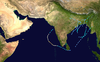
The 2005 North Indian Ocean cyclone season caused much devastation and many deaths in Southern India despite the storms’ weakness. The basin covers the Indian Ocean north of the equator as well as inland areas, sub-divided by the Arabian Sea and the Bay of Bengal. Although the season began early with two systems in January, the bulk of activity was confined from September to December. The official India Meteorological Department tracked 12 depressions in the basin, and the unofficial Joint Typhoon Warning Center (JTWC) monitored two additional storms. Three systems intensified into a cyclonic storm, which have sustained winds of at least 63 km/h (39 mph), at which point the IMD named them.
The 1992 North Indian Ocean cyclone season was unofficially the most active year on record for the basin, with 10 tropical storms developing, according to the Joint Typhoon Warning Center (JTWC). There are two main seas in the North Indian Ocean – the Bay of Bengal to the east of the Indian subcontinent – and the Arabian Sea to the west of India. The official Regional Specialized Meteorological Centre in this basin is the India Meteorological Department (IMD), while the JTWC releases unofficial advisories. An average of four to six storms form in the North Indian Ocean every season with peaks in May and November. Cyclones occurring between the meridians 45°E and 100°E are included in the season by the IMD.
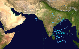
The 2008 North Indian cyclone season was one of the most disastrous tropical cyclone seasons in modern history, causing more than 140,000 fatalities and over US$15 billion in damage. At the time, it was the costliest season in the North Indian Ocean, until it was surpassed by 2020. The season has no official bounds but cyclones tend to form between April and December. These dates conventionally delimit the period of each year when most tropical cyclones form in the northern Indian Ocean. There are two main seas in the North Indian Ocean—the Bay of Bengal, which is east of India, and the Arabian Sea, which is west of India. The official Regional Specialized Meteorological Centre in this basin is the India Meteorological Department (IMD), however the Joint Typhoon Warning Center releases unofficial advisories for military interests. An average of four to six storms form in the North Indian Ocean every season. Cyclones occurring between the meridians 45°E and 100°E are included in the season by the IMD.
The 2000 North Indian Ocean cyclone season was fairly quiet compared to the year before, 1999 North Indian Ocean cyclone season, with all of the activity originating in the Bay of Bengal. The basin comprises the Indian Ocean north of the equator, with warnings issued by the India Meteorological Department (IMD) in New Delhi. There were six depressions throughout the year, of which five intensified into cyclonic storms – tropical cyclones with winds of 65 mph (105 km/h) sustained over 3 minutes. Two of the storms strengthened into a Very Severe Cyclonic Storm, which has winds of at least 120 km/h (75 mph), equivalent to a minimal hurricane. The Joint Typhoon Warning Center (JTWC) also tracked storms in the basin on an unofficial basis, estimating winds sustained over 1 minute.
The 2009 North Indian Ocean cyclone season was an event in the annual cycle of tropical cyclone formation. The North Indian Ocean cyclone season has no official bounds, but cyclones tend to form between April and December, with peaks in May and November. These dates conventionally delimit the period of each year when most tropical cyclones form in the northern Indian Ocean.
Cyclonic Storm Nisha was a fairly weak but catastrophic tropical cyclone that struck Sri Lanka, and India which killed over 200. It was the ninth tropical cyclone of the 2008 North Indian Ocean cyclone season, and the seventh tropical cyclone in the Bay of Bengal that year.
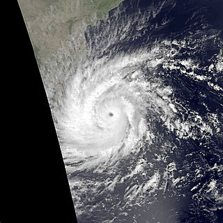
Severe Cyclonic Storm Laila was the first cyclonic storm to affect southeastern India in May since the 1990 Andhra Pradesh cyclone. The first tropical cyclone of the annual season, Laila developed on May 17, 2010 in the Bay of Bengal from a persistent area of convection. Strengthening as it tracked northwestward, it became a severe cyclonic storm on May 19. The next day, Laila made landfall in Andhra Pradesh, and it later dissipated over land. It caused flooding and damage along its path. Laila is an Urdu/Arabic name, meaning Night. It was the worst storm to hit Andhra Pradesh in the last 14 years.
The 2012 North Indian Ocean cyclone season was a very inactive season. The season had a very late start, with the first system forming in October. During the season, only five systems formed, of which only two became cyclonic storms. Both the storms made landfall, and they, along with the deep depressions, were responsible for 128 deaths and economic losses worth at least $56.7 million.
Very Severe Cyclonic Storm Thane was the strongest tropical cyclone of 2011 within the Bay of Bengal. Thane initially developed as a tropical disturbance within the monsoon trough to the west of Indonesia. Over the next couple of days the disturbance gradually developed further while moving towards the northwest, and was declared a Depression during December 25, before being named Cyclonic Storm Thane the next day. Thane started to turn towards the west under the influence of a subtropical ridge of high pressure before its development slowed during December 27, as a strong outflow and marginally favourable sea surface temperatures fought with persistent vertical wind shear. After its development had slowed during December 27, Thane became a Very Severe Cyclonic Storm during December 28, before as it approached the Indian states of Tamil Nadu, it weakened slightly. Thane then made landfall early on December 30, on the north Tamil Nadu coast between Cuddalore and Puducherry and rapidly weakened into a depression.
The 2013 North Indian Ocean cyclone season was an event in the annual cycle of tropical cyclone formation, in which tropical cyclones formed in the North Indian Ocean and Arabian Sea. The season had no official bounds, but cyclones typically formed between May and December, with the peak from October to November. These dates conventionally delimit the period of each year when most tropical cyclones form in the northern Indian Ocean.
Cyclonic Storm Nilam was the deadliest tropical cyclone to directly affect South India since Cyclone Jal in 2010. Originating from an area of low pressure over the Bay of Bengal on October 28, 2012, the system began as a weak depression 550 km (340 mi) northeast of Trincomalee, Sri Lanka. Over the following few days, the depression gradually intensified into a deep depression, and subsequently a cyclonic storm by October 30. It made landfall near Mahabalipuram on October 31 as a strong cyclonic storm with peak winds of 85 km/h (55 mph). In Chennai's Marina Beach, strong winds pushed piles of sand ashore and seawater reached nearly a 100 m (330 ft) inland. Schools and colleges in the city remained closed for more than three days.
The 1978 Sri Lanka Cyclone was one of the most destructive tropical cyclones to strike Sri Lanka since modern records began. The cyclone formed on November 17, 1978, and attained peak intensity on November 23, 1978, right before making landfall in Batticaloa. Sri Lanka's eastern province was heavily affected by the cyclone.
The 2016 North Indian Ocean cyclone season was an event in the annual cycle of tropical cyclone formation. It was the deadliest season since 2010, killing more than 400 people. The season was an average one, seeing four named storms, with one further intensifying into a very severe cyclonic storm. The first named storm, Roanu, developed on 19 May while the season's last named storm, Vardah, dissipated on 18 December. The North Indian Ocean cyclone season has no official bounds, but cyclones tend to form between April and December, with the two peaks in May and November. These dates conventionally delimit the period of each year when most tropical cyclones form in the northern Indian Ocean.
The 2017 North Indian Ocean cyclone season was a below average yet deadly season in the annual cycle of tropical cyclone formation. This season produced only three named storms, of which one only intensified into a very severe cyclonic storm. The North Indian Ocean cyclone season has no official bounds but cyclones tend to form between April and December with the two peaks in May and November. These dates conventionally delimit the period of each year when most tropical cyclones form in the northern Indian Ocean. The season began with the formation Cyclone Maarutha on April 15 and ended with the dissipation of a deep depression on December 9.
The 2018 North Indian Ocean cyclone season was one of the most active North Indian Ocean cyclone seasons since 1992, with the formation of fourteen depressions and seven cyclones. The North Indian Ocean cyclone season has no official bounds, but cyclones tend to form between April and December, with the two peaks in May and November. These dates conventionally delimit the period of each year when most tropical cyclones form in the northern Indian Ocean.
The 2020 North Indian Ocean cyclone season was the costliest North Indian Ocean cyclone season on record, mostly due to the devastating Cyclone Amphan. The North Indian Ocean cyclone season has no official bounds, but cyclones tend to form between April and November, with peaks in late April to May and October to November. These dates conventionally delimit the period of each year when most tropical cyclones form in the northern Indian Ocean. The season began on May 16 with the designation of Depression BOB 01 in the Bay of Bengal, which later became Amphan. Cyclone Amphan was the strongest storm in the Bay of Bengal in 21 years and would break Nargis of 2008's record as the costliest storm in the North Indian Ocean. The season concluded with the dissipation of Cyclone Burevi on December 5. Overall, the season was slightly above average, seeing the development of five cyclonic storms.
The 2021 North Indian Ocean cyclone season was an average season, the North Indian Ocean cyclone season has no official bounds, but cyclones tend to form between April and December, peaking between May and November. These dates conventionally delimit the period of each year when most tropical cyclones form in the northern Indian Ocean. The season began on April 2, when a depression designated as BOB 01 was formed in the north Andaman Sea and quickly made landfall in Myanmar. The basin remained quiet for over a month before Cyclone Tauktae formed. It rapidly intensified into an extremely severe cyclonic storm before making landfall in Gujarat, become the strongest storm ever to strike that state since the 1998 Gujarat cyclone. Later that month, BOB 02 formed and later strengthened into Cyclone Yaas. Yaas rapidly intensified into a very severe cyclonic storm before making landfall in northwestern Odisha. The season's strongest tropical cyclone was Cyclone Tauktae, with maximum wind speeds of 185 km/h (115 mph) and a minimum barometric pressure of 950 hPa (28.05 inHg).
Cyclonic Storm Burevi was a weak tropical cyclone which made landfall in Sri Lanka, becoming the first to do so since a depression in 2014, and brought minimal impact to Southern India in December 2020. The ninth depression and fifth named storm of the 2020 North Indian Ocean cyclone season, Burevi originated from a low-pressure area which formed on November 28. The system gradually became a depression on November 30, with the JTWC issuing a TCFA soon after. The depression then was upgraded into Cyclone Burevi the following day. Burevi slowly intensified reaching its peak intensity on December 2, just before making landfall in Sri Lanka. Burevi then weakened, entering the Gulf of Mannar the next day. Burevi proceeded to dissipate after stalling on December 5.
The 2021 South India floods are a series of floods associated with Depression BOB 05 and a low pressure system that caused widespread disruption across the Indian states of Tamil Nadu, Andhra Pradesh, and the nearby Sri Lanka. The rainfall started on 1 November in Tamil Nadu. The flooding was caused by extremely heavy downpours from BOB 05, killing at least 41 people across India and Sri Lanka.
Severe Cyclonic Storm Mandous was the third cyclonic storm, as well as the third most intense tropical cyclone of the 2022 North Indian Ocean cyclone season. The remnants of the system later regenerated into Deep Depression ARB 03 in the Arabian Sea. The system struck the Andaman and Nicobar Islands, as well as South India.
{{cite news}}
: |last=
has generic name (help)