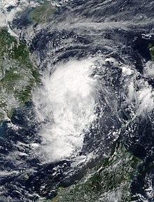
Tropical Storm Kirogi (2017)

Last updated
Map key
  Tropical depression (≤38 mph, ≤62 km/h)
  Tropical storm (39–73 mph, 63–118 km/h)
  Category 1 (74–95 mph, 119–153 km/h)
  Category 2 (96–110 mph, 154–177 km/h)
  Category 3 (111–129 mph, 178–208 km/h)
  Category 4 (130–156 mph, 209–251 km/h)
  Category 5 (≥157 mph, ≥252 km/h)
  Unknown
Storm type
Disc Plain black.svg Tropical cyclone
Solid black.svg Subtropical cyclone
ArrowUp.svg Extratropical cyclone, remnant low, tropical disturbance, or monsoon depression

On November 15 at 15:00 Coordinated Universal Time (UTC), the Joint Typhoon Warning Center (JTWC) began monitoring an area of convection approximately 355 nautical miles (655 km; 410 mi) east-southeast of Mindanao for potential development, estimating its development chances within the next day as low. The system was disorganized, with an exposed and ill-defined low-level circulation. [2] The system moved over more favorable conditions for development as the low-level circulation began to consolidate, and at 20:00 UTC, the JTWC upgraded the system's development chances within the next day to medium. [3] On November 16 at 12:00 UTC, the Japan Meteorological Agency (JMA) assessed that a tropical depression had formed over the Moro Gulf, [4] and at 21:00 UTC, the JTWC issued a Tropical Cyclone Formation Alert for the system. [5] On November 17 at 02:00 UTC, the PAGASA assessed that the system developed into a tropical depression, assigning it the local name Tino. [6] Four hours later at 06:00 UTC, the JTWC assessed that Tino had developed into a tropical depression, assigning it the designation 31W. [7] At 09:00 UTC, Tino made landfall on Puerto Princesa [6] before entering into the South China Sea. Tino entered the South China Sea as a disorganized system, with a weak low-level circulation and shallow convective bands. Conditions in the area were relatively favorable, with sea surface temperatures of 30 °C (86 °F), favorable outflow, and vertical wind shear at 15–20 knots (30–35 km/h; 15–25 mph) which was partially negated by the system's motion; development was partly limited due to northeasterly dry air. [8]

The JTWC upgraded Tino to a tropical storm at 18:00 UTC [7] as the system's low-level circulation became partially exposed; [9] the JMA followed on November 18 at 00:00 UTC, assigning it the international name Kirogi. The JMA estimated that Kirogi peaked in intensity at the same time, with maximum sustained winds of 65 km/h (40 mph) and a minimum central pressure of 1000  hPa (mbar; 29.53  inHg). [4] At 02:00 UTC, Kirogi left the Philippine Area of Responsibility [6] as its convection became displaced towards the west and northwest. [10] At 18:00 UTC, the JTWC estimated maximum 1-minute sustained winds of 75 km/h (45 mph); [7] convection began to fragment and collapse during the surrounding hours as an anticyclone continued to displace the convection, hindering the system's development. [11] [12] On November 19 at 00:00 UTC, the JMA downgraded Kirogi to a tropical depression, [4] before making landfall south-southwest of Cam Ranh Bay [13] and being downgraded to a tropical depression by the JTWC at 06:00 UTC. [7] Kirogi was downgraded to a disturbance by the JTWC at 12:00 UTC, [7] with the JMA estimating the system to have dissipated. [4] Kirogi's remnants would later move into the Gulf of Thailand on November 20 [14] and into the Andaman Sea on November 21, [15] later contributing to the formation of Cyclone Ockhi. [16]

Preparations and impact

Philippines

Signal #1 warnings were raised for the province of Palawan by the PAGASA on November 17 at 03:00 UTC. [17] Warnings remained for Palawan until later that day at 15:00 UTC. [18] The PAGASA advised against sea travel due to rough seas, also warning residents of the possibility of landslides and flooding. [19] In Davao City, several families evacuated due to flooding. [6] Over 200 people in Taytay, Palawan, San Vicente, Palawan, and Roxas, Palawan were evacuated. On November 17, Culion and Puerto Princesa suspended classes for the day. [20] Almost 100 people were evacuated in Mansalay, Oriental Mindoro. Bad weather prompted the cancellation of five domestic flights. [21]

Several barangays in Mansalay were affected by floodwaters 0.5–1 meter (1.6–3.3 ft) deep; San Vicente received floods 1 metre (3.3 ft) deep. Three houses were damaged in Palawan; ports in Puerto Princesa, Coron, Palawan, Cuyo, Palawan, El Nido, Palawan, and Brooke's Point temporarily suspended operations, stranding 243 passengers. A total of 497 people were affected as a result of the storm. [6]

Vietnam

The National Center for Hydro-Meteorological Forecasting issued emergency warnings for Bình Thuận Province, Khánh Hòa Province, and Ninh Thuận Province from November 18–19. [1] Ninh Thuận ordered fishing boats to anchor in storm shelters before the end of November 18. By the next day, more than 2,600 boats entered storm shelters, with 535 others at sea also having been reported to have sought shelter. Five households in Thuận Bắc District were evacuated; residents and tourists were advised and warned to move away from areas close to the shore. [22] Flood warnings were issued for rivers in Bình Thuận, Central Highlands, Đồng Nai Province, and Hà Tĩnh Province from November 19–24. People living in vulnerable areas were evacuated, with local authorities making plans for reinforcing structures and further evacuations. [23]

Trees in Ho Chi Minh City were uprooted due to strong winds, with several streets experiencing 300 millimetres (12 in) of flooding. [24] Roofs were also blown off of houses in the city, with fallen power poles causing power outages. Flooding on National Route 50  [ vi ] reached depths of 1 metre (3.3 ft). [25] 8,289 buildings were flooded, of which 7,966 were in Thừa Thiên Huế Province and 323 were in Quảng Trị Province. Several hundred meters of embankments for the Hiếu River were damaged by flooding in Cam Lộ. Water was released from reservoirs in Central Vietnam and the Central Highlands due to high water levels. In Mỹ Chánh, Quảng Trị, a reported 300 millimetres (12 in) of rain fell within 24 hours. [26] 182 millimetres (7.2 in) of rain was reported in Qui Nhơn, with Huế reporting 142 millimetres (5.6 in) of rain. [27] 517 hectares (1,280 acres) of rice and 60 hectares (150 acres) of other crops were damaged. Eight fatalities were reported by the Vietnam Disaster Management Authority  [ vi ]. [28]

Elsewhere

On November 19 in Ko Kut, 82.4 millimetres (3.24 in) of rainfall was recorded in 24 hours. [29] The Thai Meteorological Department advised residents of the possibility of flash floods, strong winds, and storm surge, also cautioning ships of waves forecasted to reach 2 meters (6.6 ft). [30]

See also

Related Research Articles

<span class="mw-page-title-main">2013 Pacific typhoon season</span> Typhoon season in the Western Pacific Ocean

The 2013 Pacific typhoon season was the most active Pacific typhoon season since 2004, and the deadliest since 1975. It featured Typhoon Haiyan, one of the most powerful storms and one of the strongest landfalling tropical cyclones in history. It was an above-average season with 31 named storms, 13 typhoons, and five super typhoons. The season's first named storm, Sonamu, developed on January 4 while the season's last named storm, Podul, dissipated on November 15. Despite the activity, most of the first seventeen named storms before mid-September were relatively weak, as only two of them reached typhoon intensity. Total damage amounted to at least $26.41 billion (USD), making it at the time the costliest Pacific typhoon season on record; it is currently the third costliest, behind the 2018 and 2019 seasons.

<span class="mw-page-title-main">2017 Pacific typhoon season</span> Typhoon season in the Western Pacific Ocean

The 2017 Pacific typhoon season was a below-average season in terms of accumulated cyclone energy and the number of typhoons and super typhoons, and the first since the 1977 season to not produce a Category 5-equivalent typhoon on the Saffir–Simpson scale. The season produced a total of 27 named storms, 11 typhoons, and only two super typhoons, making it an average season in terms of storm numbers. It was an event in the annual cycle of tropical cyclone formation, in which tropical cyclones form in the western Pacific Ocean. The season runs throughout 2017, though most tropical cyclones typically develop between May and October. The season's first named storm, Muifa, developed on April 25, while the season's last named storm, Tembin, dissipated on December 26. This season also featured the latest occurrence of the first typhoon of the year since 1998, with Noru reaching this intensity on July 23.

<span class="mw-page-title-main">2018 Pacific typhoon season</span> Typhoon season in the Western Pacific Ocean

The 2018 Pacific typhoon season was at the time, the costliest Pacific typhoon season on record, until the record was beaten by the following year. The season was well above-average, producing twenty-nine storms, thirteen typhoons, seven super typhoons and six Category 5 tropical cyclones. The season ran throughout 2018, though most tropical cyclones typically develop between May and October. The season's first named storm, Bolaven, developed on January 3, while the season's last named storm, Man-yi, dissipated on November 28. The season's first typhoon, Jelawat, reached typhoon status on March 29, and became the first super typhoon of the year on the next day.

<span class="mw-page-title-main">Timeline of the 2013 Pacific typhoon season</span>

Most of the tropical cyclones of the 2013 Pacific typhoon season formed between May and November of that year. The scope of this article is the Pacific Ocean north of the equator, between 100°E and the International Date Line. Tropical storms which form in the Western Pacific basin are assigned a name by the Japan Meteorological Agency (JMA). Tropical depressions forming in this basin are given a number with a "W" suffix by the United States' Joint Typhoon Warning Center (JTWC). The Philippine Atmospheric, Geophysical and Astronomical Services Administration (PAGASA) assigns names to tropical cyclones that enter or form in the Philippine area of responsibility, but these names are not in common use outside the Philippines.

<span class="mw-page-title-main">Meteorological history of Typhoon Haiyan</span>

Typhoon Haiyan's meteorological history began with its origins as a tropical disturbance east-southeast of Pohnpei and lasted until its degeneration as a tropical cyclone over southern China. The thirteenth typhoon of the 2013 Pacific typhoon season, Haiyan originated from an area of low pressure several hundred kilometers east-southeast of Pohnpei in the Federated States of Micronesia on November 2. Tracking generally westward, environmental conditions favored tropical cyclogenesis and the system developed into a tropical depression the following day. After becoming a tropical storm and attaining the name Haiyan at 0000 UTC on November 4, the system began a period of rapid intensification that brought it to typhoon intensity by 1800 UTC on November 5. By November 6, the Joint Typhoon Warning Center (JTWC) assessed the system as a Category 5-equivalent super typhoon on the Saffir–Simpson hurricane wind scale; the storm passed over the island of Kayangel in Palau shortly after attaining this strength.

<span class="mw-page-title-main">Timeline of the 2014 Pacific typhoon season</span>

This timeline documents all of the events of the 2014 Pacific typhoon season. Most of the tropical cyclones forming between May and November. The scope of this article is limited to the Pacific Ocean, north of the equator between 100°E and the International Date Line. Tropical storms that form in the entire Western Pacific basin are assigned a name by the Japan Meteorological Agency. Tropical depressions that form in this basin are given a number with a "W" suffix by the United States' Joint Typhoon Warning Center. In addition, the Philippine Atmospheric, Geophysical and Astronomical Services Administration (PAGASA) assigns names to tropical cyclones that enter or form in the Philippine area of responsibility. These names, however, are not in common use outside of the Philippines.

<span class="mw-page-title-main">Tropical Storm Lingling (2014)</span> Pacific tropical storm in 2014

Tropical Storm Lingling, known in the Philippines as Tropical Depression Agaton, was a weak but deadly tropical cyclone that affected the Philippines in January 2014. The first named storm of the annual typhoon season, this early-season cyclone remained very disorganized throughout its lifespan. Lingling was the first major natural disaster in the Philippines after Typhoon Haiyan just two months earlier, as it caused widespread landslide incidents and floods in Mindanao, resulting in 70 deaths and damage amounting to over 566 million pesos on the island.

<span class="mw-page-title-main">Timeline of the 2012 Pacific typhoon season</span>

This timeline documents all of the events of the 2012 Pacific typhoon season. The scope of this article is limited to the Pacific Ocean, north of the equator between 100°E and the International Date Line. During the season, 34 systems were designated as tropical depressions by either the Japan Meteorological Agency (JMA), the Philippine Atmospheric, Geophysical and Astronomical Services Administration (PAGASA), the Joint Typhoon Warning Center (JTWC), or other National Meteorological and Hydrological Services such as the China Meteorological Administration and the Hong Kong Observatory. Since the JMA runs the Regional Specialized Meteorological Centre (RSMC) for the Western Pacific, they assigned names to tropical depressions which developed into tropical storms in the basin. PAGASA also assigned local names to systems which are active in their area of responsibility; however, these names are not in common use outside of the Philippines.

<span class="mw-page-title-main">Tropical Storm Tess</span> Pacific severe tropical storm in 1988

Severe Tropical Storm Tess known in the Philippines as Tropical Storm Welpring was the second of three tropical cyclones to directly impact the Philippines in a two-week time frame in 1988. An area of disturbed weather near the Philippines was first observed on November 1. Following an increase in organization, the disturbance was designated as a tropical cyclone on November 4. Moving west, Tess steadily strengthened due to favorable conditions aloft. During the evening of November 5, Tess was estimated to have achieved its highest intensity, with winds of 115 km/h (70 mph). Rapid weakening then ensured as Tess neared Vietnam, and after making landfall in the country on November 6, Tess dissipated the next day.

<span class="mw-page-title-main">Tropical Storm Kujira (2015)</span> 2015 Pacific tropical storm

Tropical Storm Kujira was a tropical cyclone that prompted the PAGASA to declare the beginning of the rainy season in the Philippines. The ninth tropical depression, 8th named storm, and first storm to make landfall on China in the 2015 Pacific typhoon season, it formed as a tropical depression south of the Paracel Islands on June 19.

<span class="mw-page-title-main">Typhoon Tembin</span> Pacific typhoon in 2017

Typhoon Tembin, known in the Philippines as Typhoon Vinta, was the deadliest tropical cyclone to strike Mindanao since Typhoon Bopha in 2012. Following and impacting the Philippines less than a few days after the deadly Tropical Storm Kai-tak, Tembin, which means Libra in Japanese, the twenty-seventh named storm and the eleventh typhoon of the 2017 Pacific typhoon season. It was first classified as a weak tropical depression on December 16. The system gradually intensified and consolidated into a tropical storm on December 20. Tembin made landfall in Mindanao late the next day. On December 23, Tembin followed a path towards the South China Sea and intensified into a typhoon early the following day. Quick intensification ensued and Tembin reached its peak intensity as a low-end Category 2 typhoon as assessed by the Joint Typhoon Warning Center on December 24. Unfavorable conditions enhanced by the winter monsoon caused Tembin to rapidly weaken shortly afterwards, before it ultimately dissipated on December 26 while just south of Vietnam.

<span class="mw-page-title-main">2021 Pacific typhoon season</span> Typhoon season in the Western Pacific Ocean

The 2021 Pacific typhoon season was the second consecutive to have below-average tropical cyclone activity, with twenty-two named storms, and was the least active since 2011. Nine became typhoons, and five of those intensified into super typhoons. This low activity was caused by a strong La Niña that had persisted from the previous year. The season's first named storm, Dujuan, developed on February 16, while the last named storm, Rai, dissipated on December 21. The season's first typhoon, Surigae, reached typhoon status on April 16. It became the first super typhoon of the year on the next day, also becoming the strongest tropical cyclone in 2021. Surigae was also the most powerful tropical cyclone on record in the Northern Hemisphere for the month of April. Typhoons In-fa and Rai are responsible for more than half of the total damage this season, adding up to a combined total of $2.02 billion.

<span class="mw-page-title-main">2022 Pacific typhoon season</span> Typhoon season in the Western Pacific Ocean

The 2022 Pacific typhoon season was the third consecutive season to have below-average tropical cyclone activity, with twenty-five named storms forming. Of the tropical storms, ten became typhoons, and three would intensify into super typhoons. The season saw a slightly below average activity by named storm count, although many of the storms were weak and short-lived, particularly towards the end of the season. This low activity was caused by an unusually strong La Niña that had persisted from 2020. The season's first named storm, Malakas, developed on April 6, while the last named storm, Pakhar, dissipated on December 12. The season's first typhoon, Malakas, reached typhoon status on April 12. The season ran throughout 2022, though most tropical cyclones typically develop between May and October. Tropical storms Megi and Nalgae were responsible for more than half of the casualties, while typhoons Hinnamnor and Nanmadol both caused $1 billion in damages.

<span class="mw-page-title-main">Tropical Storm Sanba (2018)</span> Pacific tropical storm in 2018

Tropical Storm Sanba, known in the Philippines as Tropical Storm Basyang, was a weak tropical cyclone that affected southern and central parts of the Philippines in mid-February 2018. Sanba developed as a tropical depression in the open Pacific Ocean on February 8. The system moved generally westward while slowly developing, finally attaining tropical storm status on February 11. Soon after, wind shear caused the system to lose organization and remain as a minimal tropical storm through February 11 and 12. During this time, Sanba moved westwards then west-northwestwards, making landfall over northeastern Mindanao on February 13. The system weakened into a tropical depression before making another landfall in southeastern Negros later that day. After traversing the Philippine Islands, Sanba failed to reorganize significantly in the Sulu Sea and dissipated two days later west of Palawan.

<span class="mw-page-title-main">Tropical Storm Toraji (2018)</span> Pacific tropical storm in 2018

Tropical Storm Toraji was a weak, short-lived system that impacted Vietnam in November 2018. Forming as the twenty-seventh named storm of the 2018 Pacific typhoon season, Toraji developed as a tropical depression to the southeast of Vietnam on November 16. Quickly organising, the system strengthened into a tropical storm the next day. Toraji rapidly weakened thereafter early on November 18, when the storm made landfall over southeastern Vietnam, later dissipating. The storm's remnants moved into the Gulf of Thailand when Toraji re-organised back into a tropical depression on November 20. However Toraji quickly deteriorated on the same day as it moved closer to the Malay Peninsula.

<span class="mw-page-title-main">Typhoon Soulik (2018)</span> Pacific typhoon in 2018

Typhoon Soulik was an unusually large, and the deadliest typhoon to strike the Korean Peninsula since Khanun in 2012. Soulik formed from an area of low pressure on August 15, and was the twenty-ninth tropical depression, twentieth tropical storm, tenth severe tropical storm, and sixth typhoon of the 2018 Pacific typhoon season.

<span class="mw-page-title-main">Tropical Storm Usagi (2018)</span> Western Pacific severe tropical storm in 2018

Severe Tropical Storm Usagi, known in the Philippines as Tropical Storm Samuel, was a tropical cyclone that affected the Philippines and Southern Vietnam in late November 2018, causing severe damage around the Visayas region and Ho Chi Minh City. The storm formed from a disturbance in the Central Pacific basin on November 3, but did not develop into a tropical storm until almost three weeks later, on November 13. Usagi underwent rapid intensification and peaked in intensity before making its final landfall on Vũng Tàu, Bà Rịa–Vũng Tàu province as a weakening tropical storm on November 25. While never considered as a typhoon by the Japan Meteorological Agency (JMA), the Joint Typhoon Warning Center (JTWC) assessed its intensity to be equivalent to Category 2 status on the Saffir–Simpson scale. Usagi caused one death and ₱52.2 million (US$992,000) in damages in the Philippines, most of which came from agriculture. Usagi caused 3 deaths and ₫925 billion in damages in Vietnam.

<span class="mw-page-title-main">Tropical Storm Dawn (1998)</span> 1998 tropical cyclone

Tropical Storm Dawn was a weak tropical cyclone that caused 187 deaths in Vietnam, and was described as the worst storm to hit the region in 3 decades. The 27th tropical depression and 13th named storm of the 1998 Pacific typhoon season, Dawn formed from a monsoon trough in the South China Sea on November 16. The same day at 18:00 UTC, the Japan Meteorological Agency (JMA) assessed that it had become a tropical depression. The depression continued organizing, and on November 18 at 18:00 UTC, the Joint Typhoon Warning Center (JTWC) upgraded the depression to a tropical storm, giving it the name Dawn. Dawn peaked 1-minute sustained winds of 45 knots before making landfall near Cam Ranh, moving inland and quickly dissipating.

<span class="mw-page-title-main">Tropical Storm Maliksi (2018)</span> West Pacific Tropical storm in 2018

Severe Tropical Storm Maliksi, known in the Philippines as Severe Tropical Storm Domeng, was a tropical cyclone in June 2018 that brought rainfall to the Philippines and Japan. It caused 2 deaths and prompted the PAGASA to declare the beginning of the rainy season in the Philippines. The fifth named storm and 4th tropical cyclone in the Philippine Area of Responsibility (PAR), it was first noted as an area of convection in the South of Palau on May 31.

<span class="mw-page-title-main">Tropical depressions Wilma and BOB 05</span> A series of tropical cyclones in 2013

Tropical Depression Wilma, also referred to as 30W and Depression BOB 05 were a series of tropical cyclones that traveled from the Northwest Pacific Ocean to the North Indian Ocean in 2013. Forming east of Palau on November 1, the tropical depression passed through the Philippines on November 4 and emerged into the South China Sea on the next day. Without intensification, the system made landfall over Vietnam on November 6 and arrived at the Gulf of Thailand on November 7.

References

  1. 1 2 "Situation Update No. 6 Final for Typhoon Damrey, Viet Nam" (PDF). ASEAN Coordinating Centre for Humanitarian Assistance. November 18, 2017. p. 2. Retrieved June 12, 2021.
  2. "Significant Tropical Weather Advisory for the Western and South Pacific Oceans Reissued from 151500Z–160600Z November 2017". Joint Typhoon Warning Center . November 15, 2017. Archived from the original on July 30, 2017. Retrieved June 9, 2021 via National Oceanic and Atmospheric Administration.
  3. "Significant Tropical Weather Advisory for the Western and South Pacific Oceans Reissued from 152000Z–160600Z November 2017". Joint Typhoon Warning Center . November 15, 2017. Archived from the original on July 30, 2017. Retrieved June 9, 2021 via National Oceanic and Atmospheric Administration.
  4. 1 2 3 4 Annual Report on the Activities of the RSMC Tokyo - Typhoon Center 2017 (PDF) (Report). Japan Meteorological Agency. December 27, 2018. pp. 43, 102. Retrieved June 10, 2021.
  5. "WTPN21 PGTW 162100". Joint Typhoon Warning Center . November 16, 2017. Archived from the original on August 5, 2017. Retrieved June 10, 2021 via National Oceanic and Atmospheric Administration.
  6. 1 2 3 4 5 SitRep No. 03 re Preparedness Measures and Effects of Tropical Storm "Tino" (PDF) (Report). National Disaster Risk Reduction and Management Council. November 19, 2017. Retrieved June 10, 2021.
  7. 1 2 3 4 5 Chu, J H.; Levine, A.; Daida, S.; et al. "2017 Western North Pacific Ocean Best Track Data". Joint Typhoon Warning Center . Retrieved June 10, 2021.
  8. "Prognostic Reasoning for Tropical Depression 31W (Thirtyone) Warning NR 01". Joint Typhoon Warning Center . November 17, 2017. Archived from the original on July 29, 2018. Retrieved June 10, 2021 via National Oceanic and Atmospheric Administration.
  9. "Prognostic Reasoning for Tropical Storm 31W (Thirtyone) Warning NR 02". Joint Typhoon Warning Center . November 17, 2017. Archived from the original on August 4, 2017. Retrieved June 10, 2021 via National Oceanic and Atmospheric Administration.
  10. "Prognostic Reasoning for Tropical Storm 31W (Kirogi) Warning NR 04". Joint Typhoon Warning Center . November 18, 2017. Archived from the original on August 4, 2017. Retrieved June 10, 2021 via National Oceanic and Atmospheric Administration.
  11. "Prognostic Reasoning for Tropical Storm 31W (Kirogi) Warning NR 05". Joint Typhoon Warning Center . November 18, 2017. Archived from the original on August 4, 2017. Retrieved June 10, 2021 via National Oceanic and Atmospheric Administration.
  12. "Prognostic Reasoning for Tropical Storm 31W (Kirogi) Warning NR 06". Joint Typhoon Warning Center . November 18, 2017. Archived from the original on August 4, 2017. Retrieved June 10, 2021 via National Oceanic and Atmospheric Administration.
  13. Gutro, Rob (November 18, 2017). "NASA Spots Tropical Depression Kirogi Dissipating". NASA . Retrieved June 10, 2021.
  14. Sakudomchai, Wanchai (November 20, 2017). "Weather Warning "Tropical Depression 'Kirogi' " No. 12". Thai Meteorological Department . Retrieved June 12, 2021.
  15. Kurian, Vinson (November 21, 2017). "N-E monsoon may revive next week, last into mid-December". Business Line . Retrieved June 11, 2021.
  16. Very Severe Cyclonic Storm "Ockhi" over Bay of Bengal (29 November–06 December 2017): A Report (PDF) (Report). India Meteorological Department. p. 1. Archived from the original (PDF) on September 30, 2020. Retrieved June 11, 2021.
  17. "Low pressure area now Tropical Depression Tino". Rappler . November 17, 2017. Retrieved June 11, 2021.
  18. "Tropical Depression Tino begins to move away from PH". Rappler . November 17, 2017. Retrieved June 11, 2021.
  19. "'Tino' makes landfall over Palawan". ABS-CBN News and Current Affairs . November 17, 2017. Retrieved June 11, 2021.
  20. "#TinoPH leaves country as intensified tropical storm". CNN Philippines . November 18, 2017. Archived from the original on June 5, 2018. Retrieved June 11, 2021.
  21. "#TinoPH brings rains ahead of Palawan landfall". CNN Philippines . November 17, 2017. Archived from the original on November 20, 2017. Retrieved June 11, 2021.
  22. "AHA Centre Flash Update #2 for Tropical Storm Kirogi (31)". ASEAN Coordinating Centre for Humanitarian Assistance. November 19, 2017. Retrieved June 12, 2021 via ReliefWeb.
  23. "AHA Centre Flash Update #1 for Tropical Storm Kirogi (31)". ASEAN Coordinating Centre for Humanitarian Assistance. November 18, 2017. Retrieved June 12, 2021 via ReliefWeb.
  24. An, Xuan (November 18, 2018). "Heavy rain floods Saigon as Storm Kirogi approaches south-central Vietnam". VnExpress . Retrieved July 19, 2021.
  25. "Downpour inundates streets, unroofs houses in Ho Chi Minh City". Tuổi Trẻ . November 19, 2017. Retrieved July 19, 2021.
  26. Davies, Richard (November 22, 2017). "Vietnam – 2 Dead, 1 Missing After Floods in Central Areas". FloodList. Retrieved June 12, 2021.
  27. "Tropical Storm Kirogi hits Vietnam". Al Jazeera . November 20, 2017. Retrieved June 12, 2021.
  28. Phụ Lục Tổng Hợp Thiệt Hại Do Thiên Tai Năm 2017 (PDF) (Report) (in Vietnamese). Vietnam Disaster Management Authority. p. 1. Retrieved January 16, 2022.
  29. "Monthly Weather Summary in Thailand November 2017" (PDF). Thai Meteorological Department . p. 2. Retrieved June 12, 2021.
  30. Sakudomchai, Wanchai (November 20, 2017). "Weather Warning "Tropical Depression 'Kirogi' " No. 11". Thai Meteorological Department . Retrieved June 12, 2021.
Tropical Storm Kirogi (Tino)
Kirogi 2017-11-18 0300Z.jpg
Kirogi at peak intensity on November 18