
Karimnagar is also known as Elagandula is a city and District Headquarters in the Indian state of Telangana. Karimnagar is a major urban agglomeration and fifth largest City in the state. It is governed by Municipal corporation and is the headquarters of the Karimnagar district It is situated on the banks of Manair River, which is a tributary of the Godavari River.It is the third largest and fastest growing urban settlement in the state, according to 2011 census. It has registered a population growth rate of 45.46% and 38.87% respectively over the past two decades between 1991 and 2011, which is highest growth rate among major cities of Telangana. It serves as a major educational and health hub for the northern districts of Telangana. It is a major business center and widely known for its agricultural and granite industries, earning the nickname "City of Granites."

Anantapur, officially Anantapuramu, is a city in Anantapur district of the Indian state of Andhra Pradesh. It is the mandal headquarters of Anantapuru mandal and also the divisional headquarters of Anantapur revenue division. The city is located on National Highway. It was also the headquarters of the Datta Mandalam in 1799. It was also a position of strategic importance for the British Indian Army during the Second World War.

Bhadrachalam is a census town in Bhadradri Kothagudem district in the Indian state of Telangana. It is an important Hindu pilgrimage town with the Bhadrachalam Temple of Lord Rama, situated on the banks of Godavari river. It is located 312 kilometres (194 mi) east of state capital, Hyderabad,115 kilometres (71 mi) from Khammam,178 kilometres (111 mi) from Suryapet,180 kilometres (112 mi) from Warangal,187 kilometres (116 mi) from Vijayawada,220 kilometres (137 mi) and 350 kilometres (217 mi) from Visakhapatnam.

Miryalaguda is a city in Nalgonda district of the Indian state of Telangana. In 2015, the Government of India placed Miryalaguda under the Atal Mission for Rejuvenation and Urban Transformation scheme. It is located about 44 kilometres (27 mi) from the district headquarters Nalgonda, 142 kilometres (88 mi) from the state capital Hyderabad.

Telangana is a state in India situated on the south-central stretch of the Indian peninsula on the high Deccan Plateau. It is the eleventh-largest state and the twelfth-most populated state in India with a geographical area of 112,077 km2 (43,273 sq mi) and 35,193,978 residents as per 2011 census. On 2 June 2014, the area was separated from the northwestern part of Andhra Pradesh as the newly formed state of Telangana, with Hyderabad as its capital. Its other major cities include Warangal, Nizamabad, Khammam, Karimnagar and Ramagundam. Telangana is bordered by the states of Maharashtra to the north, Chhattisgarh to the northeast, Karnataka to the west, and Andhra Pradesh to the east and south. The terrain of Telangana consists mostly of the Deccan Plateau with dense forests covering an area of 27,292 km2 (10,538 sq mi). As of 2019, the state of Telangana is divided into 33 districts.

Rayalaseema is a geographic region in the Indian state of Andhra Pradesh. It comprises eight southwestern districts of the State, namely Kurnool, Nandyal, Anantapur, Sri Sathya Sai, YSR, Annamayya, Tirupati and Chittoor districts As of 2011 census of India, the region with four districts had a population of 15,184,908 and covers an area of 71,060 km2 (27,440 sq mi).

Rajahmundry, officially known as Rajamahendravaram, is a city in the Indian state of Andhra Pradesh and District headquarters of East Godavari district. It is the fifth most populated city in the state. During British rule, the District of Rajahmundry was created in the Madras Presidency in 1823. It was reorganised in 1859 and bifurcated into the Godavari and Krishna districts. Rajahmundry was the headquarters of Godavari district, which was further bifurcated into East Godavari and West Godavari districts in 1925. When the Godavari district was bifurcated, Kakinada became the headquarters of East Godavari and Eluru became the headquarters of West Godavari. It is administered under Rajahmundry revenue division of the East Godavari district. The city is known for its floriculture, history, culture, agriculture, economy, tourism, and its heritage. It is known as the "Cultural Capital of Andhra Pradesh".

Kurnool district is one of the eight districts in the Rayalaseema region of the Indian state of Andhra Pradesh. It is located in the North western part of the state and is bounded by Jogulamba Gadwal district of Telangana in the north, Raichur district of Karnataka in the northwest, Bellary district of Karnataka in the west, Anantapur district in the south and Nandyal district in the east. The city of Kurnool is the headquarters of the district. It has a population of 2,271,686 of which 28.35% were urban as of 2011.

Nalgonda district is a district in the Telangana state of India. Nalgonda district has the highest number of mandals in the state with 31 mandals. The district shares boundaries with Suryapet, Rangareddy, Yadadri and Nagarkurnool districts and with the state boundary of Andhra Pradesh.
Bhongir, officially known as, Bhuvanagiri is a City and a district headquarters of the Yadadri Bhuvanagiri district and part of the Hyderabad Metropolitan Region of the Indian state of Telangana. The famous family hotel is Sri Laxmi Narsimha Swamy Hotel.
Vadapally, or Wadapally, formerly known as Vazeerabad, is a village in Nalgonda district of Telangana, India, near Miryalaguda. Vadapally comes under the assembly constituency of Miryalaguda, 24 km (15 mi) from the village.
Vuyyuru is a town in Krishna district of the Indian state of Andhra Pradesh. It is a Nagar panchayat and the headquarters of Vuyyuru Mandal. It is emerging as neighbourhood of Vijayawada, India situated 30 km away.
Kondrapole is a village Damarchrla Mandal in Nalgonda district of the Indian state of Telangana.
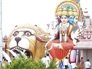
Sri Lakshmi Narasimha Swamy Temple or simply known as Yadadri or Yadagirigutta temple, is a Hindu temple situated on a hillock in the small town of Yadagirigutta in the Yadadri Bhuvanagiri district of the Indian state of Telangana. The temple is an abode of Narasimha, an incarnation of Lord Vishnu.

Gutha Sukender Reddy is an Indian BRS politician who is the 2nd and current Chairman of the Telangana Legislative Council since 14 March 2022. He was elected as MLC in 2019 & 2021 respectively.
Surendrapuri is a religious tourism destination located near Hyderabad, Telangana, India in the Yadadri Bhuvanagiri district. The 17-acre religious complex includes the Kunda Satyanarayana Kaladhamam - India's first mythological museum, Panchamukha Hanumadeeswara Devasthanam (Hindu temple), Navagraha temples, Nagakoti idol, and Surendrapuri’s iconic two-sided Panchamukha Hanuman-Shiva statue.

Suryapet district is a district in the Indian state of Telangana. The city of Suryapet is the district headquarters. The district has three revenue divisions Suryapet, Kodad and Huzurnagar. It is sub-divided into 23 mandals. The district shares boundaries with Nalgonda, Khammam, Yadadri, Jangaon and Mahabubabad districts and with Andhra Pradesh state.

Nagarkurnool district is a district in the southern region of the Indian state of Telangana. The town of Nagarkurnool is the district headquarters. It was part of the Mahbubnagar district prior to re-organisation of districts in the state. The district shares boundaries with Nalgonda, Rangareddy, Mahabubnagar, Wanaparthy districts and with the state boundary of Andhra Pradesh with Nandyal, Palnadu and Prakasam Districts.
The NAM Expressways is an expressway in Andhra Pradesh and Telangana states. It starts at Narketpalli in Telangana on NH 65 and ends at Medarametla in Andhra Pradesh on NH 16. It helped to reduce the distance from Hyderabad and Mumbai to Chennai. It has a total length of 212.5 kilometers. It is managed by Cube highways

NTR district is a district in coastal Andhra Region in the Indian state of Andhra Pradesh. The administrative headquarters is located at Vijayawada. The district is named after former Chief Minister of Andhra Pradesh N. T. Rama Rao.

