
New Hanover County is a county located in the U.S. state of North Carolina. As of the 2020 census, the population was 225,702. The county seat is Wilmington. Though the second-smallest county in North Carolina by land area, it is one of the most populous counties, as Wilmington is one of the largest communities in the state. The county was created in 1729 as New Hanover Precinct and gained county status in 1739. New Hanover County is included in the Wilmington, NC Metropolitan Statistical Area, which also includes neighboring Pender and Brunswick counties.

Brunswick County is a county located in the U.S. state of North Carolina. It is the southernmost county in the state. As of the 2020 census, the population was 136,693. Its population was only 73,143 in 2000, making it one of the fastest-growing counties in the state. With a nominal growth rate of approximately 47% in ten years, much of the growth is centered in the eastern section of the county in the suburbs of Wilmington such as Leland, Belville and Southport. The county seat is Bolivia, which at a population of around 150 people is among the least populous county seats in the state.
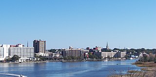
Wilmington is a port city in New Hanover County, North Carolina, United States. With a population of 115,451 as of the 2020 census, it is the eighth-most populous city in the state. The county seat of New Hanover County, it is the principal city of the Wilmington metropolitan area, which includes New Hanover, Brunswick, and Pender counties. As of 2023, the region had an estimated population of 467,337.

The Cape Fear River is a 191.08-mile-long blackwater river in east-central North Carolina. It flows into the Atlantic Ocean near Cape Fear, from which it takes its name. The river is formed at the confluence of the Haw River and the Deep River in the town of Moncure, North Carolina. Its river basin is the largest in the state: 9,149 sq mi.
Northeast Cape Fear River is a 131.2 mi (211.1 km) long 5th order tributary to the Cape Fear River in southeastern North Carolina.

U.S. Route 17 or U.S. Highway 17 (US 17), also known as the Coastal Highway, is a north–south United States Numbered Highway that spans in the Southeastern United States. It runs close to the Atlantic Coast for much of its length, with the exception of the portion between Punta Gorda and Jacksonville, Florida, and the portion from Fredericksburg to Winchester, Virginia, both of which follow a more inland route. Major metropolitan areas served along US 17's route include the Punta Gorda, Greater Orlando, and Jacksonville metropolitan areas in Florida, the Brunswick and Savannah metropolitan areas in Georgia, the Charleston and Myrtle Beach metropolitan areas in South Carolina, the Cape Fear and New Bern metropolitan areas in North Carolina, and the Hampton Roads and Winchester metropolitan areas in Virginia.

U.S. Route 76 is an east–west U.S. highway in the Southeastern United States that travels for 548 miles (882 km). Its western terminus is at US 41 and the eastern terminus of US 72 in the city of Chattanooga, Tennessee, where it travels in a generally due east direction, to its eastern terminus at Wrightsville Beach, North Carolina. It travels through the cities of Chattanooga, Tennessee, Ringgold, Georgia, Columbia and Florence, South Carolina, and Wilmington, North Carolina.
The Cape Fear Skyway was a proposed limited access toll road and bridge in North Carolina, United States, that would pass through portions of New Hanover and Brunswick counties.
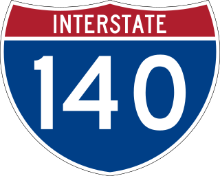
Interstate 140 (I-140) and North Carolina Highway 140 (NC 140) is a 25.4-mile (40.9 km) auxiliary Interstate Highway and state highway in the U.S. state of North Carolina. Officially designated the John Jay Burney Jr. Freeway, it serves as a bypass of Wilmington. The western terminus of the highway is at U.S. Route 17 (US 17) near Winnabow. It heads north in western Leland before turning to the east north of an interchange with U.S. Route 74 (US 74)/U.S. Route 76 (US 76). I-140 crosses the Cape Fear River north of Navassa and the Northeast Cape Fear River northwest of Wrightsboro. I-140 ends at Interstate 40 (I-40), and the route number changes to NC 140. NC 140 continues to the east, ending at US 17 in Kirkland.

Figure Eight Island is a barrier island in the U.S. state of North Carolina, just north of Wrightsville Beach, widely known as an affluent summer colony and vacation destination. The island is part of the Wilmington Metropolitan Area, and lies between the Intracoastal Waterway and the Atlantic Ocean. As a private island, Figure Eight can only be reached by boat or via a guarded causeway swing bridge—the only private bridge over the Intracoastal Waterway in the American Southeast.

The Cape Fear Memorial Bridge is a steel vertical-lift bridge in North Carolina. It carries US 17/US 76/US 421 across the Cape Fear River between Brunswick County and New Hanover County. It also carried U.S. Route 74 until that designation was shifted to the Isabel S. Holmes Bridge. It has a lift span that can be raised 135 feet (41 m). The lift span is 408 feet (124 m) long.

Interstate 40 (I-40) is a part of the Interstate Highway System that travels 2,556.61 miles (4,114.46 km) from Barstow, California, to Wilmington, North Carolina. In North Carolina, I-40 travels 420.21 miles (676.26 km) across the entirety of the state from the Tennessee state line along the Pigeon River Gorge to U.S. Highway 117 (US 117) and North Carolina Highway 132 (NC 132) in Wilmington. I-40 is the longest Interstate Highway in North Carolina and is the only Interstate to completely span the state from west to east.

Interstate 20 (I-20) is the main east–west Interstate Highway in the state of South Carolina, linking the state with important transportation and business hubs to the north, west, and south, including Atlanta, Georgia; Charlotte, North Carolina ; Savannah, Georgia ; and Washington, D.C.. I-20 travels 141.51 miles (227.74 km) west to east, from the Georgia state line at North Augusta, through Columbia, to end at I-95 in Florence. Past I-95, the roadway continues as Interstate 20 Business for about two miles (3.2 km) to U.S. Route 76 (US 76), which goes to downtown Florence.
Cape Fear is a coastal plain and Tidewater region of North Carolina centered about the city of Wilmington. The region takes its name from the adjacent Cape Fear headland, as does the Cape Fear River which flows through the region and empties into the Atlantic Ocean near the cape. Much of the region's populated areas are found along the Atlantic beaches and the Atlantic Intracoastal Waterway, while the rural areas are dominated by farms and swampland like that of the Green Swamp. The general area can be also identified by the titles "Lower Cape Fear", "Wilmington, NC Metropolitan Statistical Area", "Southeastern North Carolina", and "Azalea Coast". The latter name is derived from the North Carolina Azalea Festival held annually in Wilmington. Municipalities in the area belong to the Cape Fear Council of Governments.
A total of at least 32 special routes of U.S. Route 17 (US 17) have existed: 3 in Florida, 6 in South Carolina, 17 in North Carolina, and 6 in Virginia.

U.S. Route 421 (US 421) is part of the United States Numbered Highway System that runs from Fort Fisher, North Carolina to Michigan City, Indiana. In the U.S. state of North Carolina, US 421 travels 328 miles (528 km) from its southern terminus at Fort Fisher to the Tennessee state line near the community of Zionville, North Carolina. US 421 traverses the state from east to west travelling from the coastal plains to Appalachian Mountains. It provides an important connection between the cities of Wilmington, Sanford, Greensboro, Winston-Salem, and Boone. Despite being signed as north–south, much of the routing of US 421 in North Carolina runs in an east–west direction, particularly between Greensboro and the Tennessee state line. Portions of US 421 have been upgraded to freeway standards including the majority of its routing between Sanford and North Wilkesboro.
U.S. Highway 17 (US 17) in the U.S. state of North Carolina is a north–south highway that is known as the Coastal Highway in the southeastern half of the state and the Ocean Highway in other areas. The route enters the state from South Carolina near Calabash and leaves in the vicinity of the Great Dismal Swamp National Wildlife Refuge in Virginia. Between the US 64 freeway and the Virginia state line, US 17 is a four-lane divided highway with speed limits varying between 45 mph (72 km/h) and 70 mph (110 km/h).
U.S. Highway 76 (US 76) is a U.S. Highway running from Chattanooga, Tennessee to Wrightsville Beach, North Carolina. In North Carolina the highway runs for 80.4 miles (129.4 km) in the southeastern region of the state. US 76 enters the state from South Carolina south of Fair Bluff in Columbus County. Travelling in an eastward direction, US 76 meets US 74 in Chadbourn. The two highways run concurrently for 50.4 miles (81.1 km) between Chadbourn and Wilmington. US 76 runs concurrently with US 17 along much of its Wilmington routing, until once again meeting US 74. US 76 and US 74 run concurrently for 1.4 miles (2.3 km) until reaching Wrightsville Beach. US 76 reaches its eastern terminus on the south side of Wrightsville Beach, at an intersection with Water Street.
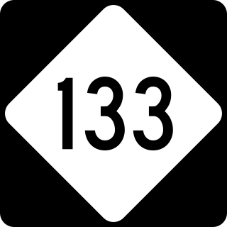
North Carolina Highway 133 (NC 133) is a primary state highway in the U.S. state of North Carolina. It traverses 46.6 miles (75.0 km) from Oak Island Drive in Oak Island to NC 210 in Bells Crossroads. The route serves communities such as Southport, Belville, Leland, Wilmington, and Castle Hayne. Additionally, NC 133 serves as an entry point for Military Ocean Terminal Sunny Point located to its east. Much of NC 133 runs parallel to the Cape Fear River and Brunswick River between Southport and Belville. West of Wilmington, NC 133 runs concurrently with U.S. Route 17 (US 17), US 74, and US 76. The road follows another concurrency along US 74 and US 421, west of Downtown Wilmington, and crosses into New Hanover County on the Isabel Holmes Bridge. North of Wilmington, NC 133 exits to the north, serving several suburban communities north of Wilmington. NC 133 runs concurrently with US 117 through Castle Hayne, before bearing northwest toward Bells Crossroads.
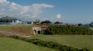
Located in North Carolina on the Atlantic Coast, the Fort Caswell Historic District encompasses 2 sites, 43 buildings, and 23 structures; it was added to the National Register of Historic Places in 2013. The fort itself was occupied by various branches of the U.S. armed forces for most of the period between 1836 and 1945 and is now a part of the North Carolina Baptist Assembly, a Christian retreat, owned and operated by the Baptist State Convention of North Carolina. It is accessible by the public to a limited extent per the conditions set forth by the Assembly’s Director.

