
Geodesy is the Earth science of accurately measuring and understanding Earth's figure, orientation in space, and gravity. The field also incorporates studies of how these properties change over time and equivalent measurements for other planets. Geodynamical phenomena, including crustal motion, tides and polar motion, can be studied by designing global and national control networks, applying space geodesy and terrestrial geodetic techniques and relying on datums and coordinate systems. The job title is geodesist or geodetic surveyor.

The National Oceanic and Atmospheric Administration is an American scientific and regulatory agency within the United States Department of Commerce that forecasts weather, monitors oceanic and atmospheric conditions, charts the seas, conducts deep sea exploration, and manages fishing and protection of marine mammals and endangered species in the U.S. exclusive economic zone.

Mean sea level (MSL) is an average surface level of one or more among Earth's coastal bodies of water from which heights such as elevation may be measured. The global MSL is a type of vertical datum – a standardised geodetic datum – that is used, for example, as a chart datum in cartography and marine navigation, or, in aviation, as the standard sea level at which atmospheric pressure is measured to calibrate altitude and, consequently, aircraft flight levels. A common and relatively straightforward mean sea-level standard is instead the midpoint between a mean low and mean high tide at a particular location.

The World Geodetic System (WGS) is a standard for use in cartography, geodesy, and satellite navigation including GPS. This standard includes the definition of the coordinate system's fundamental and derived constants, the normal gravity Earth Gravitational Model (EGM), a description of the associated World Magnetic Model (WMM), and a current list of local datum transformations.

In geodesy, a reference ellipsoid is a mathematically defined surface that approximates the geoid, which is the truer, imperfect figure of the Earth, or other planetary body, as opposed to a perfect, smooth, and unaltered sphere, which factors in the undulations of the bodies' gravity due to variations in the composition and density of the interior, as well as the subsequent flattening caused by the centrifugal force from the rotation of these massive objects . Because of their relative simplicity, reference ellipsoids are used as a preferred surface on which geodetic network computations are performed and point coordinates such as latitude, longitude, and elevation are defined.

The National Geodetic Survey (NGS), formerly the United States Survey of the Coast (1807–1836), United States Coast Survey (1836–1878), and United States Coast and Geodetic Survey (USC&GS) (1878–1970), is a United States federal agency that defines and manages a national coordinate system, providing the foundation for transportation and communication; mapping and charting; and a large number of applications of science and engineering. Since its foundation in its present form in 1970, it has been part of the National Oceanic and Atmospheric Administration (NOAA), of the United States Department of Commerce.
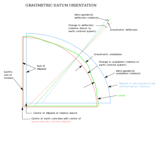
The vertical deflection (VD) or deflection of the vertical (DoV), also known as deflection of the plumb line and astro-geodetic deflection, is a measure of how far the gravity direction at a given point of interest is rotated by local mass anomalies such as nearby mountains. They are widely used in geodesy, for surveying networks and for geophysical purposes.
A geodetic datum or geodetic system is a global datum reference or reference frame for precisely representing the position of locations on Earth or other planetary bodies by means of geodetic coordinates. are crucial to any technology or technique based on spatial location, including geodesy, navigation, surveying, geographic information systems, remote sensing, and cartography. A horizontal datum is used to measure a location across the Earth's surface, in latitude and longitude or another coordinate system; a vertical datum is used to measure the elevation or depth relative to a standard origin, such as mean sea level (MSL). Since the rise of the global positioning system (GPS), the ellipsoid and datum WGS 84 it uses has supplanted most others in many applications. The WGS 84 is intended for global use, unlike most earlier datums.

The Meades Ranch Triangulation Station is a survey marker in Osborne County in the state of Kansas in the Midwestern United States. The marker was initially placed in 1891. From 1901, it was the reference location for establishing a system of horizontal measurement in the United States, known as geodetic datum. In 1913, the datum was adopted across all of North America, and the system revised and formalized as the North American Datum of 1927 (NAD27). A similar reference for vertical measurement was established in 1929 as the National Geodetic Vertical Datum of 1929. The NAD27 was later supplanted by the North American Datum of 1983 (NAD83), which was formally adopted by the United States in 1989 and Canada in 1990; the new system moved the reference point to a point in the earth's core, and the Meades Ranch marker lost its special significance to the geodetic datum system.

The elevation of a geographic location is its height above or below a fixed reference point, most commonly a reference geoid, a mathematical model of the Earth's sea level as an equipotential gravitational surface . The term elevation is mainly used when referring to points on the Earth's surface, while altitude or geopotential height is used for points above the surface, such as an aircraft in flight or a spacecraft in orbit, and depth is used for points below the surface.
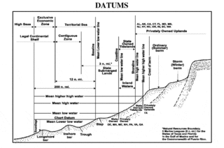
A chart datum is the water level surface serving as origin of depths displayed on a nautical chart. A chart datum is generally derived from some tidal phase. Common chart datums are lowest astronomical tide (LAT) and mean lower low water (MLLW). In non-tidal areas, e.g. the Baltic Sea, mean sea level (MSL) is used.
Geodetic astronomy or astronomical geodesy (astro-geodesy) is the application of astronomical methods into geodetic networks and other technical projects of geodesy.
The orthometric height is the vertical distance H along the plumb line from a point of interest to a reference surface known as the geoid, the vertical datum that approximates mean sea level. Orthometric height is one of the scientific formalizations of a laypersons' "height above sea level", along with other types of heights in Geodesy.
The North American Datum (NAD) is the horizontal datum now used to define the geodetic network in North America. A datum is a formal description of the shape of the Earth along with an "anchor" point for the coordinate system. In surveying, cartography, and land-use planning, two North American Datums are in use for making lateral or "horizontal" measurements: the North American Datum of 1927 (NAD 27) and the North American Datum of 1983 (NAD 83). Both are geodetic reference systems based on slightly different assumptions and measurements.
The National Geodetic Vertical Datum of 1929 is the official name since 1973 of the vertical datum established for vertical control surveying in the United States of America by the General Adjustment of 1929. Originally known as Sea Level Datum of 1929, NGVD 29 was determined and published by the National Geodetic Survey and used to measure the elevation of a point above and depression below mean sea level (MSL).
The North American Vertical Datum of 1988 is the vertical datum for orthometric heights established for vertical control surveying in the United States of America based upon the General Adjustment of the North American Datum of 1988.

In geodesy, surveying, hydrography and navigation, vertical datum or altimetric datum, is a reference surface for vertical positions, such as the elevations of Earth-bound features and altitudes of satellite orbits and in aviation. In planetary science, vertical datums are also known as zero-elevation surface or zero-level reference.
The National Spatial Reference System (NSRS), managed by the National Geodetic Survey (NGS), is a coordinate system that includes latitude, longitude, elevation, and other values. The NSRS consists of a National Shoreline, the National CORS, a network of permanently marked points, and a set of models that describe dynamic geophysical processes affecting spatial measurements. Pre-2022, the system is based on NAD 83 and NAVD 88.

Irene Kaminka Fischer was an Austrian-American mathematician and geodesist. She was a member of the National Academy of Engineering, a Fellow of the American Geophysical Union, and inductee of the National Imagery and Mapping Agency Hall of Fame. Fischer became one of two internationally known women scientists in the field of geodesy during the golden age of the Project Mercury and the Apollo moon mission. Her Mercury datum, as well as her work on the lunar parallax, were instrumental in conducting these missions. "In his preface to the ACSM publication, Fischer's former colleague, Bernard Chovitz, referred to her as one of the most renowned geodesists of the third quarter of the twentieth century. Yet this fact alone makes her one of the most renowned geodesists of all times, because, according to Chovitz, the third quarter of the twentieth century witnessed "the transition of geodesy from a regional to a global enterprise."

VERTCON is a computer program that computes the modeled difference in orthometric height between the North American Vertical Datum of 1988 and the National Geodetic Vertical Datum of 1929 for a location in the contiguous United States. The parameters required are the latitude and longitude of the location.
