Barrasford is a village in Northumberland, England. It is situated to the north of Hexham, on the North Tyne. Barrasford is an ancient village that lies within the shadow of Haughton Castle. The village is notable for being the location of a Bronze Age burial site where the Reaverhill Dagger was excavated in 1964. Today Barrasford is noted for its quarry.
Charlton is a village in Northumberland, England. It is about 1.5 miles (2.4 km) to the northwest of Bellingham, on the River North Tyne.
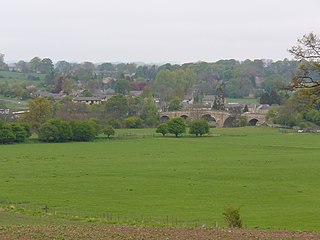
Chollerford is a village in Northumberland, England, approximately four miles north of Hexham on the B6318, the Military Road, not far from Hadrian's Wall. There is a roundabout in the village where the B6318 and B6320 roads meet and the traffic light-controlled Chollerford Bridge crosses the River North Tyne. Beside the river is The George Hotel.
Chollerton is a village in Northumberland, England, on the A6079 road about six miles (10 km) to the north of Hexham, on the River North Tyne. Nearby villages include Low Brunton and Humshaugh. The village has a fine example of a mounting block standing at the churchyard gate.

Wark on Tyne is a small village and civil parish in Northumberland, England, 12 miles (19 km) north of Hexham.

Falstone is a small village in Northumberland, England, just east of Kielder Water. The village is 8 miles (13 km) from the Anglo–Scottish border. Much of the village is clustered around its two churches, St. Peter's Anglican and the United Reformed Church.

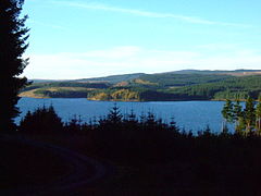
Kielder is a small, remote village in western Northumberland, England. Located at the head of Kielder Water and in the north west of Kielder Forest, the village is within three miles of the Scottish border.
Tarset is a civil parish in Northumberland, England, created in 1955 from parts of Bellingham, Tarset West and Thorneyburn parishes. It is 4 miles (6 km) west-north-west of Bellingham. Today it shares a parish council with the adjacent parish of Greystead. It is partly located within the Northumberland National Park, and also mostly within the international dark skies park.

Wall is a village in Northumberland, England situated to the north of Hexham close by the River North Tyne and Hadrian's Wall. The Battle of Heavenfield was fought nearby. The village has one pub and a garage.
Redesmouth is a village in Northumberland, England, just over 1 mile (1.6 km) to the south-east of Bellingham.
The Border Counties Railway was a railway line connecting Hexham in Northumberland, with Riccarton Junction on the Waverley Route in Roxburghshire.

Riccarton Junction, in the county of Roxburghshire in the Scottish Borders, was a railway village and station. In its heyday it had 118 residents and its own school, post office and grocery store. The station was an interchange between the Border Counties Railway branch to Hexham and the North British Railway's (NBR's) Border Union Railway.

Angerton was a railway station serving the village of Low Angerton in Northumberland, Northern England. It was located on the Wansbeck Railway, which diverged from the East Coast Main Line at Morpeth and joined the Border Counties Railway at Reedsmouth Junction.
Thorneyburn is a village and former civil parish, now in the parish of Tarset, in Northumberland, England, to the northwest of Bellingham. In 1951 the parish had a population of 74.
Plashetts is a small settlement in Northumberland, in England south east of Kielder, Northumberland. It is about 22 miles (35 km) north west of Hexham. Part of the settlement is now beneath the surface of Kielder Water.
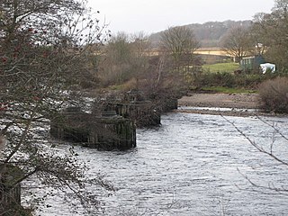
Border Counties Bridge was a 19th-century railway bridge across the River Tyne just west of Hexham, Northumberland, England. The bridge used to carry the Border Counties Railway over the River Tyne at Border Counties Junction with the Newcastle and Carlisle Railway.

The Tyne Valley Line is a 58-mile (93 km) route, linking Newcastle upon Tyne with Hexham and Carlisle, England. The line follows the course of the River Tyne through Tyne and Wear and Northumberland. Five stations and two viaducts on the route are listed structures.
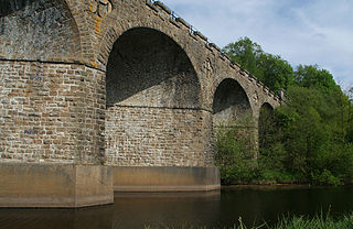
Kielder Viaduct consists of seven semi-circular masonry skew arches and was built in 1862 by the North British Railway to carry the Border Counties Line across marshy land, which following flooding to create Kielder Water, became the place where Deadwater Burn joins Bakethin Reservoir. Now closed to rail traffic, the bridge is currently used as a footpath.

Staward Halt is a closed stone built railway station situated on a single track branch railway line in Northumberland, England, that ran from Allendale through to Hexham.

Lambley was a railway station on the Alston Branch Line, which ran between Haltwhistle and Alston. The station, situated 4+3⁄4 miles (8 km) south-west of Haltwhistle, served the village of Lambley in Northumberland.