
Pike County is a county in the Commonwealth of Pennsylvania. As of the 2020 census, the population was 58,535. Its county seat is Milford. The county is part of the Northeast Pennsylvania region of the state.

The Dingman's Ferry Bridge is a toll bridge across the Delaware River between Delaware Township, Pennsylvania and Sandyston Township, New Jersey. Owned and operated by the Dingmans Choice and Delaware Bridge Company, it is the last privately-owned toll bridge on the Delaware and one of the few remaining in the United States. It is also the only bridge on the Delaware to toll traffic entering New Jersey.
Dingmans Ferry is an unincorporated community in Delaware Township, Pike County, Pennsylvania, United States. As of 2014, it had a population of just over 1,000 people. It was originally sited on the Delaware River, in an area now included in the Delaware Water Gap National Recreation Area. When the Corps of Engineers acquired the land by eminent domain in the mid-twentieth century for the creation of the proposed Tocks Island Dam project, it relocated the community further up the hill.
Delaware Water Gap National Recreation Area is a 70,000-acre (28,000 ha) national recreation area administered by the National Park Service in northwest New Jersey and northeast Pennsylvania. It is centered around a 40-mile (64 km) stretch of the Delaware River designated the Middle Delaware National Scenic River. At the area's southern end lays the Delaware Water Gap, a dramatic mountain pass where the river cuts between Blue Mountain and Kittatinny Mountain.
Holly River State Park is a state park located in Webster County, West Virginia. Situated on the Left Fork of the Holly River near the town of Hacker Valley, it is the second largest park in the West Virginia state park system with a total of 8,294 acres (3,356 ha). The park features over 42 miles (68 km) of hiking trails, ten vacation cabins, an 88-unit campground, and many recreation and picnic areas.

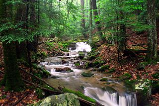
The George W. Childs Recreation Site is a former Pennsylvania state park that is the site of a number of cascade waterfalls along Dingmans Creek; it has been part of the Delaware Water Gap National Recreation Area since 1983. It is located in Dingmans Ferry in Delaware Township, Pike County, Pennsylvania and is named for the late newspaper publisher George William Childs, whose widow deeded the land to the Commonwealth of Pennsylvania in 1912. The site contains three main waterfalls: Factory Falls, Fulmer Falls and Deer Leap Falls and is a few miles upstream from Dingmans Falls and Silverthread Falls.

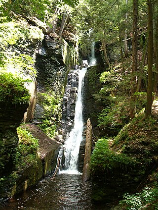
Silverthread Falls is a waterfall located in Dingmans Ferry in Delaware Township, Pike County, Pennsylvania, United States, near Dingmans Falls in the Delaware Water Gap National Recreation Area. It has a vertical drop of 24.3 m (80 ft). Both Silverthread Falls and Dingmans Falls are visible from a handicap-accessible trail. The trail begins at the parking lot for the Dingmans Falls Visitor Center.
Dingmans Falls is a waterfall located in Dingmans Ferry in Delaware Township, Pennsylvania near the Silverthread Falls. It has a vertical drop of 39.6 m (130 ft). Both Silverthread Falls and Dingmans Falls are visible from a handicap-accessible trail. The trail begins at the parking lot for the Dingmans Falls Visitor Center.
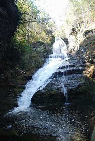
Fulmer Falls is the second waterfall located in the George W. Childs Recreation Site in Dingmans Ferry, Pike County, Pennsylvania, United States of America. The falls are downstream from Factory Falls and upstream from Deer Leap Falls on the Dingmans Creek. At 17 meters, it is the largest of the three falls.

Difficult Run is a 15.9-mile-long (25.6 km) tributary stream of the Potomac River in Northern Virginia in the United States. The area has had many historical uses dating back to the early 1800s. Today, the area is used recreationally by visitors interested in the watershed's variety of options including hiking, biking, fishing, boating, climbing, and bird watching. The wildlife at Difficult Run is vast as 163 different species can be seen depending on the season. There are 41 different soil types found on the trail and alongside the stream. The stream is part of the greater 57.7- square-mile Drainage basin, or watershed, located in the north-central portion of Fairfax County and drains directly to the Potomac River.

Bushkill Falls is a series of eight privately owned waterfalls, the tallest of which cascades over 100 feet (30 m), located in Lehman Township, Pennsylvania in the Pocono Mountains. Water of the Little Bush Kill and Pond Run Creek descends the mountain, toward the Delaware River, forming Bushkill Falls, Bridal Veil Falls, Bridesmaid Falls, Laurel Glen Falls, Pennell Falls, and three additional, unnamed falls.

State Quadrant Route 2001 in Pike County, Pennsylvania is a 22-mile (35 km) road in Dingman, Lehman, Delaware and Milford Townships. Formerly Pennsylvania Route 962 in part, the road stretches from U.S. Route 209 in Lehman Township to West Harford Street in downtown Milford. There are very few notable roads that intersect with SR 2001, the main three being Pennsylvania Route 739, Log Tavern Road and Raymondskill Road.
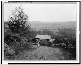
Conashaugh, Pennsylvania is a ghost town in Delaware Township, Pike County, Pennsylvania between Dingmans Ferry, Pennsylvania, Milford, Pennsylvania and Birchwood Lakes, Pennsylvania. It is along the Delaware River bordering New Jersey and is now a part of the Delaware Water Gap National Recreation Area. It was originally occupied by American Civil War deserters, and is now considered a ghost town due to the decline of its original population.
Eshback, Pennsylvania is a ghost town in Lehman Township, Pike County, Pennsylvania near Dingmans Ferry, Pennsylvania and Bushkill, Pennsylvania. It is now a part of the Delaware Water Gap National Recreation Area, and the Eshback Boat Launch remains in the park.

The Callahan House, also known as the Jacob Helm House, is a historic home located in the Delaware Water Gap National Recreation Area south of Milford, in Dingman Township, Pike County, Pennsylvania. It was built in two sections, with the older dated to about 1800 and the later to about 1820. It is a long, 1+1⁄2-story, clapboard-clad frame dwelling with a steep gable roof. It features exposed chimney backs at the first floor exterior in the Dutch style, and a porch along the newer wing.

Sunrise Lake is a census-designated place and private lake community located in Dingman Township, Pike County in the state of Pennsylvania. The community is located along Pennsylvania Route 739 in eastern Pike County, about eight miles west of the New Jersey state line at the Delaware River. Sunrise Lake is between, and shares borders with, the CDP communities of Conashaugh Lakes and Gold Key Lake. Sunrise Lake shares its name with the lake of the same name that the community surrounds. As of the 2020 census, the population was 1,396 residents.

Heberly Run is a tributary of East Branch Fishing Creek in Sullivan County, Pennsylvania, in the United States. It is approximately 4.9 miles (7.9 km) long and flows through Davidson Township. The watershed of the stream has an area of 6.42 square miles (16.6 km2). Its tributaries include Quinn Run and Meeker Run. The stream also has a number of waterfalls. It is partly in Pennsylvania State Game Lands Number 13. The forests near the stream largely consist of second-growth woods.
Sullivan Branch is a tributary of East Branch Fishing Creek in Sullivan County, Pennsylvania, in the United States. It is approximately 3.3 miles (5.3 km) long and flows through Davidson Township.

Gifford Pinchot State Park is a 2,338-acre (946 ha) Pennsylvania state park in northern York County, Pennsylvania, in the United States.

