Sandyston Township is a small rural township in Sussex County, in the U.S. state of New Jersey. It is located in the northwestern part of the state near the Pennsylvania border. The township is surrounded by and part of many national and state parks. As of the 2020 United States census, the township's population was 1,977, a decrease of 21 (−1.1%) from the 2010 census count of 1,998, which in turn reflected an increase of 173 (+9.5%) from the 1,825 counted in the 2000 census. Sandyston's growth in recent years has been attributed to the influx of people from more urban parts of the state and even New York City, located less than 75 miles (121 km) away.

Walpack Township is a township in Sussex County, in the U.S. state of New Jersey. As of the 2020 United States census, the township's population was 7, a decrease of 9 (−56.3%) from the 2010 census count of 16, which in turn reflected a decline of 34 (−82.9%) from the 41 counted in the 2000 census. Walpack Township was the smallest municipality by population and one of only four municipalities in New Jersey with a population under 100 as of the 2020 Census; it had the state's third-smallest population in the 2010 census, behind Tavistock and the now-defunct Pine Valley, both in Camden County.
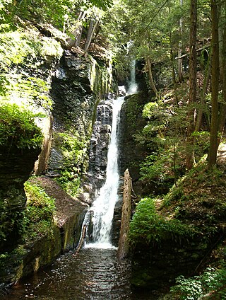
Delaware Water Gap National Recreation Area is a 70,000-acre (28,000 ha) national recreation area administered by the National Park Service in northwest New Jersey and northeast Pennsylvania. It is centered around a 40-mile (64 km) stretch of the Delaware River designated the Middle Delaware National Scenic River. At the area's southern end lays the Delaware Water Gap, a dramatic mountain pass where the river cuts between Blue Mountain and Kittatinny Mountain.
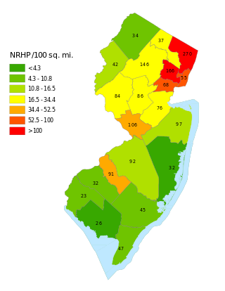
This is a list of properties and districts listed on the National Register of Historic Places in New Jersey. There are more than 1,700 listed sites in New Jersey. Of these, 58 are further designated as National Historic Landmarks. All 21 counties in New Jersey have listings on the National Register.
This National Park Service list is complete through NPS recent listings posted April 26, 2024.

County Route 560 is a county highway in the U.S. state of New Jersey. The highway extends 5.05 miles (8.13 km) from U.S. Route 206 and County Route 521 in Sandyston Township. CR 560 ends at the Pennsylvania state line, where it becomes Pike County Quadrant Route 2019, which connects to Pennsylvania Route 739. CR 560's entire length is in Sandyston. However, CR 560 does pass through the hamlet of Layton.
National Park Route 615 is a route through the Delaware Water Gap National Recreation Area. The route consists of two parts, County Route 615, maintained by Sussex County, New Jersey, with the remainder of the route maintained by the National Park Service.

The Pahaquarry Copper Mine is an abandoned copper mine located on the west side of Kittatinny Mountain presently in Hardwick Township in Warren County, New Jersey in the United States. Active mining was attempted for brief periods during the mid-eighteenth, mid-nineteenth, and early twentieth centuries but was never successful despite developments in mining technology and improving mineral extraction methods. Such ventures were not profitable as the ore extracted proved to be of too low a concentration of copper. This site incorporates the mining ruins, hiking trails, and nearby waterfalls, and is located within the Delaware Water Gap National Recreation Area and administered by the National Park Service. It was added to the National Register of Historic Places in 1980 as a contributing property to the Old Mine Road Historic District.

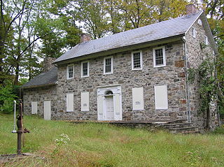
The Andrew Snable House is a historic house located on Sandyston-Haney's Mill Road near Wallpack Center in Walpack Township of Sussex County, New Jersey. It was added to the National Register of Historic Places on July 23, 1979, for its significance in architecture and exploration/settlement.

The Minisink or Minisink Valley is a loosely defined geographic region of the Upper Delaware River valley in northwestern New Jersey, northeastern Pennsylvania and New York.

Van Campen's Inn or Isaac Van Campen Inn is a fieldstone residence that was used as a yaugh house during the American colonial era. Located in Walpack Township, Sussex County, New Jersey along the Delaware River, it is a historic site located along the Old Mine Road in the Delaware Water Gap National Recreation Area. It is operated under a memorandum of understanding between the National Park Service and the Walpack Historical Society, a local non-profit corporation.

Wallpack Center is an unincorporated community located within Walpack Township, Sussex County, in the U.S. state of New Jersey. Wallpack Center is located in the Flat Brook Valley 6.7 miles (10.8 km) west of Branchville. Wallpack Center has a post office with ZIP Code 07881. It is now part of the Delaware Water Gap National Recreation Area.
Amsterdam is an unincorporated community located within Holland Township in Hunterdon County, in the U.S. state of New Jersey. Located on the southern flank of the Musconetcong Mountain, the area was settled in the first half of the 18th century. It was later named after Amsterdam, Netherlands. The Amsterdam Historic District, encompassing the community, was listed on the state and national registers of historic places in 1995.

Flatbrookville is an unincorporated community located along Old Mine Road within Walpack Township, in Sussex County, in the U.S. state of New Jersey. It is named after the Flat Brook, a tributary of the Delaware River, which flows through the community. The area is now part of the Delaware Water Gap National Recreation Area.

Millbrook, also known as Millbrook Village, is an unincorporated community located along Old Mine Road within Hardwick Township, formerly Pahaquarry Township, in Warren County, in the U.S. state of New Jersey. It is named after the Mill Brook, now known as Van Campens Mill Brook, a tributary of the Delaware River. The area is now part of the Delaware Water Gap National Recreation Area.

The Rocky Hill Historic District is a 176-acre (71 ha) historic district encompassing the historic core of the borough of Rocky Hill in Somerset County, New Jersey. The village is approximately one square mile and traces its beginnings to the 18th century, when George Washington stayed at Rockingham, and its major growth period to the second quarter of the 19th century. Located along Washington Street and Montgomery, Princeton, and Crescent Avenues, the district encompasses 145 buildings, only 12 of which are non-contributing, and has sustained its historic character without the intrusion of modern structures or parking lots. The most notable landmark in the village is Dutch Reformed Church, built in 1856 in the Carpenter Gothic style. The district was added to the National Register of Historic Places on July 8, 1982, for its significance in archeology, architecture and commerce.
The Old Mine Road Historic District is a 687-acre (278 ha) historic district located along Old Mine Road in Sussex County and Warren County, New Jersey. It is part of the Delaware Water Gap National Recreation Area. The district was added to the National Register of Historic Places on December 3, 1980, for its significance in agriculture, archaeology, architecture, commerce, exploration/settlement, and transportation. It includes 24 contributing buildings and five contributing sites.

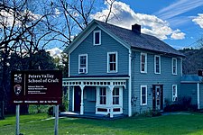
Peters Valley School of Crafts, is a nonprofit arts organization and craft school within the Delaware Water Gap National Recreation Area in Layton, New Jersey. It is located an hour and a half drive from New York City, and is part of the NRHP-listed Peters Valley Historic District.

The Foster–Armstrong House is a historic house museum located at 320 River Road in Montague Township of Sussex County, New Jersey. It was documented by the Historic American Buildings Survey in 1970. It was added to the National Register of Historic Places on July 23, 1979, for its significance in agriculture, architecture, commerce, and exploration/settlement. The house is now part of the Delaware Water Gap National Recreation Area. The museum is managed by the Montague Association for the Restoration of Community History.

Millville is an unincorporated community located along River Road and Shimers Brook in Montague Township of Sussex County, New Jersey. The Montague Grange and other parts of the community are in the Delaware Water Gap National Recreation Area.
The Richard Layton House is a historic farmhouse located in the valley of the Delaware River southwest of the Wallpack Center section of Walpack Township in Sussex County, New Jersey, United States. It was added to the National Register of Historic Places on July 23, 1979, for its significance in architecture. The house is now part of the Delaware Water Gap National Recreation Area.