Hainesville, New Jersey

Last updated

Hainesville, New Jersey
Location map of Sussex County, New Jersey.svg
Red pog.svg
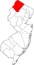
Hainesville, New Jersey
Hainesville's location in Sussex County (Inset: Sussex County in New Jersey)
USA New Jersey location map.svg
Red pog.svg
Hainesville, New Jersey
Hainesville, New Jersey (New Jersey)
Usa edcp location map.svg
Red pog.svg
Hainesville, New Jersey
Hainesville, New Jersey (the United States)
Coordinates: 41°15′07″N74°48′12″W / 41.25194°N 74.80333°W / 41.25194; -74.80333
Country Flag of the United States.svg  United States
State Flag of New Jersey.svg  New Jersey
County Sussex
Township Sandyston
Named for Daniel Haines
Elevation
190 m (620 ft)
Time zone Eastern (EST)
  Summer (DST)EDT

Hainesville is an unincorporated community located within Sandyston Township, in Sussex County, New Jersey, United States. [1] It lies along a stretch of County Route 645, known as the Layton-Hainesville Road, that runs parallel to U.S. Route 206 and connects to County Route 675. It is adjacent to the Delaware Water Gap National Recreation Area, and near the towns of Shaytown and Layton. Its coordinates are latitude 41.25194 and longitude −74.80333. It is 620 feet (190 meters) above sea level. [2]

Contents

Named for Daniel Haines, governor of New Jersey from 1843 to 1844 and from 1845 to 1848, [3] it is in Area code 973, and ZIP Code 07826, both of which it shares with Branchville, New Jersey. [4]

Description

Hainesville and environs is home to the Hainesville General Store, Hidden Acres Golf Course, the Hainesville Fish and Wildlife Management Area, [5] a body of water known as the Hainesville Pond, and the Hainesville Cemetery c. 1879 and Shaytown Burial Ground c. 1812. [6] The Catholic parish St. Thomas the Apostle is actually located in nearby Layton. [7]

Notable people

People who were born in, residents of, or otherwise closely associated with Hainesville include:

Related Research Articles

<span class="mw-page-title-main">Sussex County, New Jersey</span> County in New Jersey, United States

Sussex County is the northernmost county in the U.S. state of New Jersey. Its county seat is Newton. It is part of the New York metropolitan area and is part of New Jersey's Skylands Region. As of the 2020 census, the county was the state's 17th-most-populous county, with a population of 144,221, a decrease of 5,044 (−3.4%) from the 2010 census count of 149,265, which in turn reflected an increase of 5,099 (+3.5%) over the 144,166 persons at the 2000 census. Based on 2020 census data, Vernon Township was the county's largest in both population and area, with a population of 22,358 and covering an area of 70.59 square miles (182.8 km2).

<span class="mw-page-title-main">Hardyston Township, New Jersey</span> Township in Sussex County, New Jersey, United States

Hardyston Township is a township in Sussex County, in the U.S. state of New Jersey. As of the 2020 United States census, the township's population was 8,125, a decrease of 88 (−1.1%) from the 2010 census count of 8,213, which in turn reflected an increase of 2,042 (+33.1%) from the 6,171 counted in the 2000 census.

<span class="mw-page-title-main">Newton, New Jersey</span> Town in Sussex County, New Jersey, United States

Newton, officially the Town of Newton, is an incorporated municipality and the county seat of Sussex County in the U.S. state of New Jersey, situated approximately 60 miles (97 km) northwest of New York City. As of the 2020 United States census, the town's population was 8,374, its highest decennial population ever, an increase of 377 (+4.7%) from the 2010 census count of 7,997, which in turn reflected a decrease of 247 (−3.0%) from the 8,244 counted in the 2000 census.

<span class="mw-page-title-main">Sandyston Township, New Jersey</span> Township in Sussex County, New Jersey, United States

Sandyston Township is a small rural township in Sussex County, in the U.S. state of New Jersey. It is located in the northwestern part of the state near the Pennsylvania border. The township is surrounded by and part of many national and state parks. As of the 2020 United States census, the township's population was 1,977, a decrease of 21 (−1.1%) from the 2010 census count of 1,998, which in turn reflected an increase of 173 (+9.5%) from the 1,825 counted in the 2000 census. Sandyston's growth in recent years has been attributed to the influx of people from more urban parts of the state and even New York City, located less than 75 miles (121 km) away.

Augusta is an unincorporated community located within Frankford Township, in Sussex County, New Jersey, United States. As of the 2010 United States Census, the population for the ZIP Code Tabulation Area 07822 was 887.

<span class="mw-page-title-main">Paulins Kill</span> River in New Jersey, United States

The Paulins Kill is a 41.6-mile (66.9 km) tributary of the Delaware River in northwestern New Jersey in the United States. With a long-term median flow rate of 76 cubic feet of water per second (2.15 m³/s), it is New Jersey's third-largest contributor to the Delaware River, behind the Musconetcong River and Maurice River. The river drains an area of 176.85 square miles (458.0 km2) across portions of Sussex and Warren counties and 11 municipalities. It flows north from its source near Newton, and then turns southwest. The river sits in the Ridge and Valley geophysical province.

<span class="mw-page-title-main">Papakating Creek</span> Creek in Sussex County, New Jersey, U.S.

Papakating Creek is a 20.1-mile-long (32.3 km) tributary of the Wallkill River located in Frankford and Wantage townships in Sussex County, New Jersey in the United States. The creek rises in a small swamp located beneath the eastern face of Kittatinny Mountain in Frankford and its waters join the Wallkill to the east of Sussex borough.

<span class="mw-page-title-main">Baker, West Virginia</span> Unincorporated community in West Virginia, United States

Baker is an unincorporated community on the Lost River in Hardy County, West Virginia, United States. Baker is located at the intersection of U.S. Route 48, West Virginia Route 55, West Virginia Route 29 and West Virginia Route 259. The ZCTA population for Baker's ZIP Code was 1,262 at the 2000 census, though the zip code covers a much larger area than the actual community itself.

<span class="mw-page-title-main">Hibernia, New Jersey</span> Populated place in Morris County, New Jersey, US

Hibernia is an unincorporated community and census-designated place (CDP) located along County Route 513 in Rockaway Township of Morris County, in the U.S. state of New Jersey. The area is served as United States Postal Service ZIP Code 07842. The community takes its name from Hibernia, the classical name for Ireland.

<span class="mw-page-title-main">Layton, New Jersey</span> Populated place in Sussex County, New Jersey, US

Layton is an unincorporated community and census-designated place (CDP) located within Sandyston Township in Sussex County, in the U.S. state of New Jersey. The area is served as United States Postal Service ZIP Code 07851.

<span class="mw-page-title-main">Swartswood State Park</span> State park in Sussex County, New Jersey

Swartswood State Park is a 3,460-acre (14.0 km2) protected area located in the Swartswood section of Stillwater and Hampton townships in Sussex County, New Jersey, in the United States. Established in 1915 by the state's Forest Park Reservation Commission, it was the first state park established by the state of New Jersey for the purposes of recreation at the state's third-largest freshwater lake. Today, Swartswood State Park is operated and maintained by the New Jersey Division of Parks and Forestry.

<span class="mw-page-title-main">McAfee, New Jersey</span> Unincorporated community in New Jersey, United States

McAfee is an unincorporated community located within Vernon Township in Sussex County, New Jersey, United States. The area is served as United States Postal Service ZIP Code 07428.

Franklinville is an unincorporated community and census-designated place (CDP) located within Franklin Township in Gloucester County, in the U.S. state of New Jersey. The area is served as United States Postal Service ZIP Code 08322.

<span class="mw-page-title-main">Naubinway, Michigan</span> Census-designated place in Michigan, United States

Naubinway is an unincorporated community and census-designated place (CDP) in Mackinac County in the U.S. state of Michigan. The population of the CDP was 147 at the 2020 census, the first year that it was recorded by the census. The community is located within Garfield Township.

<span class="mw-page-title-main">Green Creek, New Jersey</span> Populated place in Cape May County, New Jersey, US

Green Creek is an unincorporated community located within Middle Township, in Cape May County, in the U.S. state of New Jersey. It is located on Route 47. It is a very low-lying area with a highest elevation of just above 20 feet (6.1 m). The community is located about 3 miles (4.8 km) west of Rio Grande and about 2 miles (3.2 km) from the Delaware Bay. It is mostly residential with areas of agriculture and commerce along the main road, Delsea Drive. The United States Postal Service ZIP Code is 08219. The post office was established in 1829 with Matthew Marcy as the first postmaster.

St. Thomas is an unincorporated community in Derrynane Township, Le Sueur County, Minnesota, United States.

<span class="mw-page-title-main">Lancing, Tennessee</span> Unincorporated community in Tennessee, United States

Lancing is an unincorporated community in Morgan County, Tennessee, United States. Lancing is located along Tennessee State Route 62 and the Norfolk Southern Railway 3.35 miles (5.39 km) west-northwest of Wartburg, and northeast of the Catoosa Wildlife Management Area. Lancing has a post office with ZIP code 37770.

<span class="mw-page-title-main">Wallpack Center, New Jersey</span> Populated place in Sussex County, New Jersey, US

Wallpack Center is an unincorporated community located within Walpack Township, Sussex County, in the U.S. state of New Jersey. Wallpack Center is located in the Flat Brook Valley 6.7 miles (10.8 km) west of Branchville. Wallpack Center has a post office with ZIP Code 07881. It is now part of the Delaware Water Gap National Recreation Area.

<span class="mw-page-title-main">Christ Church, Newton</span> Historic church in New Jersey, United States

Christ Church, also known as Christ Episcopal Church, is a Christian house of worship located on the corner of Church Street and Main Street in Newton, New Jersey. It is a parish overseen by the Episcopal Diocese of Newark, a diocese of the Episcopal Church in the United States of America. The congregation first met on 28 December 1769 and was granted a charter by New Jersey's last Royal Governor William Franklin on behalf of Britain's King George III. Christ Church is the oldest church in Newton and the third oldest parish in the Diocese of Newark.

<span class="mw-page-title-main">Lake Neepaulin</span> Lake of Sussex County, New Jersey, United States

Lake Neepaulin is a small man-made freshwater lake located in Wantage Township in Sussex County, New Jersey in the United States. Located in the watershed of Papakating Creek, a tributary of the Wallkill River, the lake was created in the 1950s by damming an unnamed mountain stream as the feature of a private residential development. The stream, now known as Neepaulakating Creek, did not receive a name until 2002.

References

  1. Locality Search, State of New Jersey. Retrieved June 9, 2016.
  2. Roadside Thoughts: Hainesville, New Jersey (NJ)
  3. The Origin of New Jersey Place Names
  4. Hometown Locator: ZIP Code 07826
  5. "Hainesville Wildlife Management Area" (PDF). New Jersey Department of Environmental Protection. Retrieved July 2, 2020.
  6. Sweetman, Jennie (December 22, 2012). "Shaytown, Hainesville cemeteries receive new sign". NewJerseyHerald.com. New Jersey Herald. Retrieved July 2, 2020.
  7. Parishes Online: St Thomas The Apostle Parish (Hainesville)
  8. The Political Graveyard: Miscellaneous Areas, New Jersey