Vernon Township is a township in Sussex County, in the U.S. state of New Jersey. It is located about a one hour drive from New York City and is part of the New York Metropolitan Area. As of the 2020 United States census, the township's population was 22,358, a decrease of 1,585 (−6.6%) from the 2010 census count of 23,943, which in turn reflected a decline of 743 (−3.0%) from the 24,686 counted in the 2000 census. It is both the most populous municipality and the largest in area in the county.
Augusta is an unincorporated community located within Frankford Township, in Sussex County, New Jersey, United States. As of the 2010 United States Census, the population for the ZIP Code Tabulation Area 07822 was 887.

Chatsworth is an unincorporated community located within Woodland Township in Burlington County, New Jersey, United States. The area is served as United States Postal Service ZIP Code 08019. The New Jersey Central's Blue Comet passenger train was wrecked here in 1939. Chatsworth has been called "Capital of the Pine Barrens."

New Vernon is an unincorporated community and census-designated place located within Harding Township in Morris County, in the U.S. state of New Jersey. The community falls within the boundaries of Harding Township along with a portion of Green Village. New Vernon is the location of the governmental offices for Harding Township.
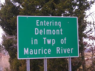
Delmont is an unincorporated community and census-designated place (CDP) located within Maurice River Township, in Cumberland County, in the U.S. state of New Jersey. The area is served as United States Postal Service ZIP Code 08314. It was first listed as a CDP in the 2020 census with a population of 122.
Kirkwood is an unincorporated community located within Voorhees Township in Camden County, in the U.S. state of New Jersey. Kirkwood once had a post office assigned United States Postal Service ZIP Code 08043. The ZIP Code has been reassigned to a post office named Voorhees that serves the entire township. Kirkwood is still a valid city name for mailing purposes.

Hibernia is an unincorporated community and census-designated place (CDP) located along County Route 513 in Rockaway Township of Morris County, in the U.S. state of New Jersey. The area is served as United States Postal Service ZIP Code 07842. The community takes its name from Hibernia, the classical name for Ireland.

Layton is an unincorporated community and census-designated place (CDP) located within Sandyston Township in Sussex County, in the U.S. state of New Jersey. The area is served as United States Postal Service ZIP Code 07851.

Delaware is an unincorporated community and census-designated place (CDP) located along the Delaware River within Knowlton Township in Warren County, New Jersey. It was created as part of the 2010 United States Census. As of the 2010 Census, the CDP's population was 150. The area is served as United States Postal Service ZIP Code 07833.
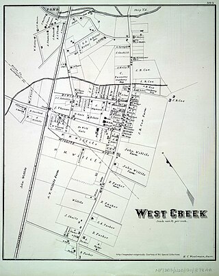
West Creek is an unincorporated community and hamlet located within Eagleswood Township in Ocean County, in the U.S. state of New Jersey.
Glenwood is an unincorporated area located within Vernon Township, in Sussex County, in the U.S. state of New Jersey. The area is served as United States Postal Service ZIP Code 07418.

Richland is an unincorporated community and census-designated place (CDP) located within Buena Vista Township in Atlantic County, in the U.S. state of New Jersey. The area is served as United States Postal Service ZIP Code 08350.

Pottersville is an unincorporated community and census-designated place (CDP) split between Bedminster Township in Somerset County and Tewksbury Township in Hunterdon County, in the U.S. state of New Jersey. The area is served as United States Postal Service ZIP Code 07979. As of the 2010 United States Census, the population for ZIP Code Tabulation Area 07979 was 589. In 1990, most of the village was listed on the National Register of Historic Places as the Pottersville Village Historic District.
Oak Ridge is an unincorporated community and census-designated place (CDP) located along the border of West Milford Township in Passaic County and Jefferson Township in Morris County, in the U.S. state of New Jersey. The area is served as United States Postal Service ZIP Code 07438.
Franklinville is an unincorporated community and census-designated place (CDP) located within Franklin Township in Gloucester County, in the Philadelphia Metropolitan Area in the U.S. state of New Jersey. The area is served as United States Postal Service ZIP Code 08322.

Jobstown is an unincorporated community and census-designated place (CDP) located within Springfield Township in Burlington County, in the U.S. state of New Jersey. The area is served as United States Postal Service ZIP Code 08041.

Clairfield is an unincorporated community in Claiborne County, Tennessee, United States. It is located in the upper Clearfork Valley in the Cumberland Mountains of northeastern Tennessee. It is the site of a post office, assigned ZIP code 37715. The population of the Zip Code Tabulation Area corresponding to Clairfield's ZIP code was 1,002 as of the 2000 Census.

Brookside is a historic unincorporated community and census-designated place (CDP) located within Mendham Township in Morris County, in the U.S. state of New Jersey. It is located approximately 6 mi (9.7 km) west of Morristown. It is close to the Washington Valley Historic District in neighboring Morris Township.
Monroeville is an unincorporated community located within portions of Elk Township in Gloucester County and Upper Pittsgrove Township in Salem County, in the U.S. state of New Jersey. The area is served as United States Postal Service ZIP Code 08343. Monroeville is mostly filled with wooded areas and farms.

Ocean View is an unincorporated community and census-designated place (CDP) located within Dennis Township in Cape May County, in the U.S. state of New Jersey. The area is served as United States Postal Service ZIP Code 08230. The post office was established in 1872, with William Doolittle as the first postmaster.