The community got its name from the gristmills and sawmills built along Shimers Brook, then known as Chambers Mill Brook,[4] starting in 1722. During the American Revolutionary War, Captains Abram Shimer and James Bonell were at the fort located here to protect the mills.[5] Shimer built a mill here c.1750.[6] In the 1790s, Jacob Shimer, his son, built a house on Old Mine Road, now River Road. It was documented by the Historic American Buildings Survey in 1970, before being demolished by 1980.[7]
The Millville Historic and Archaeological District is a 9.3-acre (3.8ha)historic district encompassing the village. It was added to the National Register of Historic Places on January 30, 1984, for its significance in exploration/settlement, history, and industry. The district includes four contributing buildings and six contributing sites.[8] The district boundary on the state register was increased on November 21, 2013, and lists River Road (County Route 521), Clove Road (County Route 653), Millville and Weider Roads.[9] The county has posted a historical information sign on Clove Road.[5]
House built 1749 by Captain Abram Shimer on River Road
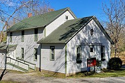
Historical information sign at the Bonnell–Westbrook wagon house on Clove Road
This page is based on this Wikipedia article Text is available under the CC BY-SA 4.0 license; additional terms may apply. Images, videos and audio are available under their respective licenses.