Deerfield is an unincorporated community within Upper Deerfield Township, Cumberland County, New Jersey, United States. The western and northeastern areas of the community are part of the Deerfield Street census-designated place for population statistical purposes.
Vauxhall is an unincorporated community located within Union Township in Union County, New Jersey, United States. Vauxhall borders Millburn, Maplewood and Springfield. The area is served as United States Postal Service ZIP Code 07088.
New Gretna is an unincorporated community located within Bass River Township in Burlington County, New Jersey, United States. The area is served as United States Postal Service ZIP Code 08224.

Mauricetown is an unincorporated community located within Commercial Township in Cumberland County, New Jersey.
Browntown is an unincorporated community located within Old Bridge Township in Middlesex County, New Jersey, United States. The area is served as United States Postal Service ZIP code 08857.
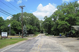
Birmingham is an unincorporated community located within Pemberton Township in Burlington County, New Jersey, United States. As of the 2010 United States Census, the ZIP Code Tabulation Area for ZIP Code 08011 had a population of 33. Though sparsely populated, it houses a post office and a Lanxess chemical facility.

Baptistown is an unincorporated community located within Kingwood Township, in Hunterdon County, New Jersey, United States. Baptistown is located on New Jersey Route 12, approximately three miles (4.8 km) east of Frenchtown. The township's municipal offices are located in Baptistown just north of the center of the community.
Greendell is an unincorporated community located within Green Township, in Sussex County, New Jersey, United States. Greendell is 4.2 miles (6.8 km) west of Andover. Greendell has a post office with ZIP code 07839.
Ironia is an unincorporated community located within Randolph Township, in Morris County, New Jersey, United States. Ironia is 5.4 miles (8.7 km) southwest of Dover. Ironia has a post office with ZIP code 07845.
Middleville is an unincorporated community located within Stillwater Township, in Sussex County, New Jersey, United States. Middleville is 5.8 miles (9.3 km) west of Newton. Middleville has a post office with ZIP code 07855.
Swartswood is an unincorporated community located on the border of Hampton and Stillwater townships in Sussex County, New Jersey, United States. Swartswood is 4.4 miles (7.1 km) west-northwest of Newton. Swartswood has a post office with ZIP code 07877.
Grenloch is an unincorporated community located within Washington Township, Gloucester County, New Jersey, United States. Grenloch is located along New Jersey Route 168 10.25 miles (16.50 km) south-southeast of Camden. Grenloch has a post office with ZIP code 08032.
Waterford Works is an unincorporated community located within Winslow Township in Camden County, New Jersey, United States. Waterford Works is 1.8 miles (2.9 km) east-southeast of Chesilhurst. Waterford Works has a post office with ZIP code 08089, which opened on February 13, 1838.

Cologne is an unincorporated community located within Galloway Township, in Atlantic County, New Jersey, United States. Cologne is located on U.S. Route 30, about 2.5 miles (4.0 km) southeast of Egg Harbor City. Cologne has a post office with ZIP code 08213.

Dividing Creek is an unincorporated community located within Downe Township in Cumberland County, New Jersey, United States.
Milmay is an unincorporated community and census-designated place (CDP) located mostly within Buena Vista Township, in Atlantic County, New Jersey, United States. Part of the CDP extends southwest into Maurice River Township in Cumberland County.
Newtonville is an unincorporated community in Buena Vista Township in Atlantic County, New Jersey, United States. Newtonville is located on a Conrail line 4.7 miles (7.6 km) east-northeast of Buena. Newtonville has a post office with ZIP code 08346.
Norma is an unincorporated community located within Pittsgrove Township in Salem County, New Jersey, United States. Norma is located at the junction of County Routes 540 and 638, west of Vineland. Norma has a post office with ZIP code 08347, which opened on June 29, 1888.
Allaire is an unincorporated community located within Wall Township in Monmouth County, New Jersey, United States. As of the 2010 United States Census, the ZIP Code Tabulation Area for ZIP Code 07727 had a population of 7,050.
Ewan is an unincorporated community located within Harrison Township, in Gloucester County, New Jersey, United States. The area is served by the United States Postal Service as ZIP code 08025.


