
Adams Township is a civil township of Houghton County in the U.S. state of Michigan. As of the 2020 census, the township population was 2,540.

Alta Lake State Park is a public recreation area located two miles (3.2 km) southwest of Pateros, Washington, at the northern end of 220-acre (89 ha) Alta Lake, in the mountainous northwest interior of the state. The 181-acre (73 ha) state park and adjacent lake lie beneath towering stone cliffs, formed by glaciation, that rise 1000 feet above the valley floor, and carry on up to the top of Old Goat Mountain which sits 4200 ft above the park. A two-mile-long (3 km) road leading to the park, Alta Lake Road, intersects State Route 153, which runs along the Methow River. The park is managed by the Washington State Parks and Recreation Commission.

The Chippewa River is a stream in Michigan, United States, that runs 91.8 miles (147.7 km) through the central Lower Peninsula. The Chippewa is a tributary of the Tittabawassee River and is thus part of the Saginaw River drainage basin. The river is named after the Chippewa people.
Cushing is an unincorporated community in Cushing Township, Morrison County, Minnesota, United States. The community is located along U.S. Highway 10 near Morrison County Road 5, Bear Road. Nearby places include Randall, Little Falls, and Motley.

Sandy Lick Creek is a tributary of Redbank Creek in northwest Pennsylvania in the United States.

Norton is an unincorporated community located within Union Township, in Hunterdon County, New Jersey. Norton is located on County Route 635, approximately 1.5 mi (2.4 km) northwest of Interstate 78. The village is included in the Van Syckel Corner District, which was added to the National Register of Historic Places in 1979.
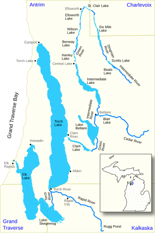
The Elk River Chain of Lakes Watershed, commonly known as the Chain of Lakes, is a 75-mile-long (121 km) waterway consisting of 14 lakes and connecting rivers in the northwestern section of the Lower Peninsula of the U.S. state of Michigan, which empty into Lake Michigan.

Odell Lake is located near Willamette Pass in the northwest corner of Klamath County, Oregon, United States. It is one of several lakes in the Cascade Range in Central Oregon, and lies within the Deschutes National Forest. It was named for Oregon Surveyor General William Holman Odell by Byron J. Pengra, in July 1865, while they were making a preliminary survey for the Oregon Central Military Road, which would later become Oregon Route 58. The lake fills a basin carved by a glacier, and the resulting terminal moraine confines the water along the lake's southeast shore.
Zoar is an unincorporated community located in Sussex County, Delaware, United States.
Wentworth Springs is a set of springs that was once the site of a settlement and a camping resort in El Dorado County, California. It was located 11.5 miles (19 km) west of Meeks Bay.

Snake Mountain is a mountain located along the border of North Carolina and Tennessee, east of the community of Zionville, in the southeastern United States. It is part of the Blue Ridge Mountains, and includes parts of Watauga County, North Carolina, and Johnson County, Tennessee. It has two peaks, the higher of which reaches an elevation of 5,564 feet (1,696 m). The lower peak, at 5,518 feet (1,682 m), is Johnson County's high point.
Springdale is an unincorporated community in Andover Township, in Sussex County, in the U.S. state of New Jersey.
Brighton is an unincorporated community located within Andover Township and Green Township in Sussex County, New Jersey, United States.
Pinkneyville is an unincorporated community located within Andover Township in Sussex County, in the U.S. state of New Jersey.
Leggo is a ghost town in Yalobusha County, Mississippi, United States.

Deep Lake is a 66-acre (27 ha) body of water lying eight miles (13 km) south of Olympia in Thurston County, Washington. It is 17 feet (5.2 m) deep at its deepest point and has a water volume of 771 acre-feet (951,000 m3). The lake drains into Black River by way of Beaver Creek and Scott Lake. Deep Lake is located in Section 3, Township 16N, Range 2W, Willamette. The lake is bordered on two sides by Millersylvania State Park. An RV resort camp occupies the lake's eastern shore. The lake's fish population includes stocked rainbow trout and naturally reproducing largemouth bass, bluegill, yellow perch, and pumpkinseed.

Millville is an unincorporated community located along River Road and Shimers Brook in Montague Township of Sussex County, New Jersey. The Montague Grange and other parts of the community are in the Delaware Water Gap National Recreation Area.


