
Chatsworth is an unincorporated community located within Woodland Township in Burlington County, New Jersey, United States. The area is served as United States Postal Service ZIP Code 08019. The New Jersey Central's Blue Comet passenger train was wrecked here in 1939. Chatsworth has been called "Capital of the Pine Barrens."

Thorofare is an unincorporated community and census-designated place (CDP) located within West Deptford Township in northwestern Gloucester County, situated in the South Jersey region of the U.S. state of New Jersey. The area is served as United States Postal Service ZIP Code 08086. As of the 2020 United States census, the CDP's population was 2,806. As of the 2000 census, the population of a different geographic entity containing Thorofare, namely ZIP Code Tabulation Area 08086, was 5,424.
Cookstown is an unincorporated community and census-designated place (CDP) located within New Hanover Township in Burlington County, in the U.S. state of New Jersey. Located near Fort Dix, the area is served as United States Postal Service ZIP Code 08511.
Newport is an unincorporated community and census-designated place (CDP) located within Downe Township in Cumberland County, in the U.S. state of New Jersey. The area is served as United States Postal Service ZIP Code 08345.
Kirkwood is an unincorporated community located within Voorhees Township in Camden County, in the U.S. state of New Jersey. Kirkwood once had a post office assigned United States Postal Service ZIP Code 08043. The ZIP Code has been reassigned to a post office named Voorhees that serves the entire township. Kirkwood is still a valid city name for mailing purposes.

Ledgewood is an unincorporated community and census-designated place (CDP) located within Roxbury Township in Morris County, in the U.S. state of New Jersey. It was historically known as Drakesville after Abraham Drake, originally from Piscataway, New Jersey, who operated a mill and tavern here in the mid 1700s. The community was located on the Morris Canal.

Hibernia is an unincorporated community and census-designated place (CDP) located along County Route 513 in Rockaway Township of Morris County, in the U.S. state of New Jersey. The area is served as United States Postal Service ZIP Code 07842. The community takes its name from Hibernia, the classical name for Ireland.
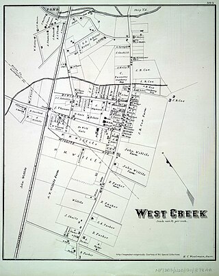
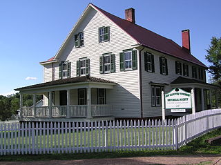
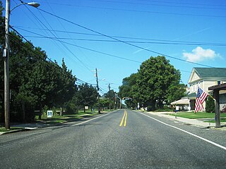
West Creek is an unincorporated community and hamlet located within Eagleswood Township in Ocean County, in the U.S. state of New Jersey.

Gillette is an unincorporated community and census-designated place (CDP) located within Long Hill Township in Morris County, in the U.S. state of New Jersey. The area is served as United States Postal Service ZIP Code 07933.
New Gretna is an unincorporated community and census-designated place (CDP) located within Bass River Township in Burlington County, in the U.S. state of New Jersey. The area is served as United States Postal Service ZIP Code 08224.

Mount Royal is an unincorporated community and census-designated place located within East Greenwich Township in Gloucester County, in the U.S. state of New Jersey. The area is served as United States Postal Service ZIP Code 08061.
West Berlin is an unincorporated community and census-designated place (CDP) located within Berlin Township in Camden County, in the U.S. state of New Jersey. The area is served as United States Postal Service ZIP Code 08091.
Macopin is an unincorporated community and census-designated place (CDP) located within West Milford in Passaic County, in the U.S. state of New Jersey. The area is served as United States Postal Service ZIP Code 07480.
Dorchester is an unincorporated community located within Maurice River Township, in Cumberland County, in the U.S. state of New Jersey. The area is served as United States Postal Service ZIP Code 08316.
Browntown is an unincorporated community located within Old Bridge Township in Middlesex County, in the U.S. state of New Jersey. The area is served as United States Postal Service ZIP Code 08857.

Jobstown is an unincorporated community and census-designated place (CDP) located within Springfield Township in Burlington County, in the U.S. state of New Jersey. The area is served as United States Postal Service ZIP Code 08041.

Harrisonville is an unincorporated community and census-designated place (CDP) located within South Harrison Township, in Gloucester County, in the U.S. state of New Jersey. The area is served as United States Postal Service ZIP Code 08039.

Ocean View is an unincorporated community and census-designated place (CDP) located within Dennis Township in Cape May County, in the U.S. state of New Jersey. The area is served as United States Postal Service ZIP Code 08230. The post office was established in 1872, with William Doolittle as the first postmaster.

Perrineville is an unincorporated community located within Millstone Township in Monmouth County, in the U.S. state of New Jersey. The area is served as United States Postal Service ZIP Code 08535.
Allaire is an unincorporated community located within Wall Township in Monmouth County, in the U.S. state of New Jersey. As of the 2010 United States Census, the ZIP Code Tabulation Area for ZIP Code 07727 had a population of 7,050.


