Millbrook, New Jersey | |
|---|---|
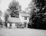
 George Trauger House | |
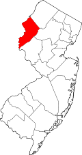
 Millbrook Location of Millbrook within Warren County. Inset: Location of Warren County in New Jersey.  Millbrook Millbrook (New Jersey)  Millbrook Millbrook (the United States) | |
| Coordinates: 41°04′24″N74°57′47″W / 41.07333°N 74.96306°W | |
| Country | |
| State | |
| County | Warren |
| Township | Hardwick |
| Named after | Van Campens Mill Brook |
| Elevation | 200 m (660 ft) |
| Time zone | UTC−05:00 (Eastern (EST)) |
| • Summer (DST) | UTC−04:00 (EDT) |
| GNIS feature ID | 878370 [1] |
Millbrook, also known as Millbrook Village, is an unincorporated community located along Old Mine Road within Hardwick Township, formerly Pahaquarry Township, in Warren County, in the U.S. state of New Jersey. [1] [2] It is named after the Mill Brook, now known as Van Campens Mill Brook, a tributary of the Delaware River. [3] [4] The area is now part of the Delaware Water Gap National Recreation Area. [5]