
Warren County is a county located in the U.S. state of New Jersey. As of the 2020 U.S. census, the county's population was 109,632, representing an increase of 940 (0.9%) from the 108,692 residents counted at the 2010 census. The county borders the Delaware River and Easton, Pennsylvania in the Lehigh Valley to its west, the New York City metropolitan area to its east, and The Poconos to its northwest. Warren County is the only county in New Jersey which is not part of the combined statistical areas of New York City or Philadelphia. The most populous place is Phillipsburg, with 14,950 residents at the time of the 2010 census while Hardwick Township had both the largest area 37.92 square miles (98.2 km2) and the fewest people with 1,696 residents. Its county seat is Belvidere.

Belvidere is a town in Warren County, New Jersey. As of the 2010 U.S. census, the town's population was 2,681, reflecting a decline of 90 (−3.2%) from the 2,771 counted in the 2000 census, which had in turn increased by 102 (+3.8%) from the 2,669 counted in the 1990 census. It is the county seat of Warren County.
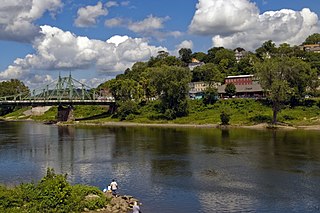
Phillipsburg is a town located along the Delaware River in Warren County, New Jersey. It is located across the river directly east from Easton, Pennsylvania. Phillipsburg is the most populous municipality in Warren County. As of 2010 U.S. census, the town's population was 14,950, reflecting a decline of 216 (−1.4%) from the 15,166 counted in the 2000 census, which had in turn declined by 591 (−3.8%) from the 15,757 counted in the 1990 census.
Pohatcong Township is a township in Warren County, New Jersey, United States. As of the 2010 United States Census, the township's population was 3,339, reflecting a decline of 77 (−2.3%) from the 3,416 counted in the 2000 Census, which had in turn declined by 175 (−4.9%) from the 3,591 counted in the 1990 Census.

Route 122 is a short, 2.42-mile-long (3.89 km) state highway in Warren County, New Jersey. The route runs from Warren County Route 678 and Pursel Street in Phillipsburg to an intersection with U.S. Route 22 (US 22) in Pohatcong Township. The route is a former alignment of US 22, designated in 1926, however, until 1993, the route was designated U.S. Route 22 Alternate. After 1993, the route was decommissioned and replaced by County Route 678 (CR 648) and Route 122.

The Lehigh and Hudson River Railway (L&HR) was the smallest of the six railroads that were merged into Conrail in 1976. It was a bridge line running northeast–southwest across northwestern New Jersey, connecting the line to the Poughkeepsie Bridge at Maybrook, New York with Easton, Pennsylvania, where it interchanged with various other companies.
The Warren Railroad was a railroad in Warren County, New Jersey, that served as part of the Delaware, Lackawanna and Western Railroad's mainline from 1856 to 1911.
The Belvidere-Delaware Railroad was a railroad running along the eastern shore of the Delaware River from Trenton, New Jersey north via Phillipsburg, New Jersey to the small village of Manunka Chunk, New Jersey. It became an important feeder line for the Lehigh Valley Railroad's join to the Central Railroad of New Jersey, which was constructed into Phillipsburg, NJ at about the same time. This connected Philadelphia and Trenton, NJ at one end of the shortline railroad to the rapidly growing lower Wyoming Valley region, and via the Morris Canal or the CNJ, a slow or fast connection to New York City ferries crossing New York Harbor from Jersey City, NJ. In 1871 the CNJ leased various railroads in Pennsylvania, most from the Lehigh Coal & Navigation Company allowing the CNJ to penetrate to the upper Wyoming Valley, over some stretches, competing directly with the Lehigh Valley Railroad and with the Lehigh Canal and the trunk road connection of the Belvidere Delaware Railroad to New York became less profitable since Philadelphia connected more easily to Northeastern Pennsylvania thereafter without needing a double-crossing of the Delaware River; a general revenue decline ensued, leading to the Pennsylvania Railroad acquiring the rights, where it served as part of the Pennsylvania Railroad (PRR) system, carrying mainly anthracite coal and iron ore from northeastern Pennsylvania to population centers along the coast.

The Belvidere & Delaware River Railway Company also known as Delaware River Railroad is a class III railroad in the United States. It was formed in 1995 when the Conrail Delaware Secondary line was purchased by the Black River Railroad System, which operates several railroad services in western New Jersey and eastern Pennsylvania. The Black River Railroad System also owns and operates the Black River & Western Railroad (BR&W). BR&W leases 10 miles of track to BDRV since 2004. Trackage purchased was a segment of the original Belvidere Delaware Railroad, later controlled by the Pennsylvania Railroad and ultimately Penn Central.
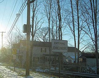
Johnsonburg is an unincorporated community and census-designated place (CDP) located within Frelinghuysen Township in Warren County, New Jersey, United States, that was created as part of the 2010 United States Census. As of the 2010 Census, the CDP's population was 101.
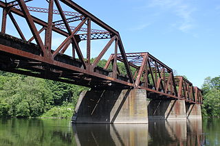
The Lackawanna Old Road was part of the original mainline of the Delaware, Lackawanna & Western Railroad (DL&W). Opened in 1856, it was for a half-century a part of the line connecting the states of New Jersey and Pennsylvania. In 1911, the DL&W cut 11 miles (18 km) off the route by opening the Lackawanna Cut-Off, which branched off from existing track at the new Port Morris Junction and Slateford Junction. The 39.6-mile (63.7 km) stretch of existing track between these junctions was relegated to secondary status and became known as the "Old Road".
Delaware River Drive was a state highway in the U.S. state of New Jersey.

Marksboro is an unincorporated community and census-designated place (CDP) located within Frelinghuysen Township in Warren County, New Jersey, United States, that was created as part of the 2010 United States Census, though settlement and naming of the community date back to before 1760. As of the 2010 Census, the CDP's population was 82.

Finesville is an unincorporated community and census-designated place (CDP) located within Pohatcong Township in Warren County, New Jersey, United States, that was defined as part of the 2010 United States Census. As of the 2010 Census, the CDP's population was 175.

Foul Rift is an unincorporated community and one-time ghost town located within White Township, in Warren County, New Jersey, United States. Foul Rift had been a cottage community located on the east bank of the Delaware River, 2 mi (3.2 km) south of Belvidere.
Warrington is an unincorporated community located within Knowlton Township in Warren County, New Jersey, United States.
Townsbury is an unincorporated community located within Liberty Township in Warren County, New Jersey, United States.
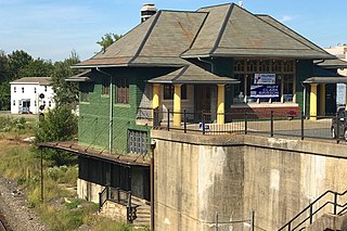
Phillipsburg Union Station is an inactive railroad station in Phillipsburg, New Jersey, United States, at 178 South Main Street. Opened in 1914, Union Station was built by the Delaware, Lackawanna & Western Railroad (DL&W) and shared with the Central Railroad of New Jersey (CNJ) and was situated where the lines merged before the bridge crossing the Delaware River. Designed by Frank J. Nies, the architect who produced many of DL&W stations now listed state and federal registers of historic places, the 2 1/2 story, 3 bay brick building is unusual example of a union station and a representation of early 20th century Prairie style architecture. The Phillipsburg Union Signal Tower, or PU Tower, is nearby.
Springtown is an unincorporated community located at the intersection of Springtown Road and the Pohatcong Creek in Pohatcong Township, Warren County, New Jersey. It was named after the many small springs in the valley.

Riegelsville is an unincorporated community located in Pohatcong Township of Warren County, New Jersey. It is connected to Riegelsville, Pennsylvania across the Delaware River by the Riegelsville Bridge. The community is by the confluence of the Musconetcong River with the Delaware River. The Riegelsville Company Town Historic District encompassing the community was listed in the New Jersey Register of Historic Places in 1998.


