
Warren County is a county located in the U.S. state of New Jersey. According to the 2020 census, the county was the state's 19th-most populous county, with a population of 109,632, its highest decennial count ever and an increase of 940 (+0.9%) from the 2010 census count of 108,692, which in turn reflected an increase of 6,255 (+6.1%) from 102,437 counted at the 2000 census. The county is part of the North Jersey region of the state.

Route 57 is a state highway located in Warren County in the U.S. state of New Jersey. It runs 21.10 mi (33.96 km) from an interchange with U.S. Route 22 (US 22) in Lopatcong Township to an intersection with Route 182 and County Route 517 (CR 517) in Hackettstown. The route passes through mostly rural areas of farmland and mountains in Warren County. It also passes through Washington, where Route 57 crosses Route 31. The route is designated a scenic byway, the Warren Heritage Scenic Byway, by the state of New Jersey due to the physical environments it passes through as well as from historical sites along the way such as the Morris Canal.

Phillipsburg is a town located along the Delaware River that is the most populous municipality in Warren County, in the U.S. state of New Jersey. It is part of the Allentown-Bethlehem-Easton, PA-NJ Metropolitan Statistical Area. As of the 2020 United States census, the town's population was 15,249, an increase of 299 (+2.0%) from the 2010 census count of 14,950, which in turn reflected a decline of 216 (−1.4%) from the 15,166 counted in the 2000 census.
Pohatcong Township is a township in Warren County, in the U.S. state of New Jersey. As of the 2020 United States census, the township's population was 3,241, a decrease of 98 (−2.9%) from the 2010 census count of 3,339, which in turn reflected a decline of 77 (−2.3%) from the 3,416 counted in the 2000 census.
Williams Township is a township in Northampton County, Pennsylvania. The township's population was 6,581 at the 2020 census. The township is part of the Lehigh Valley metropolitan area, which had a population of 861,899 and was the 68th-most populous metropolitan area in the U.S. as of the 2020 census.

Delaware is an unincorporated community and census-designated place (CDP) located along the Delaware River within Knowlton Township in Warren County, New Jersey. It was created as part of the 2010 United States Census. As of the 2010 Census, the CDP's population was 150. The area is served as United States Postal Service ZIP Code 07833.

Johnsonburg is an unincorporated community and census-designated place (CDP) located within Frelinghuysen Township in Warren County, in the U.S. state of New Jersey, that was created as part of the 2010 United States Census. As of the 2020 Census, the CDP's population was 381, up from 101 in the 2010 Census.

Asbury is an unincorporated community and census-designated place (CDP) located within Franklin Township in Warren County, in the U.S. state of New Jersey, that was created as part of the 2010 United States Census. As of the 2010 Census, the CDP's population was 273.

The Riegelsville Bridge is a suspension bridge crossing the Delaware River at Riegelsville, Pennsylvania, connecting it with Riegelsville, New Jersey, United States.
Prallsville is an unincorporated community located along New Jersey Route 29 by the border of Stockton and Delaware Township in Hunterdon County, New Jersey. The Delaware River and Wickecheoke Creek border the community. The Prallsville District was listed on the National Register of Historic Places in 1979.

Finesville is an unincorporated community and census-designated place (CDP) located within Pohatcong Township in Warren County, in the U.S. state of New Jersey. The CDP was defined as part of the 2010 United States Census. As of the 2010 Census, the CDP's population was 175.
Carpentersville is an unincorporated community located in Pohatcong Township in Warren County, in the U.S. state of New Jersey.

Headquarters is an unincorporated community located within the Amwell Valley of Delaware Township in Hunterdon County, New Jersey. The settlement is centered around the intersection of Zentek Road and County Route 604. It is about 3 miles (4.8 km) from Ringoes to the east and 1 mile (1.6 km) from Sergeantsville to the west. The Headquarters Historic District was listed on the state and national registers of historic places in 2011 and had its boundary increased in 2016.

Bowerstown is an unincorporated community in Washington Township, Warren County, New Jersey near the Morris Canal and the Pohatcong Creek. It was founded in 1829 by Jesse Vanetta and Michael B. Bowers with the building of an iron foundry. The Bowerstown Historic District, encompassing the village, was listed on the state and national registers of historic places in 1996.

Pleasant Valley is an unincorporated community located in Washington Township, Warren County, New Jersey, west of Washington, along the Pohatcong Creek. The hamlet was built around a mill on the creek during the mid-18th century. The Pleasant Valley Historic District, encompassing the village, is listed on the state and national registers of historic places.
Springtown is an unincorporated community located at the intersection of Springtown Road and the Pohatcong Creek in Pohatcong Township, Warren County, New Jersey. It was named after the many small springs in the valley.

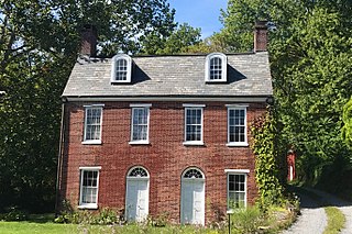
The George Hunt House is a historic building located southwest of Alpha at 135 Warren Glen Road in Pohatcong Township, Warren County, New Jersey. It was built c. 1825 near the confluence of the Musconetcong River with the Delaware River. The house was added to the National Register of Historic Places on September 12, 1979, for its significance in architecture.

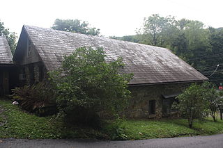
The Seigle Homestead is a historic house built c. 1793 and located along Riegelsville-Warren Glen Road in Finesville of Pohatcong Township, the only surviving two story log house in Warren County, New Jersey. It was added to the National Register of Historic Places on November 7, 1977 for its significance in architecture and social history.

Bevans, also known as Peters Valley, is an unincorporated community located at the intersection of Bevans Road, Walpack Road, and Kuhn Road in Sandyston Township of Sussex County, New Jersey. The village is now part of the Delaware Water Gap National Recreation Area. Both the Delaware River and the Old Mine Road are nearby.

Millville is an unincorporated community located along River Road and Shimers Brook in Montague Township of Sussex County, New Jersey. The Montague Grange and other parts of the community are in the Delaware Water Gap National Recreation Area.


