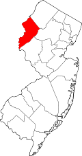
Location of Mansfield Township in Warren County highlighted in yellow (right). Inset map: Location of Warren County in New Jersey highlighted in black (left).
Census Bureau map of Mansfield Township, Warren County, New Jersey
What is now Mansfield Township was formed on May 30, 1754, as Mansfield-Woodhouse Township from portions of Greenwich Township, while the area was still part of Sussex County, and was incorporated as Mansfield Township on February 21, 1798, as one of New Jersey's initial group of 104 townships by an act of the New Jersey Legislature. The township became part of the newly formed Warren County on November 20, 1824. Portions of the township were taken to form Franklin Township (April 8, 1839) and Washington Township (April 9, 1849).[21] The township was named after William Murray, 1st Earl of Mansfield.[3]
Geography
According to the United States Census Bureau, the township had a total area of 29.69 square miles (76.90km2), including 29.59 square miles (76.63km2) of land and 0.11 square miles (0.27km2) of water (0.35%).[1][2]
Other unincorporated communities, localities and place names located partially or completely within the township include Karrsville, Mount Bethel, Penwell, Rockport and Stephensburg.[28]
Of the 2,972 households, 31.4% had children under the age of 18; 51.8% were married couples living together; 10.7% had a female householder with no husband present and 32.7% were non-families. Of all households, 25.5% were made up of individuals and 7.7% had someone living alone who was 65 years of age or older. The average household size was 2.54 and the average family size was 3.08.[18]
22.9% of the population were under the age of 18, 7.9% from 18 to 24, 26.8% from 25 to 44, 29.7% from 45 to 64, and 12.8% who were 65 years of age or older. The median age was 40.7 years. For every 100 females, the population had 94.6 males. For every 100 females ages 18 and older there were 93.4 males.[18]
The Census Bureau's 2006–2010 American Community Survey showed that (in 2010 inflation-adjusted dollars) median household income was $74,063 (with a margin of error of +/− $8,316) and the median family income was $87,434 (+/− $8,330). Males had a median income of $56,567 (+/− $5,612) versus $41,583 (+/− $1,597) for females. The per capita income for the borough was $32,259 (+/− $2,751). About 5.1% of families and 6.3% of the population were below the poverty line, including 8.3% of those under age 18 and 3.9% of those age 65 or over.[42]
2000 census
As of the 2000 United States census[15] there were 6,653 people, 2,334 households, and 1,750 families residing in the township. The population density was 222.3 inhabitants per square mile (85.8/km2). There were 2,415 housing units at an average density of 80.7 per square mile (31.2/km2). The racial makeup of the township was 90.91% White, 4.51% African American, 0.24% Native American, 1.22% Asian, 1.59% from other races, and 1.53% from two or more races. Hispanic or Latino of any race were 4.37% of the population.[40][41]
There were 2,334 households, out of which 39.0% had children under the age of 18 living with them, 61.3% were married couples living together, 9.0% had a female householder with no husband present, and 25.0% were non-families. 18.9% of all households were made up of individuals, and 6.3% had someone living alone who was 65 years of age or older. The average household size was 2.76 and the average family size was 3.18.[40][41]
In the ownship the population was spread out, with 27.0% under the age of 18, 6.2% from 18 to 24, 32.4% from 25 to 44, 22.7% from 45 to 64, and 11.7% who were 65 years of age or older. The median age was 37 years. For every 100 females, there were 94.8 males. For every 100 females age 18 and over, there were 91.2 males.[40][41]
The median income for a household in the township was $61,763, and the median income for a family was $76,102. Males had a median income of $50,295 versus $35,737 for females. The per capita income for the township was $26,277. About 2.7% of families and 3.9% of the population were below the poverty line, including 3.9% of those under age 18 and 5.9% of those age 65 or over.[40][41]
Government
Local government
Mansfield Township is governed under the Township form of New Jersey municipal government, one of 141 municipalities (of the 564) statewide that use this form, the second-most commonly used form of government in the state.[43] The Township Committee is comprised of five members, who are elected directly by the voters at-large in partisan elections to serve three-year terms of office on a staggered basis, with either one or two seats coming up for election each year as part of the November general election in a three-year cycle.[4][44] At an annual reorganization meeting conducted during the first week of January, the Township Committee selects one of its members to serve as Mayor and another to serve as Deputy Mayor.
As of 2022[update], members of the Mansfield Township Committee are Mayor Joseph E. Watters (R, term on committee ends December 31, 2024; term as mayor ends 2022), Deputy mayor Glen McGuinness (R, term on committee and as deputy mayor ends 2022; elected to serve an unexpired term), Desiree Mora Dillon (R, 2022) and Joseph D. Farino (R, 2023) and Ronald Hayes (R, 2023).[5][45][46][47][48]
In January 2020, Tony Cardell, who had been elected as a Republican in November 2019, announced that he would not be taking office for the seat expiring in December 2022.[49] Glen McGuinness was elected in November 2021 to fill the balance of the term of office.[46]
Federal, state, and county representation
Mansfield Township is located in the 7th Congressional District[50] and is part of New Jersey's 23rd state legislative district.[51][52][53]
Warren County is governed by a three-member Board of County Commissioners, who are chosen at-large on a staggered basis in partisan elections with one seat coming up for election each year as part of the November general election. At an annual reorganization meeting held in the beginning of January, the board selects one of its members to serve as Commissioner Director and other as Deputy Director.[57] As of 2025[update], Warren County's Commissioners are:
As of March 2011, there were a total of 4,443 registered voters in Mansfield Township, of which 779 (17.5% vs. 21.5% countywide) were registered as Democrats, 1,784 (40.2% vs. 35.3%) were registered as Republicans and 1,877 (42.2% vs. 43.1%) were registered as Unaffiliated. There were three voters registered as Libertarians or Greens.[69] Among the township's 2010 Census population, 57.5% (vs. 62.3% in Warren County) were registered to vote, including 74.6% of those ages 18 and over (vs. 81.5% countywide).[69][70]
United States Gubernatorial election results for Mansfield Township[71]
In the 2012 presidential election, Republican Mitt Romney received 1,789 votes (57.6% vs. 56.0% countywide), ahead of Democrat Barack Obama with 1,232 votes (39.7% vs. 40.8%) and other candidates with 45 votes (1.4% vs. 1.7%), among the 3,105 ballots cast by the township's 4,596 registered voters, for a turnout of 67.6% (vs. 66.7% in Warren County).[72][73] In the 2008 presidential election, Republican John McCain received 1,925 votes (57.5% vs. 55.2% countywide), ahead of Democrat Barack Obama with 1,328 votes (39.7% vs. 41.4%) and other candidates with 50 votes (1.5% vs. 1.6%), among the 3,349 ballots cast by the township's 4,504 registered voters, for a turnout of 74.4% (vs. 73.4% in Warren County).[74] In the 2004 presidential election, Republican George W. Bush received 2,043 votes (64.6% vs. 61.0% countywide), ahead of Democrat John Kerry with 1,076 votes (34.0% vs. 37.2%) and other candidates with 34 votes (1.1% vs. 1.3%), among the 3,163 ballots cast by the township's 4,227 registered voters, for a turnout of 74.8% (vs. 76.3% in the whole county).[75]
United States presidential election results for Mansfield Township[76]
In the 2013 gubernatorial election, Republican Chris Christie received 74.1% of the vote (1,251 cast), ahead of Democrat Barbara Buono with 23.7% (401 votes), and other candidates with 2.2% (37 votes), among the 1,715 ballots cast by the township's 4,683 registered voters (26 ballots were spoiled), for a turnout of 36.6%.[77][78] In the 2009 gubernatorial election, Republican Chris Christie received 1,415 votes (66.5% vs. 61.3% countywide), ahead of Democrat Jon Corzine with 482 votes (22.6% vs. 25.7%), Independent Chris Daggett with 171 votes (8.0% vs. 9.8%) and other candidates with 29 votes (1.4% vs. 1.5%), among the 2,129 ballots cast by the township's 4,360 registered voters, yielding a 48.8% turnout (vs. 49.6% in the county).[79]
United States Senate election results for Mansfield Township1[80]
Public school students in seventh through twelfth grades attend the schools of the Warren Hills Regional School District, which also serves students from the municipalities of Franklin Township, Washington Borough and Washington Township, along with those from Oxford Township (for 9–12 only, attending on a tuition basis).[87][88][89] Schools in the district (with 2023–24 enrollment data from the National Center for Education Statistics[90]) are Warren Hills Regional Middle School[91] with 480 students in grades 7–8 (located in Washington Borough) and Warren Hills Regional High School[92] with 1,066 students in grades 9–12 (located in Washington Township).[83][93][94] Seats on the high school district's nine-member board of education are allocated to based on the population of the constituent municipalities, with three seats assigned to Mansfield Township.[95] Oxford Township does not have representation on the board since it sends its students as part of a sending/receiving relationship.[96]
As of May2010[update], the township had a total of 72.40 miles (116.52km) of roadways, of which 46.85 miles (75.40km) were maintained by the municipality, 16.79 miles (27.02km) by Warren County and 8.76 miles (14.10km) by the New Jersey Department of Transportation.[100]
The only major roads that pass through are Route 31 which passes through briefly in the west[101] and Route 57 runs for 7.9 miles (12.7km) in the southern part.[102]
A small general aviation airport, named Hackettstown Airport and holding the official database designation of (FAALID: N05) is in Mansfield Township, only a few hundred yards from the municipal border with Hackettstown.[104]
12Municipal Government, Mansfield Township. Accessed May 30, 2024. "Under the current township government laws, the Township Committee remains the backbone of the municipality’s government. Voters elect, at-large, the Township Committee comprising five members. The elections are partisan and the committee members serve staggered three-year terms. The Township Committee elects the mayor for a one-year term."
↑Reorganization Meeting Minutes for January 1, 2020, Township of Mansfield. Accessed February 26, 2020. "Ms. Hrebenak stated that a letter of resignation was received from Mr. Tony Cardell, this causes a vacancy on the Township Committee and will be referred to the Municipal County Committee."
↑Kean, Thomas. "Congressman Thomas Kean Jr". United States House of Representatives. United States House of Representatives. Retrieved February 15, 2025.
↑Governmental Structure, Warren County, New Jersey. Accessed February 22, 2022. "Warren County operates under the County Commissioner form of county government. The Board of County Commissioners consists of three Commissioners each elected at large for staggered terms of three years. The Commissioner Director is chosen by the full board at the board's annual reorganization meeting in January. The Commissioners supervise, direct, and administer all county services and functions through the various departments, autonomous boards, agencies, and commissions. Reporting to the Board of County Commissioners is an appointed County Administrator."
↑Jason J. Sarnoski, Warren County, New Jersey. Accessed February 22, 2022.
↑Lori Ciesla, Warren County, New Jersey. Accessed February 22, 2022.
↑James R. Kern III, Warren County, New Jersey. Accessed February 22, 2022.
↑Mansfield Township Board of Education District Policy 0110 - Identification, Mansfield Township School District. Accessed April 28, 2024. "Purpose: The Board of Education exists for the purpose of providing a thorough and efficient system of free public education in grades Pre-Kindergarten through six in the Mansfield Township School District. Composition: The Mansfield Township School District is comprised of all the area within the municipal boundaries of Mansfield Township."
↑Warren Hills Regional Board of Education District Policy 0110 - Identification, Warren Hills Regional School District, revised April 9, 2019. Accessed August 19, 2025. "Purpose: The Board of Education exists for the purpose of providing a thorough and efficient system of free public education in grades 7 through 12 in the Warren Hills Regional School District. Composition: The Warren Hills Regional School District is comprised of all the area within the municipal boundaries of Franklin Township, Mansfield Township, Washington Borough, Washington Township in the County of Warren."
↑Warren Hills Regional School District 2014 Report Card Narrative, New Jersey Department of Education. Accessed June 6, 2020. "At Warren Hills Regional, we provide our students with a strong academic foundation. From the receiving districts of Franklin Township, Mansfield Township, Oxford (high school tuition students), Washington Borough and Washington Township, students progress along the academic continuum led by a faculty committed to planning and implementing a variety of instructional strategies and activities that facilitate the preparation of our students for the challenge of mastering the New Jersey Core Curriculum Content Standards and the Common Core State Standards."
↑Our History, Warren Hills Regional School District. Accessed August 18, 2025. "The Warren Hills Regional School District services students from Franklin Township, Mansfield Township, Washington Borough and Washington Township. Oxford Township currently sends its high school students to the Warren Hills Regional High School on a tuition basis."
↑Warren Hills Regional Board of Education District Policy 0141 - Board Member Number and Term, Warren Hills Regional School District, revised May 14, 2019. Accessed August 19, 2025. "The Board of Education shall consist of nine [9] members as follows: Franklin Township - 1 member; Mansfield Township - 3 members; Washington Borough - 2 members; Washington Township - 3 members. The term of a Board member shall be three [3] years."
↑Board of Education, Warren Hills Regional School District. Accessed August 19, 2025.
↑F.A.Q., Ridge and Valley Charter School. Accessed January 5, 2017. "Enrollment is open, on a space available basis, to all K-8 students residing in N.J. with priority given to students residing in the districts of Blairstown, Hardwick, Knowlton, Frelinghuysen, and North Warren Regional School."
↑Staff. "Mansfield Township was the scene of one of the worst railroad disasters 85 years ago", The Express-Times, June 16, 2010. Accessed June 10, 2013. "Eight-five years ago today, a stretch of the Lackawanna Railway in Mansfield Township became the scene of one of the worst railway disasters in the nation's history. On June 16, 1925, 50 people died when a Hoboken-bound steam locomotive derailed near the Rockport Pheasant Farm when the front wheels hit debris from a heavy rain storm and jumped the track at approximately 3 a.m."
↑Charlton, Art; and Sterling, Guy. "A legendary wartime hero started out as Jersey boy", The Star-Ledger, April 9, 1996. Accessed March 8, 2025, via Newspapers.com. The 1928 yearbook of Hackettstown High School predicted John D. Bulkeley would be a sailor, but that underestimated the kind of sailor he became: a highly decorated wartime hero who rose to the rank of vice admiral.... "Dale said he moved to a farm in Mansfield, Warren County, as a young boy. There he attended a one-room elementary school in Beattystown."
↑"Alumni 1950:", p. 37, Catalyst Magazine of the University of California, Berkeley, June 16, 2015. Accessed March 30, 2023. "We have learned from his daughter, Marilyn Barber, that John Eugene Kunzler (Ph.D. Chem) passed away on Najuary 11, 2006, after a brief battle with cancer... He had made his home in Port Murray, NJ."
This page is based on this Wikipedia article Text is available under the CC BY-SA 4.0 license; additional terms may apply. Images, videos and audio are available under their respective licenses.