Deer Lick, Oklahoma

Last updated

Deer Lick, Oklahoma
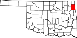
USA Oklahoma location map.svg
Red pog.svg
Deer Lick
Location within the state of Oklahoma
Coordinates: 36°27′34″N94°44′49″W / 36.45944°N 94.74694°W / 36.45944; -94.74694
Country United States
State Oklahoma
County Delaware
Area
[1]
  Total0.95 sq mi (2.47 km2)
  Land0.95 sq mi (2.47 km2)
  Water0.00 sq mi (0.00 km2)
Elevation
[2]
1,070 ft (330 m)
Population
 (2020)
  Total34
  Density35.68/sq mi (13.77/km2)
Time zone UTC-6 (Central (CST))
  Summer (DST) UTC-5 (CST)
FIPS code 40-19665
GNIS feature ID2584377 [2]

Deer Lick is an unincorporated community and census-designated place (CDP) in Delaware County, Oklahoma, United States. The population was 46 at the 2010 census. [3]

Contents

Geography

Deer Lick is located in central Delaware County, 4 miles (6 km) northeast of Jay, the county seat. According to the United States Census Bureau, the Deer Lick CDP has a total area of 0.95 square miles (2.47 km2), all land. [3]

Demographics

Historical population
CensusPop.Note
2020 34
U.S. Decennial Census [4]

Related Research Articles

Bull Hollow is an unincorporated community and census-designated place (CDP) in Delaware County, Oklahoma, United States. The population was 67 at the 2010 census.

Cayuga Springs is an unincorporated community and census-designated place (CDP) in Delaware County, Oklahoma, United States. The population was 140 at the 2010 census, a 33.3 percent increase over the figure of 105 recorded in 2000.

Copeland is an unincorporated community and census-designated place (CDP) in Delaware County, Oklahoma, United States. The population was 1,629 at the 2010 census, a 12.5 percent increase from the figure of 1,448 recorded in 2000. Founded as a railroad community, it was named for local resident D.R. Copeland.

<span class="mw-page-title-main">Dennis, Oklahoma</span> Census-designated place in Oklahoma, United States

Dennis is an unincorporated community and census-designated place (CDP) in Delaware County, Oklahoma, near Grand Lake. The population was 195 at the 2010 census. The Dennis Post Office existed from March 25, 1914, until January 31, 1956. It is said to be named for a local resident, Peter Dennis.

<span class="mw-page-title-main">Dodge, Oklahoma</span> Census-designated place in Oklahoma, United States

Dodge is an unincorporated community and census-designated place (CDP) in Delaware County, Oklahoma, United States. The population was 115 at the 2010 census, up from the figure of 96 recorded in 2000.

Dripping Springs is an unincorporated community and census-designated place (CDP) in Delaware County, Oklahoma, United States. The population was 50 at the 2010 census, up from the figure of 41 recorded in 2000.

Flint Creek is an unincorporated area and census-designated place (CDP) in Delaware County, Oklahoma, United States. The population was 732 at the 2010 census, up from 580 in 2000.

<span class="mw-page-title-main">Leach, Oklahoma</span> Census-designated place in Oklahoma, United States

Leach is an unincorporated community and census-designated place (CDP) in southwestern Delaware County, Oklahoma, United States, along U.S. Route 412 and 412 Alternate. The population was 237 at the 2010 census.

New Eucha is a census-designated place (CDP) in Delaware County, Oklahoma, United States. The population was 405 at the 2010 census, up from the figure of 300 recorded in 2000.

Old Eucha is a census-designated place (CDP) in Delaware County, Oklahoma, United States. The population was 52 at the 2010 census.

Rocky Ford is a census-designated place (CDP) in Delaware and Cherokee counties, Oklahoma, United States. The population was 283 as of the 2020 Census, a whopping 464% increase over the population of 61 reported at the 2010 census.

Sycamore is a census-designated place (CDP) in Delaware County, Oklahoma, United States. The population was 177 at the 2010 census.

Tagg Flats is a census-designated place (CDP) in Delaware County, Oklahoma, United States. The population was 13 at the 2010 census.

<span class="mw-page-title-main">Twin Oaks, Oklahoma</span> Census-designated place in Oklahoma, United States

Twin Oaks is an unincorporated community and census-designated place (CDP) in Delaware County, Oklahoma, United States. The population was 198 at the 2010 census. A tornado hit the town on March 12, 2006, destroying 42 homes and injuring 8 people in Delaware County.

Kenwood is an unincorporated community and census-designated place (CDP) in Delaware and Mayes counties, Oklahoma, United States. As of the 2010 census it had a population of 1,224.

Flat Lick is an unincorporated community and census-designated place (CDP) in Knox County, Kentucky, United States. As of the 2010 census, the population was 960.

Butler is an unincorporated community and census-designated place (CDP) in Delaware County, Oklahoma, United States. The population was 117 at the 2010 census.

Drowning Creek is an unincorporated community and census-designated place (CDP) in Delaware County, Oklahoma, United States. The population was 155 at the 2010 census.

Indianola is an unincorporated area and census-designated place (CDP) in Delaware County, Oklahoma, United States. The population was 48 at the 2010 census.

White Water is a census-designated place (CDP) in Delaware County, Oklahoma, United States. The population was 80 at the 2010 census.

References

  1. "ArcGIS REST Services Directory". United States Census Bureau. Retrieved September 20, 2022.
  2. 1 2 U.S. Geological Survey Geographic Names Information System: Deer Lick, Oklahoma
  3. 1 2 "Geographic Identifiers: 2010 Demographic Profile Data (G001): Deer Lick CDP, Oklahoma". U.S. Census Bureau, American Factfinder. Archived from the original on February 13, 2020. Retrieved December 9, 2015.
  4. "Census of Population and Housing". Census.gov. Retrieved June 4, 2016.