Deer Lick, Oklahoma

Last updated

Deer Lick, Oklahoma
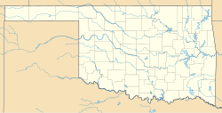
USA Oklahoma location map.svg
Red pog.svg
Deer Lick
Location within the state of Oklahoma
Coordinates: 36°27′34″N94°44′49″W / 36.45944°N 94.74694°W / 36.45944; -94.74694
Country United States
State Oklahoma
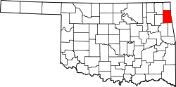
County Delaware
Area
[1]
 • Total
0.95 sq mi (2.47 km2)
 • Land0.95 sq mi (2.47 km2)
 • Water0 sq mi (0.00 km2)
Elevation
[2]
1,070 ft (330 m)
Population
 (2020)
 • Total
34
 • Density35.7/sq mi (13.77/km2)
Time zone UTC-6 (Central (CST))
 • Summer (DST) UTC-5 (CST)
FIPS code 40-19665
GNIS feature ID2584377 [2]

Deer Lick is an unincorporated community and census-designated place (CDP) in Delaware County, Oklahoma, United States. The population was 46 at the 2010 census. [3]
Contents

Geography

Deer Lick is located in central Delaware County, 4 miles (6 km) northeast of Jay, the county seat. According to the United States Census Bureau, the Deer Lick CDP has a total area of 0.95 square miles (2.47 km2), all land. [3]

Demographics

Historical population
CensusPop.Note%±
2020 34—
U.S. Decennial Census [4]

Education

It is in the Jay Public Schools school district. [5]

References

  1. ↑ "ArcGIS REST Services Directory". United States Census Bureau. Retrieved September 20, 2022.
  2. 1 2 U.S. Geological Survey Geographic Names Information System: Deer Lick, Oklahoma
  3. 1 2 "Geographic Identifiers: 2010 Demographic Profile Data (G001): Deer Lick CDP, Oklahoma". U.S. Census Bureau, American Factfinder. Archived from the original on February 13, 2020. Retrieved December 9, 2015.
  4. ↑ "Census of Population and Housing". Census.gov. Retrieved June 4, 2016.
  5. ↑ Geography Division. 2020 CENSUS - SCHOOL DISTRICT REFERENCE MAP: Delaware County, OK (PDF) (Map). U.S. Census Bureau . Retrieved April 4, 2025. - Text list