
Nanded is a city in Maharashtra state, India. It is the tenth largest city in the state and the seventy-ninth most populous city in India. It is the second largest city in Marathwada region. It is the district headquarters of Nanded district.

Adilabad is a city which serves as the headquarters of Adilabad district, in the Indian state of Telangana. Telugu is the native language of Adilabad. Adilabad is famous for its rich cultivation of cotton. Hence, Adilabad is also referred as "White Gold City". It is located about 304 kilometres (189 mi) north of the state capital, Hyderabad, 150 kilometres (93 mi) from Nizamabad and 196 kilometres (122 mi) from Nagpur. Adilabad is called as the "Gateway to South India".

Osmanabad District is an administrative district in the Marathwada region in the Indian state of Maharashtra. The district headquarter is located at Osmanabad. The District of Osmanabad derives its name from the last ruler of Hyderabad, the 7th Nizam, Mir Osman Ali Khan, of which the region was a part till 1947. This region was earlier part of The Hyderabad State until Independence.This primarily rural district occupies an area of 7,569 km2 (2,922 sq mi) of which 241.4 km2 (93.2 sq mi) is urban and has a population of 1,657,576 of which 16.96% were urban.
Nanded district is a district of Maharashtra state in central India. The city of Nanded is the district headquarters.
Zaheerabad or Zahirabad, is an industrial city and Municipal Council in Sangareddy district of the Indian state of Telangana.
Tuljapur is a town with a municipal council in Dharashiv district in the Indian state of Maharashtra. It is the administrative seat of Tuljapur taluka.
Udgir, is second largest city and municipal council in Latur district of the Indian state of Maharashtra. It is located in the Marathwada division of the state. The city is located very close to the borders of Karnataka and Telangana states. Udgir is home to the historical Udgir Fort. The town and nearby villages rely mainly on agriculture, which serves as a major source of income for the population.

Basara is a census town in Nirmal district in the state of Telangana, India. It is located about 208 kilometres (129 mi) north of the state capital Hyderabad, 34 kilometres (21 mi) from Nizamabad and 73 kilometres (45 mi) from the district headquarters Nirmal.

Bhainsa is a town in Nirmal district of the Indian state of Telangana. It is the headquarters of Bhainsa mandal and Bhainsa revenue division. It is bordered with Bhokar Thaluka, Nanded Jilla, Maharashtra State on west and Nizamabad district on South. Bhainsa is located at 19.1000°N 77.9667°E. It has an average elevation of 363 meters (1194 feet).

Dharmabad is a town and a municipal council in Nanded district in the state of Maharashtra, India. It is located near the state border with Telangana. Dharmabad has an average elevation of 359 metres (1,178 ft). It is connected by railway. An industrial training institute was established in the town in 1977.
Gadhinglaj ([ɡəɖᵊɦiŋɡləd͡z]) is a city in India in the Kolhapur district in the southwest corner of the state of Maharashtra, India. It is located on the banks of the river Hiranyakeshi. It is the Taluka (Tehsil) headquarters of Gadhinglaj Taluka and a subdivision headquarters of the Gadhinglaj Subdivision of the Kolhapur District. It is governed by a municipal council. The rapidly growing city is the third largest in the Kolhapur District, with population of more than 50,000. Places to visit like Samagad fort, temples and beautiful weather. Info. By Vinay Gawali.

Gangakhed is a city located on banks of Godavari River and a municipal council in Parbhani district in the state of Maharashtra, India. It is also known as Dakshin Kashi. It is also the second largest city In Parbhani District.

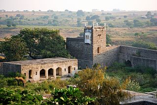
Kandhar is a town and a municipal council in Nanded district in the Indian state of Maharashtra. It lies near the western shore of Manyad Reservoir. Kandhar was famous as a major Jain centre in the Rashtrakuta kingdom, having Malkhed or Manyakheta as his capital. A huge statue of Kshetrapala is found near the bhuikot; the statue is broken but from the toenail that survives, its height is estimated to be more than 50 feet. Presently, there is an old Digambar Jain Temple in Kandhar which is awaiting for its renovation. Kandhar is also famous for Kandhar Fort.
Nipani is one of the famous village, taluk in the Belgaum district in the state of Karnataka, India. It is an important agricultural and commercial trade and education centre in the district. Nipani and its surrounding villages are known for growing high-quality tobacco, which is rolled into beedis.
Purna is a town with a municipal council in Parbhani district in the Indian state of Maharashtra.
Umarkhed is a Municipal council in Yavatmal district of Indian State of Maharashtra.

Aundha Naganath is a town in the Aundha Nagnath subdivision of Hingoli district. It lies in the Marathwada region of the Indian state of Maharashtra. The town is known for the Aundha Nagnath Temple, it is the 8th Jyotirling out of 12 which is dedicated to Shiva. The famous tourist spot along with the Temple includes the beautiful Garden and the Reserved Forest Region on the outskirts of the town.
Naigaon is a town and taluka in Nanded district of Maharashtra state in India. Naigaon (Bz.) is located 41.2 km south of the district headquarters city of Nanded and 60 km west from neighboring city of Nizamabad in Telangana State. Naigaon lies on MSH - 6. It is approximately 600 km from the State capital Mumbai. It is the Center of Naigaon Taluka. Naigaon is one of the rapidly growing towns in the Nanded District. The economy is primarily based on agriculture and related business.
The Hadgaon taluka or Hadgaon tehsil is a taluka in the Nanded district of the Indian state of Maharashtra. This tehsil includes one municipal council, Hadgaon, and 154 villages.
Nirmal district is a district located in the northern region of the Indian state of Telangana. The district headquarters is located in the town of Nirmal. It borders the Telangana districts of Adilabad, Nizamabad, Mancherial, Asifabad, Jagtial districts as well as Nanded district of the state Maharashtra.
