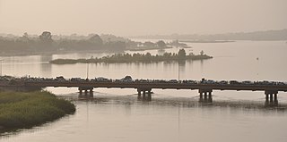
The Niger River is the principal river of West Africa, extending about 4,180 km (2,600 mi). Its drainage basin is 2,117,700 km2 (817,600 sq mi) in area. Its source is in the Guinea Highlands in southeastern Guinea. It runs in a crescent through Mali, Niger, on the border with Benin and then through Nigeria, discharging through a massive delta, known as the Niger Delta, into the Gulf of Guinea in the Atlantic Ocean. The Niger is the third-longest river in Africa, exceeded only by the Nile and the Congo River. Its main tributary is the Benue River.

The Great Artesian Basin (GAB), located in Australia, is the largest and deepest artesian basin in the world, stretching over 1,700,000 square kilometres (660,000 sq mi), with measured water temperatures ranging from 30–100 °C (86–212 °F). The basin provides the only source of fresh water through much of inland Australia.

The Continental Divide of the Americas is the principal, and largely mountainous, hydrological divide of the Americas. The Continental Divide extends from the Bering Strait to the Strait of Magellan, and separates the watersheds that drain into the Pacific Ocean from those river systems that drain into the Atlantic Ocean and, along the northernmost reaches of the Divide, those river systems that drain into the Arctic Ocean and Hudson Bay.

A drainage basin is any area of land where precipitation collects and drains off into a common outlet, such as into a river, bay, or other body of water. The drainage basin includes all the surface water from rain runoff, snowmelt, hail, sleet and nearby streams that run downslope towards the shared outlet, as well as the groundwater underneath the earth's surface. Drainage basins connect into other drainage basins at lower elevations in a hierarchical pattern, with smaller sub-drainage basins, which in turn drain into another common outlet.

Great Basin National Park is an American national park located in White Pine County in east-central Nevada, near the Utah border, established in 1986. The park is most commonly entered by way of Nevada State Route 488, which is connected to U.S. Routes 6 and 50 by Nevada State Route 487 via the small town of Baker, the closest settlement.

Lake Bonneville was the largest Late Pleistocene paleolake in the Great Basin of western North America. The Western Interior Seaway preceded Lake Bonneville. Lake Bonneville was a pluvial lake that formed in response to an increase in precipitation and a decrease in evaporation as a result of cooler temperatures. Lake Bonneville covered much of what is now western Utah and at its highest level extended into present-day Idaho and Nevada. Many other hydrographically closed basins in the Great Basin contained expanded lakes during the Late Pleistocene, including Lake Lahontan in northwestern Nevada.

The Great Basin is the largest area of contiguous endorheic watersheds in North America. It spans nearly all of Nevada, much of Oregon and Utah, and portions of California, Idaho, Wyoming, and Baja California, Mexico. It is noted for both its arid climate and the basin and range topography that varies from the North American low point at Badwater Basin in Death Valley to the highest point of the contiguous United States, less than 100 miles (160 km) away at the summit of Mount Whitney. The region spans several physiographic divisions, biomes, ecoregions, and deserts.

The Basin and Range Province is a vast physiographic region covering much of the inland Western United States and northwestern Mexico. It is defined by unique basin and range topography, characterized by abrupt changes in elevation, alternating between narrow faulted mountain chains and flat arid valleys or basins. The physiography of the province is the result of tectonic extension that began around 17 million years ago in the early Miocene epoch.

An endorheic basin is a drainage basin that normally retains water and allows no outflow to other external bodies of water, such as rivers or oceans, but drainage converges instead into lakes or swamps, permanent or seasonal, that equilibrate through evaporation. They are also called closed or terminal basins or internal drainage systems or basins. Endorheic regions contrast with exorheic regions. Endorheic water bodies include some of the largest lakes in the world, such as the Caspian Sea, the world's largest inland body of water.

The Great Basin Desert is part of the Great Basin between the Sierra Nevada and the Wasatch Range. The desert is a geographical region that largely overlaps the Great Basin shrub steppe defined by the World Wildlife Fund, and the Central Basin and Range ecoregion defined by the U.S. Environmental Protection Agency and United States Geological Survey. It is a temperate desert with hot, dry summers and snowy winters. The desert spans a large part of the state of Nevada, and extends into western Utah, eastern California, and Idaho. The desert is one of the four biologically defined deserts in North America, in addition to the Mojave, Sonoran, and Chihuahuan Deserts.

Regent's Canal is a canal across an area just north of central London, England. It provides a link from the Paddington Arm of the Grand Union Canal, 550 yards (500 m) north-west of Paddington Basin in the west, to the Limehouse Basin and the River Thames in east London. The canal is 8.6 miles (13.8 km) long.

The African Great Lakes are a series of lakes constituting the part of the Rift Valley lakes in and around the East African Rift. They include Lake Victoria, the second-largest fresh water lake in the world by area, Lake Tanganyika, the world's second-largest freshwater lake by volume and depth, and Lake Malawi, the world's eighth-largest fresh water lake by area. Collectively, they contain 31,000 km3 of water, which is more than either Lake Baikal or the North American Great Lakes. This total constitutes about 25% of the planet's unfrozen surface fresh water. The large rift lakes of Africa are the ancient home of great biodiversity, and 10% of the world's fish species live in this region.

The Indigenous peoples of the Great Basin are Native Americans of the northern Great Basin, Snake River Plain, and upper Colorado River basin. The "Great Basin" is a cultural classification of indigenous peoples of the Americas and a cultural region located between the Rocky Mountains and the Sierra Nevada, in what is now Nevada, and parts of Oregon, California, Idaho, Wyoming, and Utah. The Great Basin region at the time of European contact was ~400,000 sq mi (1,000,000 km2). There is very little precipitation in the Great Basin area which affects the lifestyles and cultures of the inhabitants.
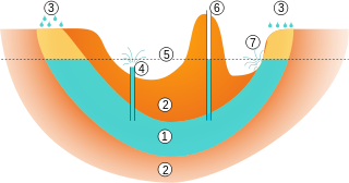
An artesian aquifer is a confined aquifer containing groundwater under positive pressure. An artesian aquifer has trapped water, surrounded by layers of impermeable rock or clay which apply positive pressure to the water contained within the aquifer. If a well were to be sunk into an artesian aquifer, water in the well-pipe would rise to a height corresponding to the point where hydrostatic equilibrium is reached.

The Pannonian Basin, or Carpathian Basin, is a large basin in Central Europe. The geomorphological term Pannonian Plain is more widely used for roughly the same region though with a somewhat different sense, with only the lowlands, the plain that remained when the Pliocene Epoch Pannonian Sea dried out.

The Great Lakes Basin consists of the Great Lakes and the surrounding lands of the states of Illinois, Indiana, Michigan, Minnesota, New York, Ohio, Pennsylvania, and Wisconsin in the United States, and the province of Ontario in Canada, whose direct surface runoff and watersheds form a large drainage basin that feeds into the lakes. It is generally considered to also include a small area around and beyond Wolfe Island, Ontario, at the east end of Lake Ontario, which does not directly drain into the Great Lakes, but into the Saint Lawrence River.

Basin Mountain is the ninth-highest peak of the High Peaks Region in the Adirondack Park in the U.S. State of New York. The peak was named by Verplanck Colvin for several basins formed between knobs on its slopes. It is located in the High Peaks Wilderness Area. A basin is an area of land enclosed by higher land.

Preble's shrew is a small shrew distributed across the Great Basin of the United States and southern British Columbia in Canada. It belongs to the order Eulipotyphla, family Soricidae and genus Sorex.
A continental divide is a drainage divide on a continent such that the drainage basin on one side of the divide feeds into one ocean or sea, and the basin on the other side either feeds into a different ocean or sea, or else is endorheic, not connected to the open sea. Every continent on earth except Antarctica has at least one continental drainage divide; islands, even small ones like Killiniq Island on the Labrador Sea in Canada, may also host part of a continental divide or have their own island-spanning divide.