Delton, Michigan | |
|---|---|
 Delton | |
| Coordinates: 42°29′59″N85°24′29″W / 42.49972°N 85.40806°W | |
| Country | United States |
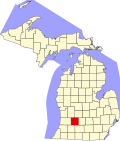
| State | Michigan |
| County | Barry |
| Township | Barry |
| Area | |
• Total | 2.55 sq mi (6.61 km2) |
| • Land | 2.22 sq mi (5.74 km2) |
| • Water | 0.34 sq mi (0.87 km2) |
| Elevation | 947 ft (289 m) |
| Population (2020) | |
• Total | 854 |
| • Density | 385.5/sq mi (148.86/km2) |
| Time zone | UTC-5 (Eastern (EST)) |
| • Summer (DST) | UTC-4 (EDT) |
| ZIP code | 49046 |
| Area code | Area code 269 |
| FIPS code | 26-21560 |
| GNIS feature ID | 0624538 |
Delton is a census-designated place (CDP) in Barry Township in Barry County, Michigan, United States. The population was 854 at the 2020 census. [2]