Delton, Michigan

Last updated

Delton, Michigan
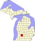
USA Michigan location map.svg
Red pog.svg
Delton
Coordinates: 42°29′59″N85°24′29″W / 42.49972°N 85.40806°W / 42.49972; -85.40806
Country United States
State Michigan
County Barry
Township Barry
Area
[1]
  Total2.55 sq mi (6.61 km2)
  Land2.21 sq mi (5.74 km2)
  Water0.34 sq mi (0.87 km2)
Elevation
947 ft (289 m)
Population
 (2020)
  Total854
  Density385.55/sq mi (148.86/km2)
Time zone UTC-5 (Eastern (EST))
  Summer (DST) UTC-4 (EDT)
ZIP code
49046
Area code Area code 269
FIPS code 26-21560
GNIS feature ID0624538

Delton is a census-designated place (CDP) in Barry Township in Barry County, Michigan, United States. The population was 854 at the 2020 census. [2]

Contents

Geography

Delton is located in southwestern Barry County. It is bordered to the north by Hope Township. To the west the CDP extends slightly into Prairieville Township, Cloverdale and Cedar Creek. State highway M-43 runs through the town center, leading northeast 14 miles (23 km) to Hastings and southwest 19 miles (31 km) to downtown Kalamazoo.

According to the United States Census Bureau, the Delton CDP has a total area of 2.2 square miles (5.8 km2), of which 2.2 square miles (5.6 km2) is land and 0.077 square miles (0.2 km2), or 2.99%, is water. [3] The eastern end of Crooked Lake occupies the western part of the CDP.

Demographics

Historical population
CensusPop.Note
2020 854
U.S. Decennial Census [4]

Related Research Articles

<span class="mw-page-title-main">Barry County, Michigan</span> County in Michigan, United States

Barry County is a county in the U.S. state of Michigan. As of the 2020 United States Census, the population was 62,423. The county seat is Hastings.

<span class="mw-page-title-main">Barry Township, Michigan</span> Township in Michigan, United States

Barry Township is a civil township of Barry County in the U.S. state of Michigan. As of the 2010 census, the township population was 3,378.

<span class="mw-page-title-main">South Gull Lake, Michigan</span> Census-designated place & unincorporated community in Michigan, United States

South Gull Lake is a census-designated place (CDP) in Ross Township, Kalamazoo County, in the U.S. state of Michigan. It includes the unincorporated communities of Yorkville, Gull Lake, and Midland Park and does not have any legal status as an incorporated municipality. The population of the CDP was 1,182 at the 2010 census, down from 1,526 at the 2000 census.

<span class="mw-page-title-main">Michigamme, Michigan</span> Census-designated place & unincorporated community in Michigan, United States

Michigamme is an unincorporated community in Marquette County in the U.S. state of Michigan. It is located within Michigamme Township on the north shores of Lake Michigamme. For statistical purposes, the United States Census Bureau has defined Michigamme as a census-designated place (CDP). The CDP had a population of 255 at the 2020 census.

<span class="mw-page-title-main">Republic, Michigan</span> Census-designated place & unincorporated community in Michigan, United States

Republic is an unincorporated community in Marquette County in the U.S. state of Michigan. It is also a census-designated place (CDP) for statistical purposes and no legal status as an incorporated municipality. The CDP had a population of 470 at the 2020 census, down from 570 in 2010. The community is located mostly within Republic Township with a small portion extending north into Humboldt Township.

<span class="mw-page-title-main">Whitmore Lake, Michigan</span> Census-designated place & unincorporated community in Michigan, United States

Whitmore Lake is a census-designated place (CDP) and unincorporated community in the U.S. state of Michigan. The community spans the boundary between Green Oak Township in Livingston County and Northfield Township in Washtenaw County. The population of the CDP was 7,584 at the 2020 census.

Hickory Corners is a census-designated place (CDP) in Barry Township in Barry County, Michigan, United States. The population was 313 at the 2020 census.

<span class="mw-page-title-main">Dollar Bay, Michigan</span> Census-designated place & unincorporated community in Michigan, United States

Dollar Bay is a census-designated place (CDP) in Houghton County, Michigan, United States. The population was 1,082 at the 2010 census.

<span class="mw-page-title-main">Cross Village, Michigan</span> Census-designated place & unincorporated community in Michigan, United States

Cross Village is an unincorporated community and census-designated place (CDP) in Emmet County in the U.S. state of Michigan. As of the 2010 census, the CDP had a population of 93. It is located within Cross Village Township on the shores of Lake Michigan.

<span class="mw-page-title-main">Carp Lake, Michigan</span> Census-designated place & unincorporated community in Michigan, United States

Carp Lake is an unincorporated community and census-designated place (CDP) in Emmet County in the U.S. state of Michigan. As of the 2010 census, the CDP had a population of 357. It is located within Carp Lake Township.

<span class="mw-page-title-main">Levering, Michigan</span> Census-designated place & unincorporated community in Michigan, United States

Levering is an unincorporated community and census-designated place (CDP) in Emmet County in the U.S. state of Michigan. As of the 2010 census, the CDP had a population of 215.

<span class="mw-page-title-main">Brutus, Michigan</span> Census-designated place & unincorporated community in Michigan, United States

Brutus is an unincorporated community and census-designated place (CDP) in Emmet County in the U.S. state of Michigan. As of the 2010 census, the CDP had a population of 218. Brutus is located within Maple River Township.

<span class="mw-page-title-main">Watersmeet, Michigan</span> Census-designated place & unincorporated community in Michigan, United States

Watersmeet is an unincorporated community and census-designated place (CDP) in Watersmeet Township, Michigan. As of the 2010 census, the CDP had a population of 428, out of a total population in the township of 1,417. The community was platted in 1884, designated as a station of the Milwaukee Lake Shore and Western Railroad.

<span class="mw-page-title-main">Hudson Lake, Indiana</span> Census-designated place in Indiana, United States

Hudson Lake is an unincorporated community and census-designated place (CDP) in Hudson Township, LaPorte County, Indiana, United States. The town sits on the dividing line between Central and Eastern time zones. It is the site of the Hudson Lake station stop of the South Shore Line. As of the 2010 census, the population of the CDP was 1,297.

<span class="mw-page-title-main">Ponshewaing, Michigan</span> Census-designated place & unincorporated community in Michigan, United States

Ponshewaing is an unincorporated community and census-designated place (CDP) in Emmet County in the U.S. state of Michigan. As of the 2010 census, the CDP had a population of 69. It is located within Littlefield Township.

<span class="mw-page-title-main">Oden, Michigan</span> Census-designated place & unincorporated community in Michigan, United States

Oden is an unincorporated community and census-designated place (CDP) in Emmet County in the U.S. state of Michigan. As of the 2010 census, the CDP had a population of 363. It is located within Littlefield Township.

<span class="mw-page-title-main">Conway, Michigan</span> Census-designated place & unincorporated community in Michigan, United States

Conway is an unincorporated community and census-designated place (CDP) in Emmet County in the U.S. state of Michigan. As of the 2010 census, the CDP had a population of 204.

Dowling is a census-designated place (CDP) in Baltimore Township in Barry County, Michigan, United States. The population was 351 at the 2020 census.

<span class="mw-page-title-main">Lake Victoria, Michigan</span> Census-designated place & unincorporated community in Michigan, United States

Lake Victoria is an unincorporated community and census-designated place (CDP) in Clinton County in the U.S. state of Michigan. It is located in Victor Township. As of the 2010 census, it had a population of 930.

<span class="mw-page-title-main">Vineyard Lake, Michigan</span> Census-designated place & unincorporated community in Michigan, United States

Vineyard Lake is an unincorporated community and census-designated place (CDP) in Jackson County in the U.S. state of Michigan. The CDP had a population of 980 at the 2010 census. It is located within Columbia Township to the west and Norvell Township to the east.

References

  1. "2020 U.S. Gazetteer Files". United States Census Bureau. Retrieved May 21, 2022.
  2. "Delton CPD, Michigan - Census Bureau Profile". United States Census Bureau. Retrieved February 26, 2024.
  3. "Geographic Identifiers: 2010 Demographic Profile Data (G001): Delton CDP, Michigan". U.S. Census Bureau, American Factfinder. Archived from the original on February 12, 2020. Retrieved December 23, 2013.
  4. "Census of Population and Housing". Census.gov. Retrieved June 4, 2016.