
Charlotte is the most populous city in the U.S. state of North Carolina and the county seat of Mecklenburg County. The population was 874,579 at the 2020 census, making Charlotte the 15th-most populous city in the United States, the seventh-most populous city in the South, and the second-most populous city in the Southeast behind Jacksonville, Florida. Charlotte is the cultural, economic, and transportation center of the Charlotte metropolitan area, whose estimated 2023 population of 2,805,115 ranked 22nd in the United States. The Charlotte metropolitan area is part of an 18-county market region and combined statistical area with an estimated population of 3,387,115 as of 2023.

Iredell County is a county located in the U.S. state of North Carolina. As of the 2020 census, the population was 186,693. Its county seat is Statesville, and its largest community is Mooresville. The county was formed in 1788, subtracted from Rowan County. It is named for James Iredell, one of the first justices of the Supreme Court. Iredell County is included in the Charlotte-Concord-Gastonia, NC-SC Metropolitan Statistical Area, as defined by the Office of Management and Budget, with data from the U.S. Census Bureau.

Scouting in North Carolina has a long history, from the 1910s to the present day, serving thousands of youth in programs that suit the environment in which they live.

Concord is the county seat of and most populous city in Cabarrus County, North Carolina, United States. The city had a population of 105,240 at the 2020 census. Concord is the second-most populous city in the Charlotte metropolitan area, tenth-most populous city in North Carolina and 287th-most populous city in the U.S.

Belmont is a small suburban city in Gaston County, North Carolina, United States, located about 9 miles (14 km) east of Gastonia. The population was 10,076 at the 2010 census. Once known as Garibaldi Station, it was named for the New York banker August Belmont. Belmont is home to Belmont Abbey College.

Mooresville is a town located in the southwestern section of Iredell County, North Carolina, United States, and is a part of the fast-growing Charlotte metropolitan area. The population was 50,193 at the 2020 census, making it the most populous municipality in Iredell County. It is located approximately 25 miles (40 km) north of Charlotte.
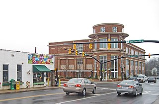
Huntersville is a large suburban town in northern Mecklenburg County, North Carolina, United States. At the 2020 census, its population was 61,376, making Huntersville the 15th-most populous municipality in North Carolina. It is located in the Charlotte metropolitan area and 14 mi (23 km) north of Charlotte.

Matthews is a town in southeastern Mecklenburg County, North Carolina, United States. It is a suburb of Charlotte. The population was 27,198 according to the 2010 census.

Davidson is a suburban town located in Iredell and Mecklenburg counties, North Carolina, United States, on the banks of Lake Norman. It is a suburb in the Charlotte metropolitan area. The population was 10,944 at the 2010 census, and in 2019 the estimated population was 13,054. The town was founded in 1837 with the establishment of the Presbyterian Davidson College, named for Brigadier General William Lee Davidson, a local Revolutionary War hero. The land for Davidson College came from Davidson's estate, a large portion of which was donated by his son.

Myers Park is a neighborhood and historic district in Charlotte, North Carolina, United States.
Uptown Charlotte, also called Center City, is the central business district of Charlotte, North Carolina, United States. The area is split into four wards by the intersection of Trade and Tryon Streets, and bordered by Interstate 277 and Interstate 77. The area is managed and overseen by the Charlotte Central City Partners, which is one of the three Municipal Service Districts in Charlotte. Uptown Charlotte is the largest business district in Charlotte and the Carolinas.
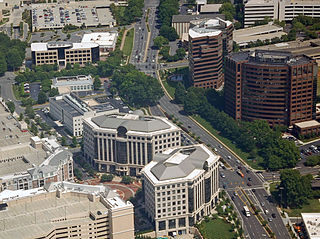
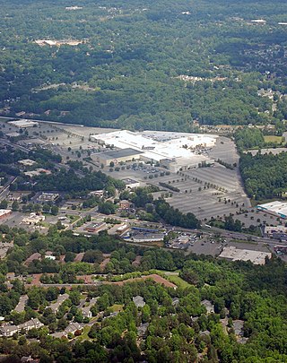
SouthPark is an area edge city in Charlotte, North Carolina, United States. Its name is derived from the upscale SouthPark Mall, which opened on February 12, 1970. At nearly 1.8 million square feet, SouthPark Mall is the largest shopping mall in Charlotte and all of the Carolinas. The area is geographically centered at the intersection of Fairview Road and Sharon Road in the south central sector of the city, about six miles south of Uptown Charlotte. In addition to being home to the mall, SouthPark is also a residential area and one of the larger business districts in Charlotte.
Plaza-Midwood is a neighborhood located approximately one mile to the northeast of Uptown in Charlotte, North Carolina. The neighborhood is roughly bound by Hawthorne Lane to the west, The Plaza to the north, Briar Creek Road and the Charlotte Country Club to the east and Central Avenue to the south.
Eastland is a neighborhood in Charlotte, North Carolina, USA. The area is named after the former eponymous mall, that was demolished in 2014. Eastland is almost seven and a half miles from Uptown, Charlotte.

Dilworth is a neighborhood of Charlotte, Mecklenburg County, North Carolina, United States. The neighborhood was Charlotte's first streetcar suburb and was established by Edward Dilworth Latta in the 1890s on 250 acres (1 km²) southwest of the original city limits. It included the Joseph Forsyth Johnson designed Latta Park. Planned largely with a grid pattern similar to the city's original four wards, Dilworth was initially designated the Eighth Ward.
Sedgefield is a neighborhood of Charlotte, North Carolina, United States. It is situated between Park Rd. and South Blvd and belongs to popular South End.

The Cotswold neighborhood of Charlotte, North Carolina, United States, was named after the region of the same name in England. It is well-known for a large shopping center, Cotswold Village Shops, located at the intersection of Randolph and Sharon Amity Roads. Originally known as Cotswold Mall, it was one of Charlotte's first suburban malls. Cotswold is emerging as one of the more desirable areas for living and shopping with close proximity to Uptown. Many 1950s and 1960s homes are being remodeled and sold.
The Charlotte metropolitan area, sometimes referred to as Metrolina, is a metropolitan area of the U.S. states of North and South Carolina, containing the city of Charlotte, North Carolina. The metropolitan area also includes the cities of Gastonia, Concord, Huntersville, and Rock Hill as well as the large suburban area in the counties surrounding Mecklenburg County, which is at the center of the metro area. Located in the Piedmont, it is the largest metropolitan area in the Carolinas, and the fourth largest in the Southeastern United States. The Charlotte metropolitan area is one of the fastest growing metropolitan areas in the United States.
The Stonehaven neighborhood of Charlotte, North Carolina was established in the 1950s. In addition to the Stonehaven subdivision, the area also includes the Olde Stonehaven, Queens Grant, Rama Woods, Waverly Hall and Medearis subdivisions. The neighborhood is bounded by Rama Road to the northwest, Sardis Road to the southwest, McAlpine Creek to the southeast and a railroad track and Monroe Road to the northeast. The area is neighbored by the areas known as Sherwood Forest, Landsdowne, McClintock Woods, and Sardis Woods. The area's dominant architectural style is the ranch-style house with brick or wood exterior.


